Memorandum
Date January 17, 2012
TO Boston Region Metropolitan Planning Organization
FROM Karl H. Quackenbush
CTPS Executive Director
RE Work Program for: Modeling Support for MassDOT EIS for the I-93/I-95 Interchange Improvements Project North of Boston
Review and approval
That the Boston Region Metropolitan Planning Organization, upon the recommendation of the Massachusetts Department of Transportation, vote to approve the work program for Modeling Support for MassDOT EIS for the I-93/I-95 Interchange Improvements Project North of Boston in the form of the draft dated January 17, 2012.
Planning Studies
73216
Massachusetts Department of Transportation, Highway Division
Project Supervisor: Diane Madden
Principal: Scott Peterson
Manager: Ying Bao
MassDOT Contract #TBD – Funding Source: State Capital Funds
The MPO staff has sufficient resources to complete this work in a capable and timely manner. By undertaking this work, the MPO staff will neither delay the completion nor reduce the quality of other work in the UPWP.
The Massachusetts Department of Transportation (MassDOT) intends to redesign and reconstruct the I-93/I-95 interchange to improve traffic flow and safety. The I‑93/I-95 interchange lies at the center of a regional highway network serving Massachusetts and the rest of New England. It is also an important facility for the local communities of Woburn, Reading, Stoneham, Wakefield, and neighboring towns. This interchange experiences heavy traffic volumes during peak hours. Delays are common during peak commuting times, with traffic often backed up dangerously from the ramps onto the mainline highways.
The I-93/I-95 interchange ranked among the top five worst crash sites in Massachusetts in terms of safety between 2006 and 2010. This interchange also has had the highest or nearly highest annual crash rates prior to 2006 when compared to other cloverleaf interchanges and all interchanges in Massachusetts. The cloverleaf design creates four weaves that are significantly shorter than weaving distance standards, creating many conflicts between vehicles leaving one loop ramp and those entering the adjacent loop whose paths must cross.
In 2001, the Central Transportation Planning Staff (CTPS) assisted MassDOT and its consulting team in performing a conceptual design and feasibility study for operational improvements to the I-93/I-95 interchange. That study was suspended by MassDOT and replaced by an in-depth planning study, completed in 2007, that analyzed and recommended several short-term and long-term improvement alternatives, for which CTPS provided travel demand modeling support. As a part of the required National Environmental Policy Act (NEPA) and Massachusetts Environmental Policy Act (MEPA) processes, and to complete an Environmental Impact Statement (EIS) and Environmental Impact Report ( EIR), MassDOT now desires to refine and develop variations of the alternative interchange configurations as well as evaluate the potential for improvements that would enhance mobility and safety for users. A set of alternatives, including interchange improvements, transit service improvements, and other types of improvements, will be modeled and analyzed using the Boston Region MPO’s regional travel demand model set.
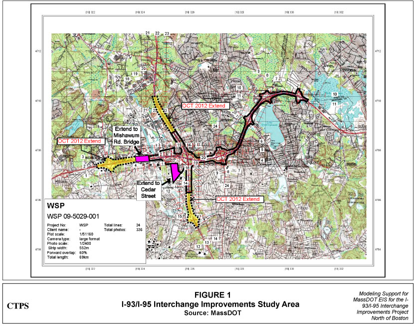
The study area is I-95/Route 128 between Exit 35 and Exit 41, I-93 between I-93 between Exit 37C and Exit 36/Montvale Avenue, and the nearby arterials and local roads. Figure 1 (at the end of this work program) shows the study area.
Using the Boston Region MPO regional travel demand model set, CTPS will support MassDOT and the study team by assessing the existing traffic conditions and travel patterns, and providing modeling results and analyses for use in the evaluation of various proposed construction plans for the I-93/I-95 interchange in the horizon years of 2020 and 2035. CTPS will also provide highway and transit volume forecasts, air quality analyses, and environmental-justice analyses. The results will be summarized in sufficient detail to allow the study team to realistically compare alternatives.
The work required to accomplish the study objectives will be carried out in nine tasks, as described below:
CTPS will compile all available counts relevant to this study, including MassDOT historical traffic volumes, automatic-traffic-recorder (ATR) counts, and turning movement counts already collected by the study team for this study and data from other studies. These counts will be utilized for base-year model calibration to the greatest extent possible.
As part of this task, CTPS will collect auto occupancy counts and vehicle classification counts on I-93 south of this interchange in the AM peak period and will process them for the use of base-year model calibration. CTPS will also coordinate with the study team to investigate the crash data associated with the study area in a recent five-year period.
CTPS will conduct a license plate survey on eight ramps of the I-93/I-95 interchange in the AM peak period. The origin towns and transportation analysis zones (TAZs) of the vehicles using these ramps will be mapped by matching each vehicle license plate to the town where the vehicle is garaged, according to Registry of Motor Vehicles records. The results from this survey will be utilized to analyze the travel patterns estimated by the base-year model.
At the above locations, CTPS staff will station visual equipment for the recording of license plates as vehicles pass these stations.
Tabular summaries of trip origins from license plate survey
This task consists of refining the roadway network of the Boston Region MPO regional travel demand model set in the vicinity of the I-93/I-95 interchange study area and along the I-95 and I-93 corridors. CTPS will develop a method to convert the model’s peak-period volumes to peak-hour volumes using the most recent count data. The calibration efforts will focus on comparing peak-hour (AM and PM) and daily volumes to empirical counts for interchanges, connecting links, and up to 20 nearby intersections in the study area.
The peak-period trip flows on the key ramps of the I-93/I-95 interchange will be carefully examined by conducting select link analyses to ensure that trips are coming from the correct TAZs.
Daily ridership on selected transit services in the corridor, including commuter rail and buses, and boardings at selected stations near the study area will be compared to recent counts.
A calibrated multimodal travel demand model set for the study area
CTPS will reach out to the communities of Woburn, Reading, Stoneham, and Wakefield to identify proposed developments in the vicinity of the study area. In this task, the proposed developments will be integrated with the Boston Region MPO’s Long-Range Transportation Plan (LRTP) to create the demographic and land use profiles for the 2020 and 2035 no-build scenarios. The reason for choosing year 2020 as an interim year is because it is expected that the construction of this project will start in 2020. CTPS will prepare data for the regional travel demand model set based on the proposed developments and other land use assumptions. The number of jobs and number of residential units generated by the proposed future uses and gross estimates of square footage will be converted into the data format required by the regional model set. CTPS will also consult with the study team and the Metropolitan Area Planning Council (MAPC) about adjusting the socioeconomic data for the study area. This adjustment will be based on municipal control totals for households, population, and employment from the LRTP. If the data cannot be provided by the towns and city, CTPS staff will produce data using their professional judgment. The resultant land use data will be used as inputs to the Boston Region MPO regional travel demand model set for the horizon years 2020 and 2035.
Refined land use plan at the TAZ level in tabular form for the 2020 and 2035 scenarios in the requested format
CTPS will develop the 2020 and 2035 no-build scenarios for this study. The no-build scenarios will incorporate the land use assumptions developed in the previous task. CTPS will also update the current LRTP no-build multimodal transportation systems for 2020 and 2035, allowing for limited changes to provide accessibility to the proposed developments. The outputs of the no-build model runs will be used as the basis for analyzing the impacts of the build scenarios described in the next task.
CTPS will model up to a maximum of six build scenarios for 2020 and for 2035, including a high-occupancy-vehicle (HOV) lane scenario and a transit scenario. The build scenarios will utilize the same land use and demographic assumptions as the no-build scenarios developed in the previous task. The regional model set will be run to produce peak-hour and daily travel forecasts for these alternatives.
The results will be analyzed, comparing traffic conditions under the no-build scenario to conditions with various interchange reconfigurations. The comparisons will be made for peak-hour and daily volumes, daily vehicle-miles traveled (VMT), daily vehicle-hours traveled (VHT), and mode shifts in the study area. CTPS will conduct select link analyses on the I-93 and I-95 mainlines and on the key ramps of the interchange to examine the change of traffic flows and regional travel patterns due to these interchange improvements.
The daily passenger ridership and boardings on the selected transit lines and stations in the study area will be summarized to evaluate the impacts of the interchange improvements and transit service improvements on the transit riders.
Tabular and graphic summaries comparing each build scenario with the corresponding no-build scenario in terms of traffic volumes, turning movements, VMT, VHT, and transit ridership
CTPS will work in coordination with the study team on air quality analyses based on the model results. The air quality analysis estimates emissions from cars and trucks of carbon monoxide (CO), carbon dioxide (CO2), nitrogen oxides (NOx), volatile organic compounds (VOCs), and particulate matter (PM2.5 and PM10). Emissions from commuter rail diesel locomotives, transit service boats, and MBTA buses and some automobile emissions associated with park-and-ride lots will be estimated off-model.
CTPS will conduct environmental-justice analyses for the proposed interchange improvements. After identifying communities of concern, performance measures—accessibility to health care, higher education, and jobs; mobility and congestion; and environmental impacts—will be used as indicators of benefits and burdens for environmental-justice and non-environmental-justice communities.
CTPS will also conduct health impact analyses and provide data as needed. The health impact analyses will use GIS tools to examine the impacts of the traffic-related exposures of the populations living and/or working in the project study area.
CTPS will work with the project team throughout the study, with an anticipated time frame for modeling involvement of approximately one year. In the event of project delays beyond the control of CTPS, the timing of project deliverables will be consistent with revised schedules set by the MassDOT project team. CTPS staff time and budget estimates reflect attendance at a maximum of seven internal meetings and five project stakeholder meetings. (If necessary, and upon mutual agreement between CTPS and the MassDOT project team, the number of meetings may be revised and/or restructured to be responsive to any changes in the project schedule.) CTPS will fulfill any data requests from the project team when the data are readily available, and will educate the stakeholders about the work included in this scope.
Coordination with the study team, attendance at meetings, and other assistance as needed
A technical memorandum documenting all of the model methodology, assumptions, and results and the analysis findings will be provided to MassDOT and the study team. The technical memorandum will be suitable for general audiences, as appropriate for EIS and EIR documentation.
A technical memorandum documenting the project
It is estimated that this project will be completed approximately 12 months after work commences. The proposed schedule, by task, is shown in Exhibit 1.
The total cost of this project is estimated to be $157,000. This includes the cost of 58.6 person-weeks of staff time and overhead at the rate of 96.58 percent. A detailed breakdown of estimated costs is presented in Exhibit 2.
KQ/YB/yb
Task |
Month | |||||||||||
|---|---|---|---|---|---|---|---|---|---|---|---|---|
| 1 | 2 | 3 | 4 | 5 | 6 | 7 | 8 | 9 | 10 | 11 | 12 | |
|
1.
Collect Traffic Data |
From month 1 to 2.5.
| |||||||||||
|
2.
Conduct License Plate Survey |
From month 1 to 3.
| |||||||||||
|
3.
Perform Base-Year Model Calibration |
From month 1 to 3.5.
| |||||||||||
|
4.
Develop Land Use Inputs for 2020 and 2035 Scenarios |
From month 2.5 to 5.
| |||||||||||
|
5.
Model Future-Year No-Build Scenarios for 2020 and 2035 |
From month 3.5 to 6.5.
| |||||||||||
|
6.
Develop and Model Multiple Build Scenarios and Analyze Results |
From month 5.5 to 10.5.
| |||||||||||
|
7.
Perform Air Quality Analyses, Environmental-Justice Analyses, and Health Impact Analyses |
From month 6.5 to 11.5.
| |||||||||||
|
8.
Coordinate with Project Team and Provide Ongoing Technical Assistance |
From month 1 to 13.
| |||||||||||
|
9.
Produce a Technical Memorandum |
From month 9 to 13.
Month 13, deliverable A, A technical memorandum documenting the project.
| |||||||||||
Task |
Person-Weeks | Direct Salary |
Overhead (96.58%) |
Total Cost |
|||||
|---|---|---|---|---|---|---|---|---|---|
| M-1 | P-5 | P-4 | P-2 | Temp | Total | ||||
|
1.
Collect Traffic Data |
0.1 | 2.0 | 0.4 | 0.5 | 1.0 | 4.0 | $4,951 | $4,781 | $9,732 |
|
2.
Conduct License Plate Survey |
0.0 | 1.0 | 0.0 | 2.5 | 6.5 | 10.0 | $7,008 | $6,768 | $13,776 |
|
3.
Perform Base-Year Model Calibration |
0.5 | 1.5 | 2.0 | 0.0 | 0.0 | 4.0 | $5,931 | $5,728 | $11,659 |
|
4.
Develop Land Use Inputs for 2020 and 2035 Scenarios |
0.5 | 1.5 | 0.0 | 0.0 | 0.0 | 2.0 | $3,364 | $3,249 | $6,612 |
|
5.
Model Future-Year No-Build Scenarios for 2020 and 2035 |
0.5 | 3.0 | 2.0 | 0.0 | 0.0 | 5.5 | $8,404 | $8,117 | $16,521 |
|
6.
Develop and Model Multiple Build Scenarios and Analyze Results |
1.5 | 3.5 | 9.5 | 0.0 | 0.0 | 14.5 | $20,381 | $19,684 | $40,065 |
|
7.
Perform Air Quality Analyses, Environmental-Justice Analyses, and Health Impact Analyses |
0.5 | 4.0 | 3.5 | 0.0 | 0.0 | 8.0 | $11,975 | $11,565 | $23,540 |
|
8.
Coordinate with Project Team and Provide Ongoing Technical Assistance |
1.5 | 2.0 | 0.0 | 0.0 | 0.0 | 3.5 | $5,897 | $5,695 | $11,592 |
|
9.
Produce a Technical Memorandum |
3.0 | 2.0 | 2.0 | 0.0 | 0.0 | 7.0 | $11,041 | $10,663 | $21,704 |
|
Total |
8.1 | 20.6 | 19.4 | 3.0 | 7.5 | 58.6 | $78,950 | $76,250 | $155,200 |