
Transportation Improvement Program
Federal Fiscal Year 2025-29
APPENDICES
DRAFT FOR THE MPO, June 6, 2024
DRAFT FOR THE MPO, June 6, 2024
Appendix A: Project Prioritization and Scoring
Appendix B: Greenhouse Gas Monitoring and Evaluation
Appendix C: Public Engagement and Public Comments
Appendix D: Geographic Distribution of TIP Funding
Appendix E: Regulatory and Policy Framework
Appendix F: Boston Region Metropolitan Planning Organization Membership
Appendix G: Operations and Maintenance Summary
As described in Chapter 2, the Transportation Improvement Program (TIP) development and project prioritization and funding process consists of numerous phases and is supported by several different funding sources. This appendix includes information about transportation projects that the Boston Region Metropolitan Planning Organization (MPO) considered for funding through the Highway Discretionary (Regional Target) Program in the federal fiscal years (FFYs) 2025–29 TIP.
To be considered for funding by the MPO, a project must fulfill certain basic criteria. Projects evaluated through the MPO’s Bicycle Network and Pedestrian Connections, Complete Streets, and Intersection Improvements investment programs must meet these criteria:
For projects evaluated through the MPO’s Transit Transformation Program, the following criteria apply:
For projects evaluated through the MPO’s Community Connections Program, the following criteria apply:
If a project meets the above criteria, it is presented to the MPO board in the Universe of Projects (Table A-1) to be considered for funding. This project list is presented to the MPO board in November and provides a snapshot of information available on projects at that stage in the TIP development. Some projects that get evaluated for funding may not appear in the Universe, as more project information may become available following the compilation of the Universe. In addition, some projects that appear on the Universe list may not be evaluated each year if these projects are not actively being advanced by municipal or state planners or if they are not at the minimum required level of design for evaluation. Community Connections projects are not typically included in the Universe because proponents of those projects apply for funding through a discrete application process, the submission deadline for which is after the presentation of the Universe to the MPO board.
Once a proponent provides sufficient design documentation for a project in the Universe and the municipality or state is actively prioritizing the project for funding, the project can be evaluated by MPO staff. The evaluation criteria used to score projects are based on the MPO’s goals and objectives. After the projects are evaluated, the scores are shared with project proponents, posted on the MPO’s website, and presented to the MPO board for review and discussion. The scores for projects evaluated during development of the FFYs 2025–29 TIP for programming in the MPO’s Bicycle Network and Pedestrian Connections, Complete Streets, and Intersection Improvements programs are summarized in Table A-3. No projects were evaluated for inclusion in the Major Infrastructure investment program during the development of the FFY 2025-29 TIP. Scores for projects that applied for funding through the MPO’s Community Connections Program during the FFYs 2025–29 TIP cycle are summarized in Table A-4.
Following the adoption of Destination 2050 in July 2023, the MPO revised the TIP evaluation criteria to better align with the MPO’s updated goals, objectives, and investment programs, including a new resilience goal area. These new criteria were employed during the project selection process for the FFYs 2025-29 TIP. The final criteria were informed by robust public engagement conducted during the development of Destination 2050 and developed through an update process that engaged MPO members, staff, and external stakeholders. The most significant update to the criteria for the FFYs 2025-29 TIP was the development of new and broader resilience evaluation metrics to align with the resilience goal area in Destination 2050 and elevate resilience to equal consideration in project prioritization alongside other goal-focused TIP criteria. This update created separate criteria for different project types within the Community Connections program given the diverse array of first-and-last mile projects that can be funded through the program.
The project selection criteria for each investment program are shown in separate tables in this appendix as follows: Bicycle Network and Pedestrian Connections (Table A-5); Complete Streets (Table A-6); Intersection Improvements (Table A-7); and Transit Transformation (Table A-8).
Community Connections project selection criteria are shown in separate tables in this appendix as follows: Bicycle Lanes (A-9); Bicycle Racks (A-10); Bikeshare Support (A-11); Microtransit Pilots (A-12); and Wayfinding Signage (A-13).
Archived project evaluation criteria for all investment programs, which were discontinued in October 2023 after the FFYs 2024–28 TIP cycle, are shown in Tables A-14 and A-15.
In addition to project scores, several other factors are taken into consideration by the MPO when selecting projects for funding. Table A-2 describes many of these elements, including the relationships between the MPO’s FFYs 2025–29 Regional Target projects and the MPO’s Long-Range Transportation Plan (LRTP), studies and technical assistance conducted by MPO staff through the Unified Planning Work Program (UPWP), the federally required performance measures discussed in Chapter 4, and Massachusetts’ modal plans. These projects are listed by MPO investment program. More details about each of these projects are available in the funding tables and project descriptions included in Chapter 3. Performance-related information for the FFYs 2025–29 Regional Target projects is included in Chapter 4, and information about greenhouse gas (GHG) emissions for these projects is available in Appendix B.
Table A-1
FFYS 2025–29 TIP Universe of Projects
| This table contains unprogrammed projects in the Boston region that may be considered for evaluation in the FFYs 2025-29 TIP cycle. Not all projects listed in this table will be evaluated for funding in the FFYs 2024-28 TIP, as projects must be approved by the Project Review Committee and proponents must submit sufficient project documentation prior to scoring. The MPO has also established a policy to prioritize projects that have reached the 25% design submission stage for funding. This list is subject to change as more project information is received. | |||||||||||||
| Key | |||||||||||||
| Evaluated for FFYs 2024-28 TIP | |||||||||||||
| New project in TIP universe for FFYs 2025-29 TIP | |||||||||||||
| In 2024-28 universe, not evaluated | |||||||||||||
| Municipality | Project Proponent | Project Name | PROJIS | Design Status (as of 10/6/21) | Year Added to Universe | Cost Estimate | MAPC Subregion | Highway District | MPO Investment Program | Notes | Limits | MAPIT? | Previous Evaluation Score |
| Inner Core | |||||||||||||
| Complete Streets | |||||||||||||
| Boston | Boston | Reconstruction of Albany Street | N/A | Pre-PRC | 2021 | N/A | 6 | Pursuing 2022 PRC approval. | N/A | ||||
| Boston | MassDOT | Reconstruction on Gallivan Boulevard (Route 203), from Neponset Circle to East of Morton Street Intersection | 606896 | PRC approved (2012) | 2018 | $11,500,000 | ICC | 6 | Complete Streets | Resulted from FFY 2012 Addressing Priority Corridors MPO Study | N/A | ||
| Boston | MassDOT | Improvements on Morton Street (Route 203), from West of Gallivan Boulevard to Shea Circle | 606897 | PRC approved (2012) | 2018 | $11,500,000 | ICC | 6 | Complete Streets | Resulted from FFY 2012 Addressing Priority Corridors MPO Study | N/A | ||
| Boston | Boston | Roadway Improvements along Commonwealth Avenue (Route 30), from Alcorn Street to Warren/Kelton Streets (Phase 3 & Phase 4) | 608449 | 25% submitted (9/28/2017) | 2017 or earlier | $31,036,006 | ICC | 6 | Major Infrastructure | Last scored for FFYs 2020-24 TIP. | 56 | ||
| Boston | MassDOT | Intersection & Signal Improvements at VFW Parkway and Spring Street | 607759 | 25% Package Received - R1 (3/09/2022) | 2022 | $4,526,907 | 6 | N/A | |||||
| Boston | MassDOT | Boston - Gallivan Boulevard (Route 203) Safety Improvements, From Washing | 610650 | PRC approved (2019) | 2019 | $5,750,000 | ICC | 6 | Complete Streets | Priority for District 6. Road safety audit being initiated. | N/A | ||
| Brookline | Brookline | Boylston Street (High Street to Brington Road) Complete Streets Improvements | N/A | Pre-PRC | 2022 | $3,500,000 | 6 | Ped crossings, bike lanes, street trees. Design through Toole with some facilitation from MassDOT. Three options were pushed through and endorsed by the Select Board. Town met with District 6 to run through this. Should be in PRC soon. | N/A | ||||
| Brookline | Brookline | Davis Street Path Restoration and Reconstruction of the Davis Street Path Bridge over MBTA | N/A | Pre-PRC | 2022 | $12,000,000 | 6 | Conceptual stage. Brookline is investigating avenues to use federal discretionary grant funding to advance this project. Potential for bundling with Boylston Street work above. | N/A | ||||
| Chelsea | Chelsea | Reconstruction of Spruce Street, from Everett Avenue to Williams Street | 610675 | PRC approved (2019) | 2019 | $5,408,475 | ICC | 6 | Complete Streets | N/A | |||
| Chelsea | Chelsea | Reconstruction of Everett Avenue and 3rd Street, from Broadway to Ash Street | N/A | Pre-PRC | 2020 | N/A | 6 | N/A | |||||
| Chelsea | Chelsea | Reconstruction of Marginal Street | N/A | Pre-PRC | 2019 | N/A | ICC | 6 | Complete Streets | N/A | |||
| Lynn, Salem | MassDOT | Reconstruction of Route 107 | 608927 | PRC approved (2017) | 2020 | $38,155,000 | 4 | N/A | |||||
| Malden | Malden | Broadway Corridor Reconstruction | N/A | Pre-PRC | 2022 | N/A | 4 | Malden is currently holding community meetings to discuss this project, with the most recent one being held 10.25.2022. | N/A | ||||
| Melrose | Melrose | Reconstruction of Lebanon Street, from Lynde Street to Malden City Line | 612534 | PRC approved (2/10/2022) | 2020 | $3,742,432 | 4 | N/A | |||||
| Newton | Newton | Reconstruction of Washington Street, from Church Street to Chestnut Street | N/A | Pre-PRC | 2020 | N/A | 6 | N/A | |||||
| Revere | Revere | Reconstruction of Ocean Ave, Revere Street, and Revere Beach Boulevard | N/A | Pre-PRC | 2020 | N/A | 4 | Project at conceptual stage with schematics, needs full design - investigating roundabout. Key East/West connection. | N/A | ||||
| Winthrop | Winthrop | Reconstruction & Improvements on Route 145 | N/A | PRC approved (2019) | 2019 | $7,565,512 | ICC | 6 | Complete Streets | N/A | |||
| Intersection Improvements | |||||||||||||
| Boston, Brookline | Boston, Brookline | Mountfort St. & Commonwealth Ave. Connection | 608956 | PRC approved (2017) | 2018 | $916,883 | ICC | 6 | Intersection Improvements | Preliminary design. | N/A | ||
| Lynn | Lynn | Intersection Safety Improvements at Boston Street at Hesper & Hamilton Streets | N/A | Pre-PRC | 2023 | $3,000,000 | 4 | Based on 3/3/2023 meeting with Lynn. | |||||
| Medford | Medford | Intersection Improvements at Main Street and South Street | 611974 | PRC approved (2021) | 2019 | $8,498,000 | ICC | 4 | Intersection Improvements | Project location studied by CTPS. Priority for municipality. Design is in progress, and eventually the City will work with MassDOT to fund construction. | N/A | ||
| Newton | MassDOT | Route 16 at Quinobequin Road | 612613 | PRC approved (2/10/2022) | 2022 | $4,350,000 | 6 | Reconfiguration of the interchange may result in consideration of this project for the LRTP. | |||||
| Quincy | MassDOT | Intersection Improvements at Route 3A (Southern Artery) and Broad Street | 608569 | PRC approved (2016) | 2020 | $2,900,000 | 6 | Priority for District 6. | N/A | ||||
| Quincy | Quincy | Intersection Improvements at Willard Street and Ricciuti Drive | 610823 | 25% Package Received - R1 (1/27/2023) | 2020 | $1,145,580 | 6 | 25% design complete. PM is Kathy Dougherty. | N/A | ||||
| Quincy | Quincy | Merrymount Parkway Phase II | N/A | Pre-PRC | 2022 | N/A | 6 | December PRC. Intersection improvement at Merrymount Parkway and Furnace Brook Parkway. Parks Department is leading the work - David Murphy (617-376-1251). Will include bridge replacement. | N/A | ||||
| Bicycle and Pedestrian | |||||||||||||
| Belmont | Belmont | Belmont Community Path Phase 2 | N/A | Pre-PRC | 2023 | TBD | 4 | akoumoutsos@tooledesign.com reached out 3/16/2023 to discuss initiation and funding through MassDOT | |||||
| Boston | Boston | Fenway Multi-Use Path Phase III | N/A | Pre-PRC | 2021 | N/A | 6 | Project at conceptual stage. | N/A | ||||
| Brookline | Brookline | Beacon Street Bridle Pathway | N/A | Pre-PRC | 2022 | N/A | 6 | Project in conceptual design through Toole, receipt of a MassTrails grant in 2020 for feasibility study. Limits would be Audubon Circle to Cleveland Circle. | N/A | ||||
| Everett, Somerville | DCR | Mystic River Bicycle and Pedestrian Crossing | 612004 | PRC approved (2021) | 2021 | $38,218,334 | 4 | N/A | |||||
| Malden | Malden | Spot Pond Brook Greenway | 613088 | Pre-PRC - 25% design | 2022 | $3,250,000 | 4 | Application obtained for 2024-2028. | |||||
| Medford | Medford | Wellington Phase 4 Shared Use Path | 613082 | Pre-PRC | 2022 | $1,195,000 | 4 | ID # is not yet in PINFO. Initiated on 11/3/2022. Includes an earmark and Gaming Commission money. | N/A | ||||
| Medford | Medford | MacDonald Park Pedestrian Bridge | N/A | Pre-PRC | 2022 | $800,000 | 4 | In DCR park, City is requesting expansion of bridge to 10-12feet in width to coordinate with shared use pathway. | N/A | ||||
| Major Infrastructure | |||||||||||||
| Boston, Chelsea | Boston | Bridge Rehabilitation and Fender Pier Replacement, Meridian Street Over Chelsea Creek (Andrew P. McArdle Bridge) | 600637 | PRC Approved (2/10/2022) | 2021 | $97,538,787 | 6 | N/A | |||||
| Cambridge | DCR | Intersection Improvements at Fresh Pond Parkway/Gerry's Landing Road, from Brattle Street to Memorial Drive | 609290 | PRC approved (2018) | 2019 | $7,000,000 | ICC | 6 | Intersection Improvements | Short-term improvements being initiated. | N/A | ||
| Revere, Malden | MassDOT | Improvements on Route 1 (NB) Add-A-Lane | 610543 | PRC approved (2019) | 2019 | $7,210,000 | ICC | 4 | Major Infrastructure | Project is not programmed in Destination 2040. It is located on a regionally significant roadway. If this work includes capacity-adding elements, and it is programmed in the TIP, it will need to be included in Destination 2050. | N/A | ||
| Newton | MassDOT | Traffic Signal and Safety Improvements at Interchange 127 (Newton Corner) | 609288 | PRC approved (2018) | 2019 | $14,000,000 | ICC | 6 | Intersection Improvements | N/A | |||
| Medford | Medford | Roosevelt Circle Interchange Reconfiguration | N/A | Pre-PRC | 2022 | TBD | 4 | As discussed on 11.4.2022 with the City of Medford, the City is looking to reconfigure the ramps and adjacent local roadways to improve traffic safety following the results of a RSA along this corridor. Includes improvements for bicycle, pedestrian, and transit access. Given the state of repair on the bridges, this may be coordinated with bridge rehabilitation work for these structures over I-93. | N/A | ||||
| Boston | Boston | Cambridge Street Bridge Replacement - Charlestown | 612989 | PRC approved (12/21/2022) | 2022 | $15,400,000 | 6 | City wants this programmed to advertise this before Rutherford Avenue enters construction. This is a difficult bridge under I-93 and next to Sullivan Square. | N/A | ||||
| Revere | Revere | Route 1A Improvement and Reconfiguration | N/A | Pre-PRC | 2022 | $9-12,000,000 | 4 | Project is in conceptual design stage. The priority is to reconfigure the loop ramps at the General Edwards Bridge to facilitate redevelopment of the area, for which there are already parcel developments planned. The reconfiguration will entail construction of a new roundabout and improved pedestrian crossings to improve access to the riverfront and Point of Pines area along Revere. Per the City, this reconfiguration is intended to work with the Lynnway Multimodal Corridor improvements, but will also not impact construction for the General Edwards Bridge replacement. | N/A | ||||
| Revere, Saugus | Revere, Saugus | Roadway Widening on Route 1 North (Phase 2) | 611999 | PRC approved (2021) | 2021 | $2,397,600 | 4 | Project is not programmed in Destination 2040. It Is on a regionally-significant roadway and would add roadway capacity. If programmed in the TIP, this project will also need to be included in Destination 2050. Robins Road to Route 99 interchange are the limits. | N/A | ||||
| Community Connections | |||||||||||||
| Belmont | Belmont | Belmont BlueBikes Expansion | N/A | N/A | 2022 | $250,000 | 4 | Belmont is currently evaluating potential revenue streams to cover operational costs and match prior to submitting an application for this project. | N/A | ||||
| Lynn | Lynn | Transit Signal Priority - Bus Upgrades for Lynn Route 107 | N/A | N/A | 2022 | TBD | 4 | Indicated in November 8th email to Ethan from Aaron Clausen | N/A | ||||
| Waltham | Waltham | Waltham BlueBikes/Bikeshare Expansion | N/A | N/A | 2022 | TBD | 4 | Indicated in November 8th email to Ethan from Catherine Cagle. | N/A | ||||
| Minuteman Advisory Group on Interlocal Coordination | |||||||||||||
| Complete Streets | |||||||||||||
| Bedford | Bedford | Roadway Reconstruction of Route 4/225 (The Great Road) | 612739 | PRC approved (5/12/2022) | 2022 | $10,899,448 | 4 | Limits appear to go from North Road to match line near Loomis Street. SRTS project completed in the area under 608000. | N/A | ||||
| Intersection Improvements | |||||||||||||
| Littleton | Littleton | Intersection Improvements at Route 119/Beaver Brook Road | 610702 | PRC approved (2020) | 2020 | $3,120,110 | ICC | 3 | Intersection Improvements | MassDOT agreed to fund design after 25% design approved. As of October 2022, the project remains in preliminary design. | N/A | ||
| Bicycle and Pedestrian | |||||||||||||
| Bedford | Bedford | Minuteman Bikeway Extension, From Loomis Street to Concord Road (Route 62) | 607738 | 47 | 2022 | $11,218,186 | N/A | 4 | Cost increase to $11,218,186. Initial targeted advertisement date of 8/13/22. | Local concerns about permitting. Previously programmed in FY23-27, dropped due to public opposition. Failed to achieve 2/3rds majority in town meeting on 11.14.2022. | N/A | ||
| Concord | Concord | Assabet River Multi-Use Trail and Bridge Construction | 612870 | PRC approved (8/29/2022) | 2020 | $8,280,000 | MAGIC | 4 | Major Infrastructure | Project was originally a new Pedestrian Bridge with a $2-3.6M price range. Scope has increased to include improvements for a multi-use trail alongside the bridge. Cost has increased accordingly, and is now in preliminary design. Project location runs between the West Concord MBTA Station and the Concord Meadows Corporate Center with a hookup to the Southern Terminus of the Bruce Freeman. | N/A | ||
| Stow | Stow | Stow - Assabet River Rail Trail Construction | 613096 | PRC approved, in design. | 2022 | TBD | 3 | Project Info # is being reserved for this project's construction. Recent earmark recipient for design under FFY22 House THUD bill (Rep. Lori Trahan). Design line item added to FFY23-27 in AM2 and is retaining a project ID # S12749. | |||||
| Major Infrastructure | |||||||||||||
| Acton | MassDOT | Intersection Improvements at Route 2 and Route 27 Ramps | 610553 | PRC approved (2019) | 2020 | $3,480,000 | 3 | Project not programmed in LRTP (meets MPO roadway classification requirement). Priority for District 3 and Town of Acton. Project has had surveying and MSA design contracts opened for it. MassDOT appears to be tracking as a Traffic Safety improvement. | N/A | ||||
| Concord | Concord | Reconstruction & Widening on Route 2, from Sandy Pond Road to Bridge over MBTA/B&M Railroad | 608015 | PRC approved (2014) | 2019 | $8,000,000 | MAGIC | 4 | Major Infrastructure | Project is not programmed in Destination 2040. It is on a regionally significant roadway and includes roadway widening elements. If programmed in the TIP, this project should also be included in Destination 2050. | N/A | ||
| Lexington | Lexington | Route 4/225 (Bedford Street) and Hartwell Avenue | N/A | Pre-PRC | 2019 | $30,557,000 | MAGIC | 4 | Major Infrastructure | Project is programmed in Destination 2040 (FFYs 2030-34). The project is expected to include work on the I-95 Interchange with Route 4/225. If this work includes capacity-adding elements, it will need to be included in Destination 2050. | N/A | ||
| Community Connections | |||||||||||||
| Concord, Lexington, Lincoln | Concord | Battle Road Shuttle Pilot | N/A | N/A | 2022 | TBD | 4 | Erin Stevens in Concord indicated interest in two shuttle options, an extension of a 2022 Summer Pilot for local service and a more regional service that would involve operations in Lexington and Lincoln. See email from 12/5/2022 to Ethan Lapointe. | N/A | ||||
| Lexington | Lexington | Lexington Shuttle | N/A | N/A | 2022 | TBD | 4 | May be a component of the Concord project listed above. Outreach from Lexington on 12/5/2022 was somewhat vague, but expressed an interest in service. Lexington receives MBTA service. | N/A | ||||
| MetroWest Regional Collaborative | |||||||||||||
| Complete Streets | |||||||||||||
| Wellesley | Wellesley | Route 135 Reconstruction (Natick Town Line to Weston Road) | N/A | Pre-PRC | N/A | TBD | TBD | 6 | PNF submitted. Discussing 10.14.2022. | N/A | |||
| Holliston | Holliston | Reconstruction of Concord Street (Route 126) | N/A | Pre-PRC | 2021 | N/A | 3 | Added through subregional outreach. Project is municipal priority, as it's tied to necessary below-grade sewer work. 10/12/22: MaPIT is showing that a project was initiated back on 7.14.2020 for this stretch for resurfacing and related work, assuming $600K in total cost (likely lowball). | N/A | ||||
| Intersection Improvements | |||||||||||||
| Framingham | MassDOT | Roundabout Construction at Salem End Road, Badger Road and Gates Street | 609280 | PRC approved (2018) | 2019 | $2,520,000 | MWRC | 3 | Intersection Improvements | N/A | |||
| Weston | Weston | Intersection Improvements - Signalization of Route 20 at Highland Street | N/A | Pre-PRC | 2021 | N/A | 6 | Added through subregional outreach. | N/A | ||||
| Holliston | Holliston | Route 16 Washington Street at Whitney Street | N/A | Pre-PRC | 2022 | $500,000 | 3 | Result of 12/20/2022 phone call between Ethan Lapointe and Robert Walker (Highway Superintendent). Looking for signal installation. | |||||
| Bicycle and Pedestrian | |||||||||||||
| Weston | MassDOT | Weston - Shared Use Path Construction on Route 30 | 612602 | PRC Approved (2/10/2022) | 2022 | $1,050,000 | 6 | Meant to connect into Project 608954. District 6 priority to ensure that the shared-use-path there ties in to the rest of the bicycle network and concludes at a logical terminus. | N/A | ||||
| Natick | Natick | Cochituate Rail Trail Extension, from MBTA Station to Mechanic Street | 610691 | 25% Design Received (11/21/2022) | 2020 | $6,690,043 | NSPC | 3 | Bicycle and Pedestrian | Final section of Cochituate Rail Trail Extension. Imminent 25% design submittal. Applicant applied for FFY2024-2028 TIP funding. | N/A | ||
| Major Infrastructure | |||||||||||||
| Framingham | Framingham | Intersection Improvements at Route 126/135/MBTA and CSX Railroad | 606109 | PRC approved (2010) | 2019 | $115,000,000 | MWRC | 3 | Major Infrastructure | Project is programmed in Destination 2040 (FFYs 2030-34). May need to be pushed back with LRTP rewrite. Consultant said that depressing Route 135 may be the solution. | N/A | ||
| North Suburban Planning Council | |||||||||||||
| Complete Streets | |||||||||||||
| Burlington | Burlington | Town Center Complete Streets Improvements | N/A | Pre-PRC | 2021 | N/A | 4 | Complete Streets upgrades along Route 3A from Bedford Street to Arthur Woods Avenue. The scope of work would be additive to existing resurfacing planned under 610704, and would focus mostly on paint. There is potential for widening if the town's design includes a multimodal path while maintaining the current number and width of vehicle lanes. Organized opposition to bike lanes under 610704. Backlash against some public support. In public hearing for 610704, appx 30 people came out against. Likely to manifest in this project as well. D4 and MassDOT are aware of this project. Town is working with Northeastern University to have grad students on project and review plans. Ethan has contact info for students (one is in OPMI). | Route 3A (Bedford Street to Arthur Woods Avenue) | N/A | |||
| Lynnfield | Lynnfield | Reconstruction of Summer Street | 609381 | PRC approved (2019) | 2019 | $21,521,921 | NSPC | 4 | Complete Streets | Not yet at 25% design. Bayside Engineering handling design, Norman Brown (781-932-3201, nbrown@baysideengineering.com) is PM. Culvert and turtle crossings. Town may consider descoping and phasing the project due to cost, per 12/20/2022 conversation with PM. | Summer Street (Lynnfield Town Hall to Route 129). | N/A | |
| Reading | Reading | Reading Downtown Improvement Project | N/A | Pre-PRC | 2020 | $7-$8 million | 4 | Project at conceptual stage. | N/A | ||||
| Stoneham | Stoneham | Reconstruction of South Main Street, from Town Center to South Street | N/A | Pre-PRC | 2021 | N/A | 4 | N/A | |||||
| Wakefield | Wakefield | Envision Wakefield - Main Street Improvements | 610545 | 25% Design Complete | 2020 | $16,581,200 | 4 | Main St (Nahant to Water) and Water Street (Main to Cyrus) removed from project and bundled in 607329. 25% design incorporates some retention of angled parking in order to appease older public, but focus is on bike parking. Strong public input from youth during town meetings led to approval. Key sticking point in FFY 2023-2027 Scoring was project cost ~$26M. Bundling of some bike improvements into other nearby state highway projects has reduced budget to $16.5M as of the FFY2024-2028 funding round. | Main Street (Water Street to Salem Street) | Yes | 41.8 | ||
| Winchester | Winchester | Town Center Complete Streets Improvements | N/A | Pre-PRC | 2021 | N/A | 4 | N/A | |||||
| Intersection Improvements | |||||||||||||
| Stoneham | Stoneham | Intersection Improvements at Main Street (Route 28), Franklin Street, and Central Street | N/A | Pre-PRC | 2020 | N/A | 4 | Project at conceptual stage. | N/A | ||||
| Bicycle and Pedestrian | |||||||||||||
| Stoneham, Wakefield | Stoneham, Wakefield | Mystic Highlands Greenway Project | N/A | Pre-PRC | 2021 | N/A | 4 | N/A | |||||
| Community Connections | |||||||||||||
| North Reading | North Reading | North Reading Human Services Transportation | N/A | N/A | 2022 | 4 | Significant paratransit consideration. Losing Merrimack Valley interdistrict service as North Reading falls between the MBTA and MVRTA. | N/A | |||||
| North Shore Task Force | |||||||||||||
| Complete Streets | |||||||||||||
| Beverly, Manchester-by-the-Sea | MassDOT | Resurfacing and Related Work on Route 127 | 607707 | PRC approved (2013) | 2018 | $2,300,000 | NSTF | 4 | Complete Streets | Still in preliminary design. | N/A | ||
| Danvers | Danvers | Reconstruction on Collins Street, from Sylvan Street to Centre and Holten Streets | 602310 | 75% submitted (3/5/2010) | 2017 or earlier | $5,183,121 | NSTF | 4 | Complete Streets | Updated 75% design submission needed for project to move forward. Last scored for FFYs 2020-24 TIP. | Collins Street (Sylvan Street to Centre Street/Holten Street) 0.7 miles. 42.5566, -70.9539 | Yes | 46 |
| Ipswich | Ipswich | Reconstruction of County Road, from South Main Street to East Street | 611975 | PRC approved (2021) | 2020 | $5,653,500 | 4 | On 10/7/2022, Frank Ventimiglia mentioned that a bridge within the project limits has had a lane closed by MassDOT. Structure IDs are I01005, main concern is Ipswich - 2PN which is an 1861-built historic stone arch mill bridge. Currently functioning as a one-way. OFF SYSTEM BRIDGE. MassDOT contact is Ryan Wilcox. Town had approached as a traffic safety project with the bridge as a focal point. Pier degradation and cracking. Structure is under evaluation for a statewide bridge preservation contract. | County Road (South Main Street to East Street) | Y | 45.4 | ||
| Ipswich | Ipswich | Argilla Roadway Reconstruction and Adaptation (Crane Estate to Crane Beach) | 612738 | PRC Approved (5/12/2022) | 2021 | $4,628,419 | 4 | Municipal priority for funding. On 10/7/2022, Frank Ventimiglia at Ipswich DPW expressed an interest in pursuing MDP funding to support this project. | Argilla Road (Crane Estate to Crane Beach) | Y | N/A | ||
| Marblehead | Marblehead | Bridge Replacement, M-04-001, Village Street over Marblehead Rail Trail (Harold B. Breare Bridge) | 612947 | PRC approved (9/15/2022) | 2019 | N/A | NSTF | 4 | Major Infrastructure | Per 10.11 email with C Quigley, the project received a PRC and a PROJIS ID in September 2022 after a PNF was submitted 8/2022. | N/A | ||
| Manchester-by-the-Sea | Manchester-by-the-Sea | Pine Street - Central Street (Route 127) to Rockwood Heights Road | N/A | Pre-PRC; PNF submitted (12/27/16) | 2017 or earlier | N/A | NSTF | 4 | Complete Streets | N/A | |||
| Manchester-by-the-Sea | Manchester-by-the-Sea | Bridge Replacement, M-02-001 (8AM), Central Street (route 127) over Saw Mill Brook | 610671 | PRC approved (2019) | 2019 | $4,350,000 | NSTF | 4 | Complete Streets | 34.8 | |||
| Rockport | Rockport | Roadway Reconstruction of Route 127A (Thatcher Road) | 612737 | PRC Approved (1/23/2023) | 2023 | $12,058,173 | 4 | Added to Universe in January 2023 based on PRC results. PM is Marie Rose. Sea level rise risk, talk to Judy | Route 127A, Thatcher Road (Red Fox Lane to Seaview Street) | ||||
| Salem | MassDOT | Reconstruction of Bridge Street (Route 107), from Flint Street to Washington Street | 612990 | PRC Approved (1/24/2023) | 2017 or earlier | $12,067,500 | 4 | Project is not programmed in Destination 2040. It is on a regionally significant roadway and would add roadway capacity. If it is programmed in the TIP, it will need to be programmed in Destination 2050. | N/A | ||||
| Wenham | Wenham | Safety Improvements on Route 1A | 609388 | 25% Approved (9/10/2021) | 2019 | $3,629,036 | NSTF | 4 | Complete Streets | Dan Wilk (daniel.wilk@state.ma.us) is MassDOT PM. Working with Bayside Engineering as design consultant. MassDOT may fund this for construction in full, and Wenham is paying for design. Bayside currently responding to 25% comments. Drainage for abutters is holding this up. | N/A | ||
| Wenham | Wenham | Roadway Reconstruction on Larch Row and Dodges Row | N/A | Pre-PRC | 2019 | $800,000 | NSTF | 4 | Complete Streets | Project at conceptual stage. | N/A | ||
| Intersection Improvements | |||||||||||||
| Essex | Essex | Targeted Safety Improvements on Route 133 (John Wise Avenue) | 609315 | PRC approved (2019) | 2019 | $2,135,440 | NSTF | 4 | Intersection Improvements | N/A | |||
| Bicycle and Pedestrian | |||||||||||||
| Peabody, Salem | Peabody, Salem | Riverwalk Project | N/A | Pre-PRC | 2021 | N/A | 4 | MVP grant issued for project design. | N/A | ||||
| Marblehead | Marblehead | B2B Bikeway Design - Marblehead | N/A | Pre-PRC | 2022 | $140,000 | 4 | Earmark. May be added via amendment. | |||||
| Peabody, Salem | Peabody, Salem | B2B Bikeway Design - Peabody/Salem | N/A | Pre-PRC | 2022 | $600,000 | 4 | Earmark. May be added via amendment. | |||||
| Major Infrastructure | |||||||||||||
| Beverly | Beverly | Interchange Reconstruction at Route 128/Exit 19 at Brimbal Avenue (Phase II) | 607727 | PRC Approved (2014) | 2021 | N/A | NSPC | 4 | Intersection Improvements | Project is not programmed in Destination 2040. Is on a regionally-significant roadway, and would expand the interchange. If this project is programmed in the TIP and adds roadway capacity, this project will need to be included in Destination 2050. | N/A | ||
| South Shore Coalition | |||||||||||||
| Complete Streets | |||||||||||||
| Holbrook | Holbrook | Corridor Improvements and Related Work on South Franklin Street (Route 37) from Snell Street to King Road | 608543 | PRC approved (2017) | 2018 | $4,000,200 | SSC | 5 | Complete Streets | N/A | |||
| Hull | Hull | Nantasket Avenue Redesign | N/A | Pre-PRC | 2023 | TBD | 5 | Includes redevelopment of existing gravel squares in front of Nantasket Beach for additional facilities/recreational zones/open space | |||||
| Rockland | Rockland | Corridor Improvements on VFW Drive/Weymouth Street | 612605 | PRC approved (2/10/2022) | 2021 | $13,047,281 | 5 | PNF entered in Jan 2022 | N/A | ||||
| Weymouth | MassDOT | Reconstruction on Route 3A, Including Pedestrian and Traffic Signal Improvements | 608231 | PRC approved (2016) | 2017 or earlier | $10,780,100 | SSC | 6 | Complete Streets | Pre-25% package submitted in July 2021. | N/A | ||
| Weymouth | MassDOT | Resurfacing and Related Work on Route 3A | 608483 | PRC approved (2016) | 2018 | $2,400,000 | SCC | 6 | Complete Streets | N/A | |||
| Intersection Improvements | |||||||||||||
| Cohasset | Cohasset | Intersection Improvements at Route 3A and King Street | N/A | Pre-PRC | 2021 | N/A | 5 | Added through subregional outreach. | N/A | ||||
| Hull | Hull | Intersection Improvements at George Washington Boulevard and Barnstable Road/ Logan Avenue | N/A | Pre-PRC | 2021 | N/A | 5 | Added through subregional outreach. | N/A | ||||
| South West Advisory Planning Committee | |||||||||||||
| Complete Streets | |||||||||||||
| Bellingham | Bellingham | South Main Street (Route 126) - Elm Street to Douglas Drive Reconstruction | N/A | Pre-PRC; PNF submitted (3/13/17) | 2017 or earlier | N/A | SWAP | 3 | Complete Streets | Project would dovetail ongoing project 608887, rehab on Route 126 from Douglas Drive to Route 140. | No | N/A | |
| Bellingham | Bellingham | Bellingham - Roadway Rehabilitation of Route 126 (Hartford Road), from 800 North of the I-495 NB off ramp to Medway T/L, including B-06-017 | 612963 | PRC Approved (9/15/2022) | 2022 | $10,950,000 | 3 | Applied for FFY2024-2028. BRMPO issued a full corridor study in 2011. | |||||
| Franklin | MassDOT | Resurfacing and Intersection Improvements on Route 140, from Beaver Street to I-495 Ramps | 607774 | PRC approved (2014) | 2018 | $4,025,000 | SWAP | 3 | Complete Streets | Yes | N/A | ||
| Hopkinton | Hopkinton | West Main Street Reconstruction and Shared Use Path | N/A | Pre-PRC | 2022 | $15,000,000 | 3 | Priority is a shared use path under I-495 along W Main Street EB to link into existing trail networks and SUP in downtown area and commercial campuses west of I-495. Includes a large roundabout at Lumber Street/Parkwood Drive and West Main Street due to frequent crashes. | West Main Street (South Street to Wood Street) | No | N/A | ||
| Medway | Medway | Improvements on Route 109 West of Highland Street | N/A | Pre-PRC | 2021 | N/A | 3 | Project at conceptual stage. Ethan will verify. There is a project from Richard Rd. heading WB to Highland Street, which conflicts with the name of this project. It was initiated in Nov. 2021. | TBD | Maybe? | N/A | ||
| Milford | MassDOT | Resurfacing and Related Work on Route 16 | 612091 | PRC approved (2021) | 2021 | $4,192,500 | 3 | No | N/A | ||||
| Millis | Millis | Town Center Improvements | N/A | Pre-PRC | 2020 | N/A | 3 | Project at conceptual stage. | No | N/A | |||
| Wrentham | Wrentham | Resurfacing and Related Work on Route 1 | 608497 | PRC approved (2016) | 2020 | N/A | 5 | 25% design anticipated July 2022. | Yes | N/A | |||
| Intersection Improvements | |||||||||||||
| Medway | Medway | Traffic Signalization at Trotter Drive and Route 109 | N/A | Pre-PRC | 2021 | N/A | 3 | Project at conceptual stage. | No | N/A | |||
| Sherborn | Sherborn | Intersection Improvements at Route 16 and Maple Street | N/A | Pre-PRC | 2021 | N/A | 3 | Project at conceptual stage. | No | N/A | |||
| Wrentham | Wrentham | Intersection Improvements on Route 1A at North and Winter Street | 610676 | PRC Approved (12/19/2019) | 2020 | $2,649,000 | 5 | No | N/A | ||||
| Wrentham | Wrentham | Intersection Improvements at Randall Road and Route 1A | N/A | Pre-PRC | 2020 | $2,649,000 | 5 | Project at conceptual stage. | No | N/A | |||
| Wrentham | Wrentham | Intersection Improvements at Route 1A and Route 140 | N/A | Pre-PRC | 2020 | N/A | 5 | Project at conceptual stage. | No | N/A | |||
| Bicycle and Pedestrian | |||||||||||||
| Franklin | Franklin | Southern New England Trunk Trail (SNETT) Extension, from Grove Street to Franklin Town Center | N/A | Pre-PRC | 2021 | N/A | 3 | Project at conceptual stage. | No | ||||
| Hopkinton | Hopkinton | Campus Trail Connector, Shared Use Trail Construction | 611932 | PRC approved (9/24/2020) | 2020 | $1,750,700 | NSTF | 3 | Bicycle and Pedestrian | No | N/A | ||
| Norfolk, Walpole, and Wrentham | Norfolk | Metacomet Greenway | N/A | Pre-PRC | 2021 | N/A | 5 | Project at conceptual stage. Feasibility analysis complete. Pilot development will start with Hill to Pine Street through old rail bed ROW. Includes bridge over Route 115 due to traffic concerns. | No | N/A | |||
| Sherborn | Sherborn | Upper Charles River Trail Extension to Framingham City Line | N/A | Pre-PRC | 2021 | N/A | 3 | Project at conceptual stage. | No | N/A | |||
| Major Infrastructure | |||||||||||||
| Bellingham | MassDOT | Ramp Construction & Relocation, I-495 at Route 126 (Hartford Avenue) | 604862 | PRC approved (2006) | 2017 or earlier | $13,543,400 | SWAP | 3 | Major Infrastructure | High priority for District 3 | No | N/A | |
| Three Rivers Interlocal Council | |||||||||||||
| Complete Streets | |||||||||||||
| Canton, Milton | MassDOT | Roadway Improvements on Route 138 | 608484 | PRC approved (2016) | 2020 | $18,467,500 | 6 | Milton also in ICC subregion. Project a high priority for the TRIC subregion. District is working to refine scope. Nine miles in length, may require phasing. | York Street to Truman Highway. Appx 9 miles. | Yes | N/A | ||
| Canton | Canton | Lower Randolph Reconstruction (Route 138, Turnpike Avenue to Colts Crossing) | N/A | Pre-PRC | 2023 | TBD | 6 | Emerged in discussions following application of Randolph and York Street Signal Installation for FFY 2024-2028 STIP. Sidewalk installation, bike lanes, crosswalks, roadway rehabilitation, signal improvements at the Route 138 and, potentially, York Street intersection. Crosswalks near Ponkapoag Pond trailhead. | Randolph Street from Route 138 to Colts Crossing. | No | N/A | ||
| Medfield | Medfield | Reconstruction of Route 109 (Millis T/L to Hartford Street) | N/A | Pre-PRC | 2021 | N/A | 3 | Added through subregional outreach. Working with Ann Sullivan and Arthur Frost at D3, BETA is design consultant. | MIllis T/L to Hartford St. | Maybe? | N/A | ||
| Milton | MassDOT | Reconstruction on Granite Avenue, from Neponset River to Squantum Street | 608406 | 25% submitted (2/10/2017) | 2017 or earlier | $3,665,146 | TRIC | 6 | Complete Streets | Milton also in ICC subregion. | No | N/A | |
| Milton | Milton | Adams Street Improvements, from Randolph Avenue to Eliot Street | 610820 | PRC approved (4/30/2020) | 2020 | $1,799,330 | 6 | Milton also in ICC subregion. Preliminary design. | Randolph Avenue to Eliot Street at Neponset River. Appx. 0.10 miles. -42.2703, -71.0679 | No | N/A | ||
| Needham | Needham | Reconstruction of Highland Avenue, from Webster Street to Great Plains Avenue | 612536 | PRC approved (10/21/2021) | 2021 | $10,402,402 | 6 | Needham also in ICC subregion. | No | N/A | |||
| Dover, Needham | Dover, Needham | Centre Street Bridge Replacement | N/A | Pre-PRC | 2022 | N/A | 6 | Historic-eligible, needs replacement as it is 1850's era. | No | N/A | |||
| Westwood | Westwood | Reconstruction of Canton Street (East Street Rotary and University Avenue) | 608158 | 25% Package Received (2/18/2022) | 2017 or earlier | $19,047,306 | TRIC | 6 | Complete Streets | Priority for municipality. MassDOT expresses concerns regarding project readiness due to scope fluctuations. PINFO includes bridge rehab work. Application submitted for FFY2024-2028. | 1.9 miles | Yes | N/A |
| Intersection Improvements | |||||||||||||
| Canton | Canton | Signal Installation at Randolph Street and York Street | N/A | Pre-PRC | 2022 | $500,000 | 6 | Application submitted for FFY 2024-2028 TIP. Municipality requested $50,000 against a total estimate of $500,000. Significant funding in local mitigation fund for match. | Randolph Street at York Street | Yes | N/A | ||
| Foxborough | Foxborough | Intersection Signalization at Route 140/Walnut Street and Route 140/I-95 (SB Ramp) | 612740 | PRC Approved (5/12/2022) | 2021 | $11,902,600 | 5 | Added through subregional outreach. Town has advanced design outside of TIP process. District supports project. Budget has increased from original $5M estimate in 2021. | No | N/A | |||
| Medfield | Medfield | Intersection Improvements at Route 27 and West Street | 612807 | PRC Approved (5/12/2022) | 2021 | $3,987,500 | 3 | Added through subregional outreach. | No | N/A | |||
| Bicycle and Pedestrian | |||||||||||||
| Canton | Canton | Warner Trail Extension, from Sharon to Blue Hills Reservation | N/A | Pre-PRC | 2021 | N/A | 6 | Added through subregional outreach. Feasibility study currently underway. | No | N/A | |||
| Major Infrastructure | |||||||||||||
| Canton, Westwood | MassDOT | Interchange Improvements at I-95 / I-93 / University Avenue / I-95 Widening | 87790 | 25% submitted (7/25/14) | 2017 or earlier | $202,205,994 | TRIC | 6 | Major Infrastructure | Project not programmed in Destination 2040. IIt is on a regionally-significant roadway and adds roadway capacity. If programmed in the TIP, this project would also need to be included in Destination 2050. Last scored for FFYs 2020-24 TIP. Regional priority, potential discretionary grant project via MassDOT for State Highway funding. | No | 47 | |
Table A-2
FFYs 2025–29 Regional Target Projects and Their Relationships to Plans and Performance Measures
| ID | Project Name | MPO Investment Program | Project Description | MPO Muncipalities | Programming Year (FFY) | Planning Relationships | Relationoships to Performance Measures | |||||||||||||||||||||||||||||||||||
| 610544 | Peabody–Multi-Use Path Construction of Independence Greenway at Interstate 95 and Route 1 | Bicycle and Pedestrian | Construct a new multi-use paved path along the abandoned railbed between two existing segments of the Independence Greenway in Peabody and create a connection to the existing Border to Boston trailhead at Lowell Street. | Peabody | 2025 | This project will extend the MassDOT Off-Street High Comfort Bike Network, as identified in the 2019 Massachusetts Bicycle Plan. | This project will create nearly two miles of multi-use trail, connect other segments of the Independence Greenway, and create a link to the Border to Boston trail. By connecting these sections of the regional bike network, this project is expected to increase non-SOV travel. Improved signalization near ramps to Route 1 may help facilitate motorized and nonmotorized traffic flow and reduce PHED on this NHS corridor. This project is also expected to improve safety for bicyclists and pedestrians and to reduce CO2 and other transportation-related emissions. | |||||||||||||||||||||||||||||||||||
| S12700 | CATA ON DEMAND MICROTRANSIT SERVICE EXPANSION – ROCKPORT AND LANESVILLE | Community Connections | Expand existing CATA On Demand microtransit service to Rockport and to an additional neighborhood in Gloucester, and to help customers reach a wider array of essential destinations. | Gloucester, Rockport | 2023–25 | N/A | This project may increase non-SOV travel by expanding CATA’s microtransit service to new areas and supporting its ability to serve customers beyond those commuting to transit or specific employment centers. It may reduce PHED and improve reliability on the NHS by providing an alternative to SOV travel on NHS routes in Gloucester and Rockport. This project is expected to reduce CO2 and other transportation-related emissions. | |||||||||||||||||||||||||||||||||||
| S12701 | MWRTA CATCHCONNECT MICROTRANSIT SERVICE EXPANSION – HUDSON AND MARLBOROUGH | Community Connections | Expand MWRTA’s CatchConnect microtransit service to Hudson and Marlborough, which will support connections to MWRTA’s fixed-route network. | Hudson, Marlborough | 2023–25 | N/A | This project may increase non-SOV travel by expanding microtransit service to new areas. It may reduce PHED and improve reliability on the NHS by providing an alternative to SOV travel on NHS routes in Hudson and Marlborough. This project is expected to help reduce CO2 emissions. | |||||||||||||||||||||||||||||||||||
| S12703 | Montachusett Regional Transit Authority (MART) –MART Microtransit Service | Community Connections | Establish an on-demand microtransit service that will serve Bolton, Boxborough, Littleton, and Stow. | Bolton, Boxborough, Littleton, and Stow | 2023–25 | N/A | This project may increase non-SOV travel by providing a new transit option. It may reduce PHED and improve reliability on the NHS by providing an alternative to SOV travel on NHS routes in Boxborough, Bolton, Littleton, and Stow. It is expected to reduce CO2 and other transportation-related emissions. | |||||||||||||||||||||||||||||||||||
| S12699 | STONEHAM- SHUTTLE SERVICE | Community Connections | Create a fixed route shuttle service to connect to job centers and MBTA bus services in Stoneham. | Stoneham | 2023–25 | N/A | This project may increase non-SOV travel by providing new transit options and creating additional connections to existing MBTA bus service. | |||||||||||||||||||||||||||||||||||
| S12697 | WATERTOWN- PLEASANT STREET SHUTTLE SERVICE EXPANSION | Community Connections | Expand the operating period for the fixed-route Pleasant Street shuttle service from Watertown to Harvard Square Station in Cambridge. | Watertown | 2023–25 | N/A | This project may increase non-SOV travel by providing new transit options and creating additional connections to existing MBTA bus and rapid transit service at Harvard Square Station in Cambridge. | |||||||||||||||||||||||||||||||||||
| 606453 | Boston–Improvements on Boylston Street | Complete Streets | Improve the roadway cross section, signals, and bicycle and pedestrian accommodations in the project corridor. | Boston | 2026 | N/A | The project area overlaps a 2017–19 HSIP all-mode crash cluster location, a 2010–19 HSIP bicycle crash cluster location, and a 2010–19 HSIP pedestrian crash cluster location. The project is expected to improve safety performance, including for bicyclists and pedestrians. It will improve more than two lane miles of substandard NHS pavement, will address reliability needs on an unreliable NHS segment, and may also reduce PHED on that segment. It will improve substandard sidewalks and add bicycle lanes in the project corridor; these features are expected to increase non-SOV travel. The project is also expected to reduce CO2 and other transportation-related emissions. | |||||||||||||||||||||||||||||||||||
| 610932 | Brookline–Rehabilitation of Washington Street | Complete Streets | Replace signals, reconstruct sidewalks and pavement, and provide protected bicycle facilities and dedicated bus pull-out spaces in the Washington Street corridor between Washington Square and Brookline Village. | Brookline | 2028 | N/A | The project area overlaps two 2010–19 HSIP bicycle crash cluster locations and a 2010–19 HSIP pedestrian crash cluster location. The project is expected to improve safety performance, including for bicyclists and pedestrians. It will improve substandard sidewalks, implement bicycle lanes, upgrade signals to include TSP, and add bus shelters to the corridor; these features are expected to increase non-SOV travel. The project is expected to reduce CO2 and other transportation-related emissions. | |||||||||||||||||||||||||||||||||||
| 611983 | Chelsea–Park and Pearl Street Reconstruction | Complete Streets | Improve safety and mobility on Park and Pearl Street by improving signals and roadway geometry, reconstructing sidewalks, and adding bicycle facilities. | Chelsea | 2027 | N/A | The project area overlaps a 2017–19 HSIP all-mode crash cluster location, a 2010–19 HSIP bicycle crash cluster location, and two 2010–19 HSIP pedestrian crash cluster locations. The project is expected to improve safety performance, including for bicyclists and pedestrians. The project will reconstruct sidewalks, improve bicycle amenities, and implement TSP; these features are expected to increase non-SOV travel. The project is expected to reduce CO2 and other transportation-related emissions. | |||||||||||||||||||||||||||||||||||
| 609257 | Everett– Rehabilitation of Beacham Street, from Route 99 to Chelsea City Line | Complete Streets | Reconstruct Beacham Street to reduce vehicular collisions and improve bicycle and pedestrian travel. | Everett | 2027 | N/A | This project is expected to improve transportation safety, including for bicyclists and pedestrians. It will improve substandard sidewalks and include a shared-use path—both features may encourage non-SOV travel and improve safety performance. The project is expected to reduce CO2 and other transportation-related emissions. | |||||||||||||||||||||||||||||||||||
| 605168 | Hingham–Intersection Improvements at Route 3A/Summer Street Rotary | Complete Streets | Improve multimodal access between Hingham Center, residential areas, and Hingham Harbor and make safety improvements, including by establishing a small roundabout at the intersection of Route 3A and Summer Street. | Hingham | 2026 | This project location was studied in “Summer Street/George Washington Boulevard Subregional Priority Roadway Study in Hingham and Hull” (CTPS, 2016). | The project is expected to improve safety performance, including for bicyclists and pedestrians. It will improve more than a lane mile of substandard pavement on the NHS, and the geometric improvements included in the project are expected to help reduce delay and potentially PHED on the NHS. The project is expected to improve substandard sidewalks, add new sidewalks, and add bicycle accommodations, including a shared-use path. These features may support increases in non-SOV travel. The project is also expected to reduce CO2 and other transportation-related emissions. | |||||||||||||||||||||||||||||||||||
| 605743 | Ipswich–Resurfacing and Related Work on Central and South Main Streets | Complete Streets | Reconstruct the roadway between Mineral Street and Poplar Street to improve the roadway surface. Make minor geometric improvements at intersections, include pedestrian crossings, and improve sidewalks. | Ipswich | 2027–28 | N/A | The project is expected to improve safety performance, including for bicyclists and pedestrians. It will improve more than a lane mile of substandard pavement on the NHS. It will upgrade substandard sidewalks, and it is expected to add bicycle lanes; both features may encourage non-SOV travel. The project is also expected to reduce CO2 and other transportation-related emissions. | |||||||||||||||||||||||||||||||||||
| 609252 | Lynn–Rehabilitation of Essex Street | Complete Streets | Make key bicycle and pedestrian safety improvements and operational improvements, such as signal upgrades, in the project corridor. | Lynn | 2026–27 | N/A | The project area overlaps five 2017–19 all-mode HSIP crash cluster locations and three 2010–19 HSIP pedestrian crash cluster locations. The project is expected to improve safety performance, including for bicyclists and pedestrians. Planned improvements to signals and roadway geometry in the corridor may help improve reliability on nearby unreliable NHS segments and may also reduce PHED on those segments. It is expected to reconstruct substandard sidewalks and add bicycle lanes; these features are expected to increase non-SOV travel. This project is also expected to reduce CO2 and other transportation-related emissions. | |||||||||||||||||||||||||||||||||||
| 609246 | Lynn– Reconstruction of Western Avenue | Complete Streets | Reconstruct Western Avenue between Centre Street and Eastern Avenue. Improve signal timing, intersection design, and bus stop locations. Implement bicycle and ADA-compliant pedestrian improvements. | Lynn | 2028–30 | N/A | The project area overlaps five 2017–19 all-mode HSIP crash cluster locations, two 2010–19 HSIP pedestrian crash cluster locations and one 2010–19 HSIP bicycle crash cluster location. The project is expected to improve safety performance, including for bicyclists and pedestrians, and it will improve nearly 4 lane miles of substandard pavement on the NHS. The signal improvements included in the project are expected reduce delay and may help reduce PHED and improve reliability on the NHS. It will reconstruct sidewalks and add bike lanes, TSP, and bus amenities; these features are expected to increase non-SOV travel. This project is also expected to reduce CO2 and other transportation-related emissions. | |||||||||||||||||||||||||||||||||||
| 608045 | Milford–Rehabilitation on Route 16, from Route 109 to Beaver Street | Complete Streets | Improve vehicular safety and traffic flow through the implementation of a road diet, additional roadway reconstruction, bicycle and pedestrian accommodations, and enhanced signalization on Route 16 (East Main Street) from Route 109 (Medway Road) to Beaver Street. | Milford | 2026 | N/A | The project area overlaps a 2017–19 all-mode HSIP crash cluster location, and the project is expected to improve safety performance, including for bicyclists and pedestrians. The project is also expected to upgrade substandard sidewalks, add new sidewalks, and add shared-use paths; these features are expected to increase non-SOV travel. | |||||||||||||||||||||||||||||||||||
| 609432 | Salem–Peabody- Boston Street Improvements | Complete Streets | Incorporate complete streets elements and a separated bicycle path into the corridor. Add a new signal at Boston Street and Aborn Street and upgrade existing signals at other intersections along the corridor. | Salem | 2027 | N/A | The project area overlaps a 2010–19 HSIP pedestrian crash cluster location, and the project is expected to improve safety performance, including for bicyclists and pedestrians. It is expected to improve more than a lane mile of substandard NHS pavement. The project includes signal and geometry improvements and is expected to reduce delay, which may reduce PHED and improve reliability on the NHS. It will implement sidewalks on both sides of the corridor and add separated bicycle facilities; these features are expected to increase non-SOV travel. This project is expected to reduce CO2 and other transportation-related emissions. | |||||||||||||||||||||||||||||||||||
| 610662 | Woburn–Roadway and Intersection Improvements at Woburn Common, Route 38 (Main Street), Winn Street, Pleasant Street, and Montvale Avenue | Complete Streets | Improve safety and congestion within the Woburn Common area by making safety and operational improvements, reconfiguring the Woburn Common rotary, and reconstructing and realigning roadways. The project will also reconstruct sidewalks, add bike lanes, and upgrade or add signals in the area. | Woburn | 2029 | N/A | The project area overlaps a 2017–19 all-mode HSIP crash cluster location and a 2010–19 HSIP pedestrian crash cluster location. The project is expected to improve safety performance, including for bicyclists and pedestrians. It is expected to improve nearly two lane miles of substandard pavement on the NHS. Signal and geometric improvements included in the project may improve reliability on unreliable NHS segments within the project area and potentially reduce PHED. The project will reconstruct sidewalks to support pedestrian safety and mobility. It is also expected to include bicycle accommodations and to reduce CO2 and other transportation-related emissions. | |||||||||||||||||||||||||||||||||||
| 608436 | Ashland–Rehabilitation and Rail Crossing Improvements on Cherry Street | Intersection Improvements | Improve the safety features on Cherry Street and Main Street to establish a Federal Railroad Administration Quiet Zone surrounding the railroad crossings on those two roadways. Install roadway medians, enhance existing railroad crossing signals and gates, reconstruct pavement, construct sidewalks, and improve drainage in the project area. | Ashland | 2028 | N/A | The project is expected to improve safety performance at a railroad crossing location, including for bicyclists and pedestrians. | |||||||||||||||||||||||||||||||||||
| 608067 | Woburn–Intersection Reconstruction at Route 3 (Cambridge Road) and Bedford Road and South Bedford Street | Intersection Improvements | Reconstruct the intersection and all traffic signal equipment. Enhance roadway geometry to provide exclusive turn lanes for intersection approaches. Reconstruct existing sidewalks, construct new sidewalks, and add bicycle lanes and ADA-compliant bus stops, where feasible. | Woburn | 2025 | N/A | The project is expected to improve safety performance, including for bicyclists and pedestrians. The project is expected to improve existing sidewalks and add new sidewalks at the intersection, as well as add new bike lanes; all of these features may encourage non-SOV travel. The geometric improvements included in the project are expected to help reduce delay and potentially PHED on nearby NHS routes. The project is expected to reduce CO2 and other transportation-related emissions. | |||||||||||||||||||||||||||||||||||
| 605857 | Norwood–Intersection Improvements at Route 1 and University Avenue/Everett Street | Intersection Improvements | Upgrade traffic signals and make associated geometric improvements at the intersection of Route 1, University Avenue and Everett Street. Construct an additional travel lane in each direction on Route 1, lengthen left-turn lanes, upgrade pedestrian crossings and bicycle amenities, and rehabilitate sidewalks. | Norwood, Westwood | 2026 | The Route 1 corridor in Norwood is identified as a priority bottleneck in the Destination 2040 Needs Assessment. This location was studied in “Route 1 at Everett Street and University Avenue” (CTPS, 2014). | The project area overlaps a 2017–19 all-mode HSIP crash cluster location and the project is expected to improve safety performance, including for bicyclists and pedestrians. It is expected to improve nearly three lane miles of pavement on the NHS. Signal and geometric improvements included in the project may improve reliability on unreliable NHS segments within the project area and potentially reduce PHED. The project will improve substandard sidewalks and add new sidewalks and bicycle accommodations, all of which may encourage non-SOV travel. It is expected to reduce CO2 and other transportation-related emissions. | |||||||||||||||||||||||||||||||||||
| 608940 | Weston–Intersection Improvements at Boston Post Road (Route 20) at Wellesley Street | Intersection Improvements | Address safety, congestion, and connectivity concerns at the intersection of Route 20, Boston Post Road, and Wellesley Street by installing a new signal system, implementing geometric improvements, replacing and adding sidewalks, and adding bicycle lanes. | Weston | 2026 | This project intersects a priority bottleneck location identified in the Destination 2040 Needs Assessment. | The project area overlaps a 2017–19 all-mode HSIP crash cluster location and the project is expected to improve safety performance, including for bicyclists and pedestrians. Signal and geometric improvements included in the project may improve reliability on unreliable NHS segments within the project area and potentially reduce PHED. The project will improve and add sidewalks and add bicycle lanes; these features may encourage non-SOV travel. It is expected to reduce CO2 and other transportation-related emissions. | |||||||||||||||||||||||||||||||||||
| 607981 | Somerville–McGrath Boulevard Reconstruction | Major Infrastructure: Roadway | Remove the existing McCarthy Viaduct and replace it with an at-grade urban boulevard. Rationalize intersections, improve signalization, and create off-street pedestrian and bicycle facilities. Improve bus operations by installing floating/in-lane bus stops, transit signal priority, and bus queue-jump lanes at key intersections. | Somerville | 2027–30 | This project is included in Destination 2050, the MPO’s LRTP. This project changes network capacity and is considered regionally significant for air quality modeling. | The project area overlaps a 2017–19 all-mode HSIP crash cluster location, a 2010–19 HSIP pedestrian crash cluster location, and a 2010–19 HSIP bicycle crash cluster location. It is expected to improve safety performance, including for bicyclists and pedestrians. It will improve one NHS bridge and improve more than four lane miles of substandard pavement on the NHS. The geometric and signal improvements included in the project may reduce PHED and improve reliability on this portion of the NHS network. The project will improve bus operations and amenities, reconstruct and reconfigure sidewalks, and add off-street bicycle and pedestrian facilities; these features are expected to increase non-SOV travel. It was analyzed as part of a set of recommended LRTP projects, and MPO staff estimate that this set will decrease CO2 emissions in the region compared to a no-build scenario. | |||||||||||||||||||||||||||||||||||
| 613088 | MALDEN - SPOT POND BROOK GREENWAY | Bicycle Network and Pedestrian Connections | The Spot Pond Brook Greenway is a proposed shared-use path connecting Malden's Oak Grove neighborhood with the Northern Strand Community Trail and Malden River via downtown Malden. The 1.1 mile, 11 foot wide shared-use path will replace existing sidewalk infrastructure and narrow roadway widths to accommodate the new bicycle/pedestrian facility on existing right-of-way. The project will also install wayfinding signage on existing roadway facilities to connect the northern terminus of the path at Coytemore Lea Park with the Oak Grove MBTA station. | MALDEN | 2028 | This project includes sections of the Mystic Highlands Greenway, a regional trail connection initiative. | This project includes a 2017-19 bicycle HSIP crash cluster location and will improve the safety of bicyclists and pedestrians throughout the project area. The project will also improve connectivity to MBTA bus and rail transit facilities. | |||||||||||||||||||||||||||||||||||
| 610691 | NATICK- COCHITUATE RAIL TRAIL EXTENSION, FROM MBTA STATION TO MECHANIC STREET | Bicycle Network and Pedestrian Connections | Construction of a shared-use bridge to connect the Cochituate Rail Trail to Route 27. Improvements to multimodal connectivity at Natick Center commuter rail station. Project would be the final extension of the Cochituate Rail Trail. | NATICK | 2028 | This project finalizes the Cochituate Rail Trail with a direct connection into a new MBTA Natick Center Commuter Rail Station. The development of the project coordinated with the MBTA and with MassDOT, which at the time of project evaluation was implementing additional bicycle network enhancements as part of its Route 27 reconstruction. | This project constructs a new grade-separated facility as part of the Cochituate Rail Trail to establish safe pedestriana nd bicycle connections between MBTA Commuter Rail facilities and downtown Natick into the Cochituate Rail Trail. | |||||||||||||||||||||||||||||||||||
| 608158 | WESTWOOD- NORWOOD- RECONSTRUCTION OF CANTON STREET TO UNIVERSITY DRIVE, INCLUDING REHAB OF N-25-032=W-31-018 | Complete Streets | The project will install new pedestrian sidewalks on the west side of the roadway and a shared-use path on the east side of the roadway. These facilities are being constructed where no dedicated facilities currently exist to improve multimodal accessibility to area residences, employment centers, and open space. Bridge N25032 will be replaced for improved multimodal access and freight rail clearance beneath. The project improves roadway geometry for all vehicles, including visibility improvements on five curves for stopping sight distance, the addition of truck apron turn lanes, and median installation. High-visibility crosswalks and rectangular rapid flashing beacons (RRFBs) will be added in seven locations. New medians will function as pedestrian refuges. New or relocated street lighting will be mounted on utility poles. Reflective signing and markers will be improved. | WESTWOOD | 2027–28 | N/A | This project replaces the deck of an NHS bridge structure and improves the clearance of the superstructure to facilitate freight movement. The project creates safe pedestrian and bicycle facilities along Canton Street, which lacks any facilities at the time of project programming. These multimodal facilities improve access to nearby transit facilities at the Route 128 / University Park MBTA and Amtrak station. | |||||||||||||||||||||||||||||||||||
| 612989 | BOSTON- BRIDGE PRESERVATION, B-16-066 (38D), CAMBRIDGE STREET OVER MBTA | Complete Streets | Replace superstructure of a major bridge over the MBTA Orange Line, commuter rail, Amtrak lines, and Interstate 93. Pursue state-of-good-repair investments to avoid closures and limit impacts to nearby projects (for example, projects on Mystic Avenue, Maffa Way, Rutherford Avenue, and McGrath Highway). Enhance multimodal accessibility for a key link to Sullivan Square MBTA station, including expanding bus facility access. | BOSTON | 2027 | This project is consistent with the City of Boston's Sullivan Square Design Project. This project is also listed in the Boston Region MPO's Long Range Transportation Plan, Destination 2050. | This project replaces the deck and superstructure of an NHS bridge structure over MBTA, Amtrak, and freight rail and beneath Interstate 93. The new bridge will support a westbound bus lane to facilitate improved transit connectivity between Boston's Charlestown neighborhood and Somerville. | |||||||||||||||||||||||||||||||||||
| 613145 | WAKEFIELD- COMPREHENSIVE DOWNTOWN MAIN STREET RECONSTRUCTION | Complete Streets | Complete Streets enhancements to improve pedestrian and bicycle safety along a major local economic generator. Traffic signal upgrade at the intersection of Church and Salem Streets with geometry adjustments to improve turn radii and reduce emergency response times. Pedestrian signal upgrades, new crosswalks, pedestrian refuge islands, installation of a shared-use-path, and new pedestrian lighting. Partial closure of Common Street to thru-traffic to improve pedestrian accessibility for Upper and Lower Common open space. | WAKEFIELD | 2028 | This project includes sections of the Mystic Highlands Greenway, a regional trail connection initiative. | This project implements complete streets enhancements and traffic calming measures along a section of NHS roadway to complement investments in transit-oriented-development in Wakefield. These investments are also part of a larger regional investment in trails and bicycle paths for the Mystic Highlands Greenway, and the project provides for connectivity into the future Wakefield-Lynnfield Rail Trail. | |||||||||||||||||||||||||||||||||||
| S12807 | MWRTA CATCHCONNECT MICTROTRANSIT EXPANSION PHASE 2 – FRAMINGHAM AND NATICK EXTENDED HOURS | Community Connections | Expansion of the CatchConnect microtransit program within the municipalities of Framingham and Natick on weeknights during evening hours. CatchConnect would be available within these communities between approximately 7:30 PM and 10:30 PM Monday through Friday, providing a supplemental public transportation resource following the conclusion of traditional fixed-route service. | MWRTA | 2024-2026 | Expansion of microtransit services in underserved transit areas is highlighted in the MPO's Coordinated Public Transit and Human Services Transportation (HST) Plan. CTPS has also conducted studies regarding MicroTransit with favorable recommendations for MWRTA in the past. | This project will reduce CO2 emissions by reducing SOV travel by providing for expanded service hours and area for microtransit. | |||||||||||||||||||||||||||||||||||
| 609532 | CHELSEA- TARGETED SAFETY IMPROVEMENTS AND RELATED WORK ON BROADWAY, FROM WILLIAMS STREET TO CITY HALL AVENUE | Intersection Improvements | The project will include corridor wide safety improvements targeted at reducing incidents for all users. Standard safety countermeasures such as improved signage, lighting, traffic calming streetscape elements, curb extensions, signal upgrades (where applicable) and other countermeasures may be incorporated. In addition, it is expected that the corridor’s pavement, sidewalks and bus transit amenities will be improved or replaced. | MassDOT | 2026 | N/A | This project is located at a Top 200 crash location and will implement safety improvements for all users of the roadway. The project will reduce CO2 emissions. | |||||||||||||||||||||||||||||||||||
| S12819 | JACKSON SQUARE STATION ACCESSIBILITY IMPROVEMENTS | Transit Transformation | Includes construction of new elevator, modernization of existing elevator, lighting improvements, and various state of good repair improvements to the station. | MBTA | 2024-2025 | This project is part of the MBTA's larger System-Wide Accessibility project portfolio. | This project provides for the maintenance and modernization of existing rapid transit facilities to encourage mode shift and support system reliability for the MBTA's Orange Line. | |||||||||||||||||||||||||||||||||||
| S12974 | MBTA- CENTRAL SQUARE STATION ACCESSIBILITY IMPROVEMENTS (CAMBRIDGE) | Transit Transformation | This project will construct two redundant elevators and modernize the existing outbound elevator. The current elevator is one of the most unreliable elevators in the MBTA system. The opposite, inbound elevator was fully modernized in 2020. | MBTA | 2025 | This project is part of the MBTA's larger System-Wide Accessibility project portfolio. | This project maintains and improves the accessibility of a rapid transit facility on the MBTA's Red Line. Improvements are focused on one of the most unreliable elevators in the transit system. | |||||||||||||||||||||||||||||||||||
| S12975 | MBTA– SYSTEMWIDE PEDAL AND PARK MODERNIZATION (ALEWIFE, ASHMONT, BRAINTREE, DAVIS SQUARE, FOREST HILLS, MALDEN CENTER, NUBIAN, OAK GROVE, ROUTE 128, SALEM, SOUTH STATION, WOLLASTON, WONDERLAND) | Transit Transformation | This project updates 15 MBTA Pedal & Park facilities systemwide to provide a more inclusive, accessible, efficient, and user-friendly standard of bike and micromobility parking, wayfinding, and bike maintenance equipment. The project improves Pedal and Park facilities at transit stations across nine municipalities. | MBTA | 2025 | N/A | This project improves intermodal access between persons who use bicycles for transportation and the transit system while also maintaining existing facilities. | |||||||||||||||||||||||||||||||||||
| S12976 | MBTA– NUBIAN SQUARE ACCESSIBILITY AND OPERATIONAL IMPROVEMENTS (BOSTON) | Transit Transformation | This project will construct accessible passenger platforms at Nubian Station to reverse direction of MBTA buses and leverage the City of Boston's street network improvements for increased service efficiency. The project improves signals, striping, and adjusts the curb. | MBTA | 2025 | This project is consistent with the aims of the MBTA's Bus Network Redesign | This project reduces travel times and improves safety for bus riders and other users of Nubian Station in Boston's Roxbury neighborhood. | |||||||||||||||||||||||||||||||||||
| S12986 | RAIL TRANSFORMATION - EARLY ACTION ITEMS - READING STATION AND WILBUR INTERLOCKING | Transit Transformation | Addition of a turn track at Reading Station and improvements to the siding at Wilbur Interlocking on the Lowell Line to enable 30 minute headways in the short term and higher frequencies with electrified rolling stock. • Improvements would reduce conflicts with freight and the Amtrak Downeaster while facilitating bus integration. | MBTA | 2024–25 | This project implements early term action items for a new program in the MBTA's 2024-2028 Capital Investment Plan. | This project maintains commuter rail facilities and provides for additional signal and track improvements to increase the capacity of rail infrastructure. These capacity enhancements allow for reductions in headways and establish a foundation for future electrification efforts for the rail network. | |||||||||||||||||||||||||||||||||||
| S12985 | COLUMBUS AVE BUS LANE PHASE II | Transit Transformation | Building on Phase 1, Phase 2 of the project includes bus-only lanes, transit signal priority, improvements to bus stops and shelters along Columbus Ave. and Tremont St., and enhanced pedestrian and bicycle connections. • New project elements include green infrastructure to promote traffic calming and reduce impervious surfaces. | MBTA | 2021, 2024–25 | This project builds upon completed Phase 1 work along Columbus Avenue that was performed by the MBTA and City of Boston. | The project improves bus transit along Columbus Avenue in Boston to provide for rapid and reliable connectivity for bus routes running parralel to the MBTA's Orange Line facilities. This project also establishes connections into those facilities for buses, and improves bicycle and pedestrian safety along the route. | |||||||||||||||||||||||||||||||||||
| S12820 | BIKESHARE STATE OF GOOD REPAIR SET-ASIDE | Community Connections | This line item sets aside funding to support Bikeshare investments within the Community Connections program. Example uses of this set-aside include bikeshare system expansion, as well as replacement and upgrades to existing stations. | CTPS | 2026–29 | This funding implements a recommendation that will be made in the MPO's upcoming LRTP, Destination 2050, regarding the establishment of dedicated funding to support Bikeshare investment throughout the region. | This line item will ensure the maintenance and modernization of existing bikeshare infrastructure within the Boston Region while providing additional funding resources for expansion into neighboring municipalities. | |||||||||||||||||||||||||||||||||||
| 613319 | SUDBURY-FRAMINGHAM-BIKE PATH CONSTRUCTION OF BRUCE FREEMAN RAIL TRAIL, FROM THE SUDBURY DIAMOND RAILROAD CROSSING TO EATON ROAD WEST | Bicycle Network and Pedestrian Connections | Phase 3 of the Bruce Freeman Rail Trail (BFRT) spans approximately 1.3 miles from Eaton Road W in Framingham to the Sudbury Diamond Railroad Crossing. The proposed trail will be a 10 foot paved shared-use path along the former railroad corridor with 2 foot dense graded crushed stone shoulders. Sidewalks and pedestrian curb ramps at the at-grade intersection of the trail and Route 20 are proposed to be updated to create an ADA compliant and accessible crossing at the existing signalized intersection of Nobscot Rd/Route 20. A parking lot is also being proposed along Nobscot Road, approximately 550 feet south of Route 20. Other work includes fixing or replacing culverts and stream crossings where necessary and implementing safety fencing along the trail where necessary. This project is funded across two Federal Fiscal Years starting in FFY 2029. | Sudbury | 2029–30 | N/A | This line item will expand the regional trail network and create a linkage for further trail extensions into the City of Framingham, the first phase of which is planned for implementation in MassDOT's Statewide Highway Program. | |||||||||||||||||||||||||||||||||||
| 612963 | BELLINGHAM- ROADWAY REHABILITATION OF ROUTE 126 (HARTFORD ROAD), FROM 800 NORTH OF THE I-495 NB OFF RAMP TO MEDWAY TL, INCLUDING B-06-017 | Complete Streets | The project includes roadway rehabilitation along 1.5 miles of Route 126, improved pedestrian and bicycle accommodations with full bilateral sidewalks and a shared-use path, and improvements to the bridge over Hopping Brook (B-06-017). An existing traffic signal at Maple Street will be upgraded and a new signal installed at Pearl Street. The project not only improves drainage throughout the project area but will incorporate improvements for better conveyance of Stall Brook under Route 126 for riverine flood mitigation. This project is funded across two Federal Fiscal years starting in FFY 2029. | Bellingham | 2029–30 | This project is consistent with a 2011 study and report titled "Route 126 Corridor: Transportation Improvement Study" that reviewed roadway conditions between Framingham, Ashland, Holliston, Medway, and Bellingham. | This project improves the condition of roadways and bridges in the Boston Region while incorporating safe shared use path connections near to areas frequented by vulnerable roadway users, including schoolchildren. The project upgrades existing safety infrastructure and installs a new signal. The project also incorporates improvements to resiliency by expanding culverts for riverine flood mitigation. | |||||||||||||||||||||||||||||||||||
| 612738 | IPSWICH- ARGILLA ROAD ROADWAY RECONSTRUCTION | Complete Streets | This project will reconstruct and elevate Argilla Road between the Crane Estate driveway and Crane Beach parking lot entrance in order to protect against sunny day and King Tide coastal flood conditions through 2100. The project will widen an existing culvert and introduce new culverts in order to improve horizontal transmission of floodwaters and the marsh beneath the roadway, limiting contamination of sensitive environmental areas and further reducing the possibility for floodwaters to overtop the roadway. The project will incorporate a stabilized shoulder and embankment using native plantings to mitigate scoring and erosion while providing a safer shoulder to improve access without damaging the nearby marsh. The project also incorporates intersection safety and geometry improvements at the driveway to the Crane Estate. This project will be funded across two Federal Fiscal Years starting in FFY 2029. | Ipswich | 2029–30 | N/A | The primary focus of this project is in bolstering the resilience of the regional transportation system to ensure access to open space. The project also incorporates additional traffic safety improvements. | |||||||||||||||||||||||||||||||||||
| 610823 | QUINCY- INTERSECTION IMPROVEMENTS AT WILLARD STREET AND RICCIUTI DRIVE | Intersection Improvements | This project will reconstruct the intersection of Willard Street and Ricciuti Drive near the Interstate 93 off ramp to provide a signalized intersection and shared use path for safer connectivity to Quincy Quarries and housing along Ricciuti Drive. The work will adjust intersection geometry including moving the curb line, reconstructing sidewalk, moving drainage structures, and updating ADA compliance for ramps in the area. | Quincy | 2026 | N/A | This project primarily focuses on improving safety for vulnerable users and mitigating hazards at locations near to limited access highways. The project incorporates expansion of safe bicycle infrastructure near to nearby trails and greenways. | |||||||||||||||||||||||||||||||||||
| S12972 | MWRTA- PROCUREMENT OF THREE 29 FOOT BUSES | Transit Transformation | MWRTA | 2025 | This project is consistent with the MWRTA's Comprehensive Regional Transit Plan (2020). | This line item will support improvements to the accessiblity of MWRTA's transit services and the transition of its fleet towards low-no emission vehicles. | ||||||||||||||||||||||||||||||||||||
| S12971 | MWRTA- BLANDIN HUB EQUITABLE REDESIGN INITIATIVE | Transit Transformation | This project will design and engineer improvements to the MetroWest Regional Transit Authority's Blandin Hub facility, the MWRTA's primary operations and maintenance building and a key passenger transportation hub. The Blandin Hub may be upgraded to feature an ADA-accessible driver dispatch and driver area within the operations facility, upgrades to electrical systems and HVAC energy recovery, restrooms, and driver amenities for a new training facility and expanded vehicle bays. The design will expand the customer waiting and transfer area to include a weather-enclosed waiting space in addition to other rider amenities. | MWRTA | 2025–26 | This project is consistent with the MWRTA's Comprehensive Regional Transit Plan (2020). | This project will design transformative improvements for passenger facility and MWRTA employee operations at its Blandin Hub. These improvements will enhance the accessibility, comfort, and efficiency of MWRTA's facility while also enabling improvements towards clean energy generation and fleet conversion goals held by the MWRTA. | |||||||||||||||||||||||||||||||||||
| S12970 | CATA - VEHICLE REPLACEMENT (4 VEHICLES) | Transit Transformation | This project will replace four vehicles in CATAs bus fleet that have reached the end of their useful life, with two vehicles reaching the end of their lifecycle in 2022 and two in 2023. The vehicles will be procured using an existing option for purchase of diesel electric hybrid buses. | CATA | 2025-26 | This project is consistent with CATA's Comprehensive Regional Transit Plan (2020). | This project will facilitate the transition of vehicles in CATA's fleet towards cleaner sources of energy while also maintaing a robust state of operability. | |||||||||||||||||||||||||||||||||||
| S12969 | CATA - CATA GLOUCESTER FACILITY MODERNIZATION | Transit Transformation | This project will modernize and weatherize CATA's operating facility in Gloucester with plumbing and HVAC upgrades, fuel system storage and hose replacements, repair or replacement of facility windows and garage doors, emergency power supply replacement, and culvert repair to ensure continued access to the facility. | CATA | 2025 | This project is consistent with CATA's Comprehensive Regional Transit Plan (2020). | This project improves the state of good repair and energy efficiency of the primary transit facility for the Cape Ann Transportation Authority. | |||||||||||||||||||||||||||||||||||
| S12968 | CATA - FARE UPGRADES FOR ADA AND DIAL-A-RIDE CUSTOMERS | Transit Transformation | This project will incorporate cashless payment for ADA and dial-a-ride customers of CATA's services to improve accessibility for the system. | CATA | 2025 | This project is consistent with CATA's Comprehensive Regional Transit Plan (2020) and the Boston Region MPO's Coordinated Public Transit, Human Services Transportation Plan. | This line item provides funding to support access to transit services for persons with disabilities. | |||||||||||||||||||||||||||||||||||
| S12981 | NORFOLK-WRENTHAM-WALPOLE- SHARED-USE PATH INSTALLATION (METACOMET GREENWAY) [DESIGN ONLY] | Bicycle and Pedestrian | This project will design over 3 miles of new shared use pathways in the communities of Norfolk, Walpole, and Wrentham. Construction of this project would be delivered under Project #613644, and is expected to be advertised for construction as early as FFY 2030. Depending on the findings of design development, implementation may commence under separate phases of the project over multiple years. | Norfolk, Walpole, Wrentham | 2025 | This project is a joint effort between three municipalities to advance design for a regional greenway. | The project designs improvements to the regional trails system in an area where multimodal access is currently limited. The proposed trails connect to areas of planned housing development. This project was selected in the FFYs 2025 Project Design Pilot in the FFY2025–29 TIP in an effort to bolster the readiness of projects that would eventually seek construction funding in the TIP. | |||||||||||||||||||||||||||||||||||
| S12982 | FRAMINGHAM- CHRIS WALSH TRAIL PHASE 2 [DESIGN ONLY] | Bicycle and Pedestrian | This project will fund design of the second phase of the Chris Walsh Aqueduct Trail along Farm Pond in the City of Framingham. This second phase would bring the planned trail across a former MWRA aqueduct into Framingham MBTA Station to provide connectivity to transit modes and Framingham's downtown. The project is expected to advertise for construction as early as FFY 2030. | Framingham | 2025 | N/A | The project designs improvements to develop safe, accessible connections between existing and planned housing and the regional transit system via Framingham Station. This project was selected in the FFYs 2025 Project Design Pilot in the FFY2025–29 TIP in an effort to bolster the readiness of projects that would eventually seek construction funding in the TIP. | |||||||||||||||||||||||||||||||||||
| S12983 | SHERBORN- RECONSTRUCTION OF ROUTE 27 AND ROUTE 16 [DESIGN ONLY] | Intersection Improvements | This project will design improvements to various intersections and a rail grade crossing in downtown Sherborn to improve safety for all roadway users. Construction for this project is expected to advertise as early as FFY 2030. | Sherborn | 2025 | N/A | This project will design complete streets and rail grade crossing improvements to improve safety for all users. This project was selected in the FFYs 2025 Project Design Pilot in the FFY2025–29 TIP in an effort to bolster the readiness of projects that would eventually seek construction funding in the TIP. The Town of Sherborn had not been programmed for a regionally prioritized project in over 15 years at the time of application to the Project Design pilot, and the programming of this project indicates advancement towards improving the accessibility of TIP funding through the Project Design Pilot. | |||||||||||||||||||||||||||||||||||
| S12984 | HOLLISTON- INTERSECTION IMPROVEMENTS AT ROUTE 16 AND WHITNEY STREET [DESIGN ONLY] | Intersection Improvements | This project will design the signalization of the intersection of Route 16 and Whitney Street in Holliston. The project will also develop improvements to safety for users of the Upper Charles River Rail Trail where it crosses Route 16 near by, and extend sidewalk along Route 16 westward to Locust Avenue. This project is expected to advertise for construction as early as FFY 2030. | Holliston | 2025 | N/A | This project will design a targeted safety improvement project at the intersection of Route 16 and Whitney Street in order to reduce conflicts between vulnerable roadway users and commercial vehicles. This project was selected in the FFYs 2025 Project Design Pilot in the FFY2025–29 TIP in an effort to bolster the readiness of projects that would eventually seek construction funding in the TIP. The Town of Holliston had not been programmed for a regionally prioritized project in over 15 years at the time of application to the Project Design pilot, and the programming of this project indicates advancement towards improving the accessibility of TIP funding through the Project Design Pilot. | |||||||||||||||||||||||||||||||||||
| S12980 | MARLBOROUGH- RECONSTRUCTION OF GRANGER BOULEVARD [DESIGN ONLY] | Complete Streets | This line item funds design for complete streets, traffic safety, and transit improvements along Route 20, Granger Boulevard in Marlborough between Mechanic Street and Main Street. This project is expected to be advertised for construction as early as FFY 2030 under Project #612285. | Marlborough | 2025 | N/A | This project designs improvements near an area of affordable housing and directly abuts a bus stop serving three routes from the MetroWest Regional Transit Authority. The proposed concept, which will be designed under this line item, improves safety for all users and overall transportation system accessibility. This project was selected in the FFYs 2025 Project Design Pilot in the FFY2025–29 TIP in an effort to bolster the readiness of projects that would eventually seek construction funding in the TIP. | |||||||||||||||||||||||||||||||||||
| S12979 | ARLINGTON- BROADWAY COMPLETE STREETS DESIGN | Complete Streets | This project will design a reconfiguration of Broadway in Arlington between Alewife Brook Parkway and Massachusetts Avenue for improved access by persons who walk, bike, roll, or use transit. The design will also investigate methods for improving stormwater management and mitigating urban heat island impacts. This project may be ready to advertise for construction as early as FFY 2030. | Arlington | 2025 | N/A | The proposed project would design a complete street that complements improvements proposed elsewhere by neighboring municipalities and other state and regional agencies. The project incorporates resiliency measures alongside improvements to connectivity to a regional network of safe bicycle paths. The project complements bus improvements and directly abuts an adopted district for by-right multifamily zoning in the Town of Arlington. This project was selected in the FFYs 2025 Project Design Pilot in the FFY2025–29 TIP in an effort to bolster the readiness of projects that would eventually seek construction funding in the TIP. | |||||||||||||||||||||||||||||||||||
| S12977 | FRAMINGHAM- PRELIMINARY DESIGN OF INTERSECTION IMPROVEMENTS AT ROUTE 126/135/MBTA & CSX RAILROAD | Major Infrastructure | This project provides design funding for an initial stage of a major intersection improvement project at Route 126 and 135 and the MBTA and CSX Railroad tracks. Design funding will be used to develop and identify alternatives to address congestion at the location, including possibilty of grade crossing removal. This project would advance design for a separate project #606109, and is also listed in the MPO's Long Range Transportation Plan, Destination 2050. | Framingham | 2026 | This project is also listed in the Boston Region MPO's Long Range Transportation Plan, Destination 2050. | This project was programmed in FFY 2026 to support the advancement of preliminary design work by the City of Framingham in conjunction with necessary stakeholder engagement activities to account for changes in transit and land uses around the project area. The project focuses on improving transit access, reducing congestion, and improving safety for all users near a major commuter rail station. | |||||||||||||||||||||||||||||||||||
| S12978 | LEXINGTON- DESIGN OF SAFETY IMPROVEMENTS AT THE INTERSTATE 95 AND ROUTE 4/225 INTERCHANGE | Major Infrastructure | This project provides design funding for an initial stage of improvements at the Interstate 95 and Route 4/225 Interchange in Lexington. The design will investigate and develop improvements at the interchange that, when implemented, will enable further traffic calming work to be conducted on Route 4/225, Hartwell Avenue, and Wood Street. This project is listed in the MPO's Long Range Transportation Plan, Destination 2050. | Lexington | 2026 | This project is also listed in the Boston Region MPO's Long Range Transportation Plan, Destination 2050. | This project was programmed in FFY 2026 to develop, in coordination with MassDOT, a preliminary design on the first stage of the Route 4/225 Hartwell Avenue and Wood Street Project listed in the MPO's Long Range Transportation Plan. Designing this first component would determine a potential configuration of the interchange and other nearby facilities. Once changes to user safety are implemented as part of state of good repair improvements for the bridge and ramps, additional improvements along Hartwell Avenue and Wood Street could be made. | |||||||||||||||||||||||||||||||||||
| S12965 | ARLINGTON- INSTALLATION OF 123 BICYCLE RACKS AND RELATED MATERIALS | Community Connections | This project will install 123 bike racks (246 spaces total) at commercial centers, schools, parks, fields, and playgrounds around Arlington. Some planned locations include Arlington Center, Ed Burns Arena, Spy Pond Field, Arlington High School, and other parks, open space locations, and middle and primary schools throughout the town. | Arlington | 2025 | N/A | The project improves, expands, and replaces bicycle infrastructure at key areas in the Town of Arlington to promote usage of bicycles, including among children that may attend any of the many schools served by this project. | |||||||||||||||||||||||||||||||||||
| S12958 | BOSTON- BLUEBIKES STATION REPLACEMENT AND ELECTRIFICATION, 12 STATIONS | Community Connections | This project will replace 10 aging bike-share stations, with two stations selected to pilot electrification to lower operational costs of battery swaps for newly adopted e-bikes. For the replacements, Boston selected five high-use stations (10,000 or more trips per year) and five stations that are in areas close to low-income housing and/or in census tracts with a high number of car-free households, and will identify two stations to pilot integration into the electrical grid. | Boston | 2025 | N/A | This project improves the state of good repair of the existing bikeshare system to ensure continued access to bikeshare and empower municipalities to utilize local resources towards supporting operating costs for the bikeshare system. | |||||||||||||||||||||||||||||||||||
| S12959 | BOSTON- REPURPOSING SINGLE SPACE PARKING METER POLES FOR 1600 BICYCLE RACKS | Community Connections | The City of Boston proposes the installation of 1,600 bike racks (3,200 bike parking spaces). These racks are fabricated to slide over existing parking meter poles as part of an ongoing effort by the City to replace all 6,000 single-space parking meters in Boston with multi-space meter kiosks. This project would dramatically increase bicycle parking in Boston’s busiest commercial and job centers. | Boston | 2025 | N/A | This project strategically repurposes parking infrastructure in an ongoing modernization effort by the City of Boston to improve bicycle parking accomodations at a large volume of sites across the city. | |||||||||||||||||||||||||||||||||||
| S12961 | BROOKLINE- BLUEBIKES STATE OF GOOD REPAIR, 3 STATIONS AND 62 PEDAL BIKES | Community Connections | The Town of Brookline will replace three Bluebikes stations at Beacon and Centre Streets, Beacon at Tappan Street, and Brookline Village–Station Street, as the stations have reached the end of their useful life. The stations at Coolidge Corner and Brookline Village have the greatest ridership within Brookline’s network. These sites offer connections to multiple MBTA Green Line stations and bus routes, including the C and D Branches of the Green Line and the Route 66 and 65 high-frequency bus routes. The project will also replace 62 pedal bicycles that have reached the end of their useful life. | Brookline | 2025 | N/A | This project improves the state of good repair of the existing bikeshare system to ensure continued access to bikeshare and empower municipalities to utilize local resources towards supporting operating costs for the bikeshare system. | |||||||||||||||||||||||||||||||||||
| S12960 | CAMBRIDGE- BLUEBIKES STATE OF GOOD REPAIR, 8 STATIONS AND 65 PEDAL BIKES | Community Connections | The City of Cambridge will replace eight Bluebikes Stations that have reached the end of their useful life. These stations include Central Square at Massachusetts Avenue and Essex Street, Lafayette Square at Massachusetts Avenue and Main Street, Lower Cambridgeport at Magazine Street, One Broadway/Kendall Square at Main Street, Harvard University Housing at Peabody Terrace, Harvard University River Houses at DeWolfe Street, Linear Park at Massachusetts Avenue and Cameron Avenue, and Porter Square Station. The City further proposes the replacement of 65 pedal bicycles that have reached the end of their useful life. | Cambridge | 2025 | N/A | This project improves the state of good repair of the existing bikeshare system to ensure continued access to bikeshare and empower municipalities to utilize local resources towards supporting operating costs for the bikeshare system. | |||||||||||||||||||||||||||||||||||
| S12963 | CHELSEA-REVERE- REGIONAL ON DEMAND MICROTRANSIT PILOT PROJECT | Community Connections | The Cities of Chelsea and Revere will implement a microtransit service that will provide regional, low-cost, on-demand transportation across a 6.5 square mile zone in Chelsea and Revere. The service will offer convenient pick-up and drop-off services that align with riders’ schedules, filling first- and last-mile gaps in the existing transit system and ensuring accessibility to critical destinations, such as grocery stores, healthcare facilities, places of employment, and educational institutions. The applicants estimate 58 passenger trips per day with electric vehicles. As a Microtransit Pilot Project, the project is proposed for funding across three years with $499,649 in FFY 2025, $450,278 in FFY 2026, and $463,807 in FFY 2027. | Chelsea, Revere | 2025 | N/A | This project provides new transit service to reduce transportation-related emissions by promoting shifts away from single occupancy vehicles. | |||||||||||||||||||||||||||||||||||
| S12966 | MALDEN- CANAL STREET BICYCLE LANES | Community Connections | This project will implement a new separated bicycle lane along Canal Street from Medford Street to Centre Street in Malden. The on-road bicycle lanes on this moderately trafficked street will connect users to commercial sites, recreational facilities, public assets, and transit facilities. The project further expands the developing Malden Bike Network and provides connectivity to the planned Spot Pond Brook Greenway project (#613088). | Malden | 2025 | N/A | This project implements safe bicycle lanes to improve connectivity to local urban trails and mirror improvements proposed by neighboring municipalities. | |||||||||||||||||||||||||||||||||||
| S12694 | REVERE- BLUEBIKES EXPANSION TO NORTHERN STRAND (SALEM STREET AT NORTH MARSHALL STREET) AND GRISWOLD PARK | Community Connections | The City of Revere will install new Bluebikes stations at Griswold Fields at Washington and Malden, and at North Marshall and Salem Street. The project will also procure an additional 40 pedal bicycles for the Bluebikes network. The North Marshall and Salem Street site is adjacent to the Northern Strand Community Trail, which connects Everett to Lynn with 11 miles of continuous off-road paved surface. The City of Revere has two trailheads, and its main trail head is 1/10 of a mile from the city’s second Amazon Distribution Center. | Revere | 2025 | N/A | This project expands the regional bikeshare system to promote non-single-occupancy modes of transportation, and does so near the urban trail network in Revere. | |||||||||||||||||||||||||||||||||||
| S12967 | SCITUATE- INSTALLATION OF 25 BICYCLE RACKS | Community Connections | The Town of Scituate will procure 25 bicycle racks providing 50 spaces in North Scituate Village and Scituate Harbor, which are commercial hubs and public open-space facilities. The town centers are hubs for pedestrians and are linked by sidewalks to various areas of open space and recreation, along with shops, grocery stores, and co-working spaces. | Scituate | 2025 | N/A | This project improves bicycle parking in a community in need of additional resources to accomodate and promote bicycle use. | |||||||||||||||||||||||||||||||||||
| S12962 | SOMERVILLE- BLUEBIKES STATE OF GOOD REPAIR, 13 STATIONS | Community Connections | The City of Somerville proposes replacing 13 Bluebikes stations that have reached the end of their useful life. These stations include Somerville City Hall, Union Square Station, Beacon Street at Washington Street, Conway Park, Wilson Square, Davis Square, Ball Square, Powder House Circle/Nathan Tufts Park, Packard Avenue, Teele Square, 191 Beacon Street, Perry Park, and Broadway at Mount Pleasant Street. | Somerville | 2025 | N/A | This project improves the state of good repair of the existing bikeshare system to ensure continued access to bikeshare and empower municipalities to utilize local resources towards supporting operating costs for the bikeshare system. | |||||||||||||||||||||||||||||||||||
| Notes: HSIP cluster locations are identified by MassDOT. Substandard pavement and sidewalk designations are based on data provided by MassDOT and project proponents and on MPO assessments conducted for TIP evaluations. The estimated lane miles of substandard NHS pavement improved is based on MPO staff’s assessment of pavement condition in the project area and their assessment of the portion of the project on the NHS. The IRI thresholds used to classify pavement are based on the TIP criteria the MPO adopted in 2020: less than 95 is good, 95 to 170 is fair, and greater than 170 is poor. | ||||||||||||||||||||||||||||||||||||||||||
| * The MPO is contributing funds to this project, which is generally funded by MassDOT or the MBTA. | ||||||||||||||||||||||||||||||||||||||||||
| AAB = Architectural Access Board. ADA = Americans with Disabilities Act. CATA = Cape Ann Transportation Authority. CO2 = carbon dioxide. CTPS = Central Transportation Planning Staff. FFY = federal fiscal year. HSIP = Highway Safety Improvement Program. IRI = International Roughness Index. MassDOT = Massachusetts Department of Transportation. MBTA = Massachusetts Bay Transportation Authority. MCRT = Mass Central Rail Trail. MPO = metropolitan planning organization. MWRTA = MetroWest Regional Transit Authority. N/A = not applicable. NHS = National Highway System. PHED = peak hours of excessive delay. SOV = single-occupancy vehicle. TSP = transit signal priority. | ||||||||||||||||||||||||||||||||||||||||||
| Source: Boston Region MPO staff. | ||||||||||||||||||||||||||||||||||||||||||
Table A-3
FFYs 2025–29 TIP Project Evaluation Results: Bicycle Network and Pedestrian Connections, Complete Streets, Intersection Improvements, and the Transit Transformation Investment Programs
| Bicycle Network and Pedestrian Connections Program | |||||||||||||||||||||
| Proponent | Project Number | Project Name | MAPC Subregion | Project Status | Project Cost | Total Score | Total Base Score | Total Scaled Equity Score | Safety | Safety Equity Score | Mobility and Reliability | Mobility and Reliability Equity Score | Access and Connectivity | Access and Connectivity Equity Score | Resilience | Resilience Equity Score | Clean Air and Healthy Communities | Clean Air and Healthy Communities Equity Score | |||
| Cambridge | 613568 | Cambridge-New Bridge and Shared-Use Path Construction over Fitchburg Line at Danehy Park Connector [DESIGN ONLY] | ICC | PRC Approved (12/19/2023) | Design: $3,000,000 | 78.1 | 72.5 | 5.6 | 14 | 3.5 | 14 | 2.5 | 15.5 | 2.5 | 14 | 2 | 15 | 3.5 | |||
| Framingham | N/A | Framingham- Chris Walsh Trail (Phase 2) [DESIGN ONLY] | MWRC | Preliminary Design | Design: $850,000 Construction: $14,300,000 | 79.9 | 69.5 | 10.4 | 15 | 8 | 13.5 | 6 | 15 | 5 | 13 | 1 | 13 | 6 | |||
| Hudson | N/A | Hudson- Massachusetts Central Rail Trail Construction [DESIGN ONLY] | MAGIC | Preliminary Design | Design: $909,700 | 62.7 | 57.5 | 5.2 | 11.5 | 3.5 | 10.5 | 2 | 12.5 | 2 | 10 | 2 | 13 | 3.5 | |||
| Norfolk, Wrentham, Walpole | 613644 | Norfolk-Wrentham-Walpole- Shared-Use Path Installation (Metacomet Greenway) [DESIGN ONLY] | SWAP, TRIC | Preliminary Design | Design: $1,550,000 Construction: $19,754,350 | 65 | 59.5 | 5.5 | 11 | 3.5 | 12 | 2.5 | 13.5 | 1.75 | 10 | 2 | 13 | 4 | |||
| Sudbury | 613319 | Sudbury-Framingham- Bike Path Construction of Bruce Freeman Rail Trail, from the Sudbury Diamond Railroad Crossing to Eaton Road West | MAGIC | PRC Approved (6/01/2023) | $8,820,000 | 50.5 | 47 | 3.5 | 12 | 3.5 | 8.5 | 1.75 | 10.5 | 0.5 | 7 | 1 | 9 | 2 | |||
| 100 | 80 | 20 | 16 | 15 | 17 | 16 | 16 | ||||||||||||||
| Complete Streets Program | |||||||||||||||||||||
| Proponent | Project Number | Project Name | MAPC Subregion | Project Status | Project Cost | Total Score | Total Base Score | Total Scaled Equity Score | Safety | Safety Equity Score | Mobility and Reliability | Mobility and Reliability Equity Score | Access and Connectivity | Access and Connectivity Equity Score | Resilience | Resilience Equity Score | Clean Air and Healthy Communities | Clean Air and Healthy Communities Equity Score | |||
| Acton | N/A | Acton- Great Road, from Harris Street to Davis Road Intersections, Complete Streets Project [DESIGN ONLY] | MAGIC | Preliminary Design | Design: $860,000 Construction: $8,600,000 | 45.4 | 41 | 4.4 | 10 | 4 | 14 | 3 | 8 | 1.5 | 1 | 0 | 8 | 2.5 | |||
| Arlington | N/A | Arlington- Broadway Complete Streets [DESIGN ONLY] | ICC | Preliminary Design | Design: $1,395,000 | 80.1 | 72.5 | 7.6 | 16 | 4 | 16 | 5 | 10.5 | 2.5 | 13 | 2 | 17 | 5.5 | |||
| Boston | N/A | Boston- Reconstruction of Bennington Street, Porter Street to Wood Island Busway [DESIGN ONLY] | ICC | Preliminary Design | Design: $1,500,000 Construction: $15,000,000 | 76.2 | 66 | 10.2 | 9.5 | 4.5 | 17.5 | 6.75 | 11 | 3.75 | 14 | 3 | 14 | 7.5 | |||
| Bellingham | 612963 | Bellingham- Roadway Rehabilitation of Route 126 (Hartford Road) from 800 Feet North of the Interstate 495 Northbound Off-Ramp to Medway Town Line, including B-06-017. | SWAP | PRC Approved (9/15/2022) | $13,900,000 | 54.3 | 50 | 4.3 | 7.5 | 2 | 12.5 | 3.25 | 14 | 2.5 | 7 | 0.5 | 9 | 2.5 | |||
| Malden | N/A | Malden- Route 60 Improvement Project [DESIGN ONLY] | ICC | Preliminary Design | Design: $2,600,000 Cosntruction: $21,201,687 | 71.15 | 62 | 9.15 | 14.5 | 6 | 17 | 6.375 | 12.5 | 3.75 | 10 | 3 | 8 | 3.75 | |||
| Malden | N/A | Malden- Commercial Street Reconstruction [DESIGN ONLY] | ICC | Preliminary Design | Design: $935,000 Construction: $7,250,000 | 62.25 | 54 | 8.25 | 13 | 5.25 | 15 | 5.625 | 10 | 2.25 | 5 | 3 | 11 | 4.5 | |||
| Marlborough | 612285 | Marlborough- Reconstruction of Granger Boulevard [DESIGN ONLY] | MWRC | PRC Approved (6/24/2021) | Design: $1,215,000 Construction: $12,145,000 | 79.9 | 70 | 9.9 | 14 | 6 | 17 | 6.75 | 13 | 3.75 | 13 | 3 | 13 | 5.25 | |||
| Ipswich | 612738 | Ipswich- Argilla Road Ecological Tidal Restoration Project | NSTF | PRC Approved (5/12/2022) | $6,600,000 | 37.9 | 35.5 | 2.4 | 2.5 | 0.5 | 7 | 0.5 | 7 | 1.5 | 11 | 1 | 8 | 2.5 | |||
| Salem | N/A | Salem- Broad Street and Dalton Parkway Corridor Project [DESIGN ONLY] | NSTF | Preliminary Design | Design: $1,068,780 Construction: $2,500,000 | 60.1 | 54.5 | 5.6 | 13.5 | 4 | 16 | 4 | 12 | 2.5 | 3 | 0.5 | 10 | 3 | |||
| Southborough | 612962 | Southborough- Reclamation of Marlborough Road (Route 85) and Framingham Road from Marlborough C.L to Route 30 [DESIGN ONLY] | MWRC | Preliminary Design | Design: $1,315,000 Construction: $13,153,146 | 52.5 | 52.5 | 4.7 | 8 | 2 | 11 | 3.5 | 8.5 | 0.75 | 11 | 2 | 14 | 3.5 | |||
| 100 | 80 | 20 | 16 | 19 | 15 | 14 | 16 | ||||||||||||||
| Intersection Improvements Program | |||||||||||||||||||||
| Proponent | Project Number | Project Name | MAPC Subregion | Project Status | Project Cost | Total Score | Total Base Score | Total Scaled Equity Score | Safety | Safety Equity Score | Mobility and Reliability | Mobility and Reliability Equity Score | Access and Connectivity | Access and Connectivity Equity Score | Resilience | Resilience Equity Score | Clean Air and Healthy Communities | Clean Air and Healthy Communities Equity Score | |||
| Burlington | 613641 | Burlington- Intersection Improvements at Route 3A/Cambridge Street and Winn Street [DESIGN ONLY] | NSPC | PRC Approved (12/19/2023) | Design: $1,700,000 Construction: $9,557,295 | 71 | 64.5 | 6.5 | 21.5 | 4.5 | 16.5 | 4.25 | 12.5 | 2.5 | 5 | 1.5 | 9 | 3.5 | |||
| Holliston | N/A | Holliston- Intersection Improvements at Route 16 and Whitney Street [DESIGN ONLY] | MWRC | Preliminary Design | Design: $250,000 Construction: $2,500,000 | 42.8 | 39.5 | 3.3 | 19 | 5 | 9 | 1.5 | 5.5 | 0.75 | 4 | 1 | 2 | 0 | |||
| Sherborn | N/A | Sherborn- Reconstruction of Route 27 and Route 16 [DESIGN ONLY] | SWAP | Preliminary Design | Design: $900,000 Construction: $9,000,000 | 81.8 | 75 | 6.8 | 22 | 5 | 16 | 4 | 15 | 2.5 | 13 | 2 | 9 | 3.5 | |||
| Quincy | 610823 | Quincy- Intersection Improvements at Willard Street and Ricciuti Drive | ICC | 75% Design | $1,812,839 | 41.1 | 36 | 5.1 | 16.5 | 6 | 11 | 5.25 | 4.5 | 0.75 | -1 | -2.25 | 5 | 3 | |||
| 100 | 80 | 20 | 25 | 18 | 14 | 12 | 11 | ||||||||||||||
| Transit Transformation Program | |||||||||||||||||||||
| Proponent | Project Number | Project Name | MAPC Subregion | Project Status | Project Cost | Total Score | Total Base Score | Total Scaled Equity Score | Safety | Safety Equity Score | Mobility and Reliability | Mobility and Reliability Equity Score | Access and Connectivity | Access and Connectivity Equity Score | Resilience | Resilience Equity Score | Clean Air and Healthy Communities | Clean Air and Healthy Communities Equity Score | |||
| CATA | N/A | CATA- Fare Upgrades for ADA and Dial-A-Ride Customers | NSTF | N/A | $65,000 | TBD | TBD | TBD | TBD | TBD | TBD | TBD | TBD | TBD | TBD | TBD | TBD | TBD | |||
| CATA | N/A | CATA- CATA Gloucester Facility Modernization | NSTF | N/A | $1,293,000 | TBD | TBD | TBD | TBD | TBD | TBD | TBD | TBD | TBD | TBD | TBD | TBD | TBD | |||
| CATA | N/A | CATA - Vehicle Replacement (4 Vehicles) | NSTF | N/A | $2,460,000 | TBD | TBD | TBD | TBD | TBD | TBD | TBD | TBD | TBD | TBD | TBD | TBD | TBD | |||
| MWRTA | N/A | MWRTA- Procurement of Three 29 Foot Buses | MWRC | N/A | $1,980,000 | 52.2 | 47 | 5.2 | 9 | 2 | 14 | 4 | 12 | 4 | 6 | 0.5 | 6 | 2.5 | |||
| MWRTA | N/A | MWRTA- Blandin Hub Equitable Redesign Initiative | MWRC | N/A | $2,500,000 | TBD | TBD | TBD | TBD | TBD | TBD | TBD | TBD | TBD | TBD | TBD | TBD | TBD | |||
| 100 | 79 | 21 | 16 | 16 | 16 | 16 | 15 | ||||||||||||||
| Community Connections Program | |||||||||||||||||||||
| Proponent | Project Name | MAPC Subregion | Project Cost | Cost/Point | Total Score | Connectivity | Regional and Interlocal Coordination | Plan Implementation | Transportation Equity | Climate Change Mitigation | Performance Management | ||||||||||
| Arlington | Arlington- Installation of 123 Bicycle Racks and Related Materials | ICC | $90,878 | $1,220 | 74.5 | 15 | 9 | 18 | 9.5 | 13 | 10 | ||||||||||
| Boston | Boston- Bluebikes State-of-Good Repair, Twelve Stations | ICC | $590,348 | $7,717 | 76.5 | 18 | 8 | 14 | 12.5 | 14 | 10 | ||||||||||
| Boston | Boston- Installation of 1600 Bicycle Racks | ICC | $379,470 | $4,628 | 82 | 18 | 8 | 18 | 11 | 17 | 10 | ||||||||||
| Brookline | Brookline- Bluebikes State-of-Good Repair, Three Stations and 62 Pedal Bicycles | ICC | $200,000 | $2,985 | 67 | 16 | 8 | 6 | 7 | 13 | 9 | ||||||||||
| Cambridge | Cambridge- Bluebikes State-of-Good Repair, Eight Stations and 65 Pedal Bicycles | ICC | $385,456 | $5,627 | 68.5 | 17 | 8 | 12 | 8.5 | 14 | 9 | ||||||||||
| Chelsea, Revere | Chelsea-Revere- Regional On-Demand Microtransit Pilot Project | ICC | $499,649 | $9,296 | 53.75 | 13 | 11 | N/A | 11.25 | 11.5 | 7 | ||||||||||
| Malden | Malden- Canal Street Bicycle Lanes | ICC | $81,250 | $1,585 | 51.25 | 9 | 7 | 12 | 8.25 | 8 | 7 | ||||||||||
| Revere | Revere- Bluebikes Expansion, Four Stations and 40 Pedal Bicycles | ICC | $169,000 | $2,661 | 63.5 | 17 | 6 | 10 | 7.5 | 14 | 9 | ||||||||||
| Scituate | Scituate- Installation of 25 Bicycle Racks | SSC | $22,800 | $501 | 45.5 | 9 | 8 | 16 | 4.5 | 2 | 6 | ||||||||||
| Somerville | Somerville- Bluebikes State-of-Good Repair, Thirteen Stations | ICC | $278,127 | $4,120 | 67.5 | 14 | 8 | 16 | 7.5 | 13 | 9 | ||||||||||
| Abbreviations | |||||||||||||||||||||
| ADA = Americans with Disabilities Act. CATA = Cape Ann Transportation Authority. MWRTA = MetroWest Regional Transit Authority. N/A = not applicable. PRC = MassDOT's Project Review Committee. | |||||||||||||||||||||
| Metropolitan Area Planning Council (MAPC) Subregions: ICC = Inner Core Committee. MAGIC = Minuteman Advisory Group on Interlocal Coordination. MWRC = MetroWest Regional Collaborative. NSPC = North Suburban Planning Council. NSTF = North Shore Task Force. SSC = South Shore Coalition. SWAP = SouthWest Advisory Planning Committee. TRIC = Three Rivers Interlocal Council. | |||||||||||||||||||||
Table A-4
FFYs 2025–29 TIP Project Evaluation Results: Community Connections Program
| Proponent | Project Name | MAPC Subregion | Project Cost | Cost/Monthly Passenger Trip | Total Score | Connectivity | Coordination | Plan Implementation | Transportation Equity | Mode Shift and Demand Projection | Fiscal Sustainability | |||
| Concord | Concord Workforce Shuttle** | MAGIC | $369,911 | $155 | 71 | 13 | 15 | 6 | 6 | 21 | 10 | |||
| MWRTA | CatchConnect Microtransit Expansion Phase 2** | MWRC | $402,500 | $93 | 90 | 17 | 15 | 15 | 9 | 24 | 10 | |||
| North Reading | North Reading Demand-Response Shuttle Pilot Program** | NSPC | $77,637 | $348 | 77.25 | 16.25 | 15 | 9 | 9 | 18 | 10 | |||
| Revere | Revere On-Demand Shuttle Service** | ICC | $980,976 | $30 | 57 | 17 | 0 | 3 | 12 | 15 | 10 | |||
| Boston | Boston Electric BlueBikes Adoption | ICC | $1,020,000 | $21 | 84 | 17 | 15 | 6 | 12 | 24 | 10 | |||
| Cambridge | Cambridge Electric BlueBikes Adoption | ICC | $352,575 | $13 | 81 | 17 | 15 | 6 | 9 | 24 | 10 | |||
| Canton | Canton Center Bicycle Racks | TRIC | $10,000 | $12 | 72 | 14 | 9 | 12 | 6 | 21 | 10 | |||
| Canton | Canton Public Schools Bike Program | TRIC | $22,500 | $4 | 38 | 13 | 0 | 6 | 6 | 3 | 10 | |||
| Lynn | Broad Street Corridor Transit Signal Priority | ICC | $297,800 | $2 | 88 | 17.5 | 12 | 13.5 | 12 | 23 | 10 | |||
| Medford | Medford Bicycle Parking—Tier 1 | ICC | $29,600 | $12 | 84 | 17 | 12 | 12 | 9 | 24 | 10 | |||
| Medford | Medford Bluebikes Expansion | ICC | $118,643 | $53 | 78 | 17 | 15 | 3 | 9 | 24 | 10 | |||
| Possible Points | Possible Points | 100 | 18 | 15 | 15 | 18 | 24 | 10 | ||||||
| *This project was not recommended for moving forward at TIP Readiness Days until the project is formally intiated through MassDOT's system and goes through the Project Review Committee. Staff are actively working with the project proponent and MassDOT District 6 to initiate this project. | ||||||||||||||
| **The proponents for these shuttle projects requested funding for FFY 2024 and additional years. Concord requested $139,749 in FFY 2024, $122,165 in FFY 2025, and $107,997 in FFY 2026. The MWRTA requested $140,000 in FFY 2024, $132,500 in FFY 2025, and $130,000 in FFY 2026. North Reading requested $41,787 in FFY 2024 and $35,850 in FFY 2025. Revere requested $356,825 in FFY 2024, $338,521 in FFY 2025, and $285,630 in FFY 2026. The figures in the Cost/Monthy Passenger Trip column only show the cost per monthly user for the first year of funding. | ||||||||||||||
Table A-5
FFYs 2025–29 TIP Project Evaluation Criteria: Bicycle Network and Pedestrian Connections Program
| Project Name | PROJECT NAME | |
| Municipality/Proponent | PROJECT PROPONENT(S) | |
| Project Type | Bicycle Network and Pedestrian Connections | |
| Scoring Criteria | Base Score | Equity Multiplier? |
| Equity: Facilitate an inclusive and transparent transportation-planning process and make investments that eliminate transportation-related disparities borne by people in disadvantaged communities. | ||
| An equity multiplier (EM) is applied to criteria that the MPO has identified through public outreach and data analysis as critical transportation needs or where there exist disparities that negatively impact equity populations. These criteria are denoted by a check mark on the right side of this scorecard. Each project’s multiplier is based on the percent of the population in the project area that belongs to each of the MPO’s six equity populations in the project area relative to their region wide averages. The higher the share of equity populations in the project area, the higher the multiplier. To calculate a final Transportation Equity score, a project's raw equity multiplier is scaled to 20 points and then added to the base score (out of 80 possible points) as shown at the bottom of this scorecard. | ||
| Safety: Achieve zero transportation-related fatalities and serious injuries and improve safety for all users of the transportation system. | ||
| The project design has a significant effect on improving safety for all users. Disqualifying - The project design does not improve safety for all users, or hinders user safety. 1 - The design of the project has a minor impact on improving safety for a limited number of potential facility users. 2 - The design of the project has a moderate effect on improving safety for all users of the facility, or improvements are primarily directed towards either pedestrians or micromobility, not both. 3 - The design of the project has a high effect on improving safety for all potential users of the facility, including the creation of entirely new facilities. | 3 | Yes |
| The project addresses a statewide Top 5% Bicycle Crash Cluster or Top 5% Pedestrian Crash Cluster. 0 - The project does not address a Top 5% Bicycle Crash Cluster or Top 5% Pedestrian Crash Cluster. 2 - The project addresses a Top 5% Bicycle Crash Cluster and/or a Top 5% Pedestrian Crash Cluster. | 2 | Yes |
| The proposed design provides for physical separation of facility users from other forms of traffic, and prevents obstruction. 0 - The proposed design either affords no physical separation for the facility, or the separation is horizontal and striped only. 1 - The proposed design has some physical separation for the facility in the form of a flexible barrier, but does not adequately prevent obstruction (ie: parking in bicycle lane). 2 - The proposed design affords full physical separation of the facility and its users from other forms of traffic, including vertical separation and fixed barriers. | 2 | Yes |
| Where vehicles and pedestrians or micromobility users share a facility, the project improves the safety of interactions between these users. 0 - The project does not take steps to reduce conflict and hazards between vulnerable users and vehicles. 1 - The project makes some steps towards reducing conflicts and hazards between vulnerable users and vehicles, such as flexible posts. 2 - The project reduces conflicts and hazards between vehicles and vulnerable users where they currently exist, or eliminates these hazards entirely. | 2 | |
| The project connects to existing pedestrian or micromobility facilities. 0 - The project does not connect to any current pedestrian or micromobility facilities, and the applicant does not provide any information as to how future connections may be made. 1 - The project does not connect to any current pedestrian or micromobility facilities, but the applicant describes how future connections will be made and any action to date towards those connections. 2 - The project connects to other micromobility or pedestrian facilities, including painted bike lanes or sidewalks. 3 - The project connects to safe micromobility and pedestrian facilities, or functions as an extension of an existing facility. | 3 | |
| The project improves safety and accessibility for people with disabilities. Disqualifying - The proposed project introduces potentially unsafe elements for people with disabilities. Alternatively, the project does not address identifiable issues with Americans with Disabilities Act Compliance in the Project Area. 0 - The project makes no significant improvements or creates incidental enhancements to safety for people with disabilities. 1 - The project makes minor improvements to safety for people with disabilities. 2 - The project makes significant improvements to safety for people with disabilities. | 2 | Yes |
| The project effectively addresses safety for transit operations and users. 0 - The project makes no significant improvements or creates incidental benefits to safety for transit operations or transit users. 1 - The project makes minor improvements to safety for transit operations or transit users. 2 - The project makes significant improvements to safety for transit operations or transit users. | 2 | |
| Mobility and Reliability: Support easy and reliable movement of people and freight. | ||
| The applicant thoroughly describes deficiencies in the current design of the corridor or intersection, and how the project addresses these deficiencies. 0 - The proposed project includes minor improvements to roadway mobility, or focuses primarily on the preservation of existing assets. 1 - The project primarily upgrades existing active transportation infrastructure within the current right of way and street footprint that addresses some of the deficiencies along the corridor. 2 - The project upgrades and modernizes infrastructure, including improvements that create active transportation connections where none currently exist. 3 - The project thoroughly addresses deficiencies in a corridor o |
3 | |
| The project improves pedestrian safety near a high-utility corridor to promote walking. 0 - The project does not involve significant pedestrian safety improvements. 1 - The project improves pedestrian safety on a corridor with moderate utility. 2 - The project improves pedestrian safety on a high utility corridor. | 2 | Yes |
| The project improves safety near a high-utility corridor for other active transportation modes other than walking. 0 - The project does not involve significant safety improvements for other active transportation modes. 1 - The project improves active transportation safety for other active transportation modes on a corridor with moderate utility. 2 - The project improves active transportation safety for other active transportation modes on a high utility corridor. | 2 | Yes |
| The applicant details how the facility may be maintained and upgraded throughout its useful life, including plans to ensure accessibility of the facility year round by users (ex: snow plowing, root management). 0 - The applicant does not describe their approach towards maintaining and supporting the asset. 1 - The applicant describes the process by which the asset may be maintained, and access supported. 2 - The applicant describes the process by which the asset may be maintained and access supported, and includes a plan for future improvements to the asset or along the network. | 2 | |
| The project improves travel time reliability by investing in measures that reduce dependence on single-occupancy-vehicle trips. 0 - The project does not improve travel time reliability, or does not significantly invest in non-SOV transportation modes. 1 - The project has some impact on travel time reliability through minor investments in non-SOV transportation modes. 2 - The project has some impact on travel time reliability through moderate investments in non-SOV transportation modes. 3 - The project has a significant impact on travel time reliability through rigorous investments in non-SOV transportation modes. | 3 | Yes |
| The project invests in safe pedestrian facilities. 0 - The project does not invest in pedestrian facilities, or establishes facilities that are disconnected from other pedestrian infrastructure with no plans for connections. 1 - The project makes some investments in pedestrian facilities, such as beacons and sidewalks, but investments are limited to the immediate project area (ex: intersection). 2 - The project makes comprehensive investments in new and upgraded pedestrian facilities in the project area, and establishes safe connections to a greater pedestrian network. | 2 | |
| The project includes complementary investments from bikeshare facilities. 0 - No bikeshare facilities are present along the route or near the asset. 1 - Bikeshare facilities are present along the route or near the asset. | 1 | |
| Access and Connectivity: Provide transportation options and improve access to key destinations to support economic vitality and high quality of life. | ||
| The project serves sites targeted for future development (Up to 2 points). 0 - The project does not serve a site targeted for future development. 1 - The project serves a site for future development. 2 - The project serves a site targeted for future development that includes transit-supportive mixed-use or residential sites. | 2 | |
| The project serves sites included within a municipal Section 3A 'MBTA Communities' zoning district or other transit oriented development. (Up to 2 points). 0 - The project does not serve a TOD or MBTA Communities site. 1 - The project is near to or indirectly serves a TOD or MBTA Communities site. 2 - The project directly intersects with or serves a TOD or MBTA Communities site. | 2 | Yes |
| The project serves existing employment and population centers (Up to 3 points). 0 - The project does not serve an existing employment or population center. 1 - The project serves an existing employment or population center. 2 - The project serves an existing employment and population center. 3 - The project serves an existing employment and population center with significant affordable housing opportunities. | 3 | Yes |
| The project addresses safety concerns near to key public community assets. 0 - The project is not near to any key public community assets. 1 - The project addresses safety concerns near to one or more community assets. 2 - The project addresses safety concerns near key public community assets with a large population of vulnerable users, such as schools, libraries, or senior centers. | 2 | |
| The project is a product of or fulfills recommendations identified in a regional or statewide study. 0 - The project is not consistent with or the applicant does not cite a regional or statewide corridor study or Road Safety Audit. 1 - The project is thematically consistent with a regional or statewide study, such as a corridor study or Road Safety Audit. 2 - The project is explicitly called for in a regional or statewide study, such as a corridor study or Road Safety Audit. | 2 | |
| The project is listed in the Massachusetts Priority Trails Network. 0 - The project is not included in the MassDOT Priority Trails Network. 1 - The project is included in the MassDOT Priority Trails Network | 2 | |
| The project involves collaboration between multiple municipalities. 0 - Only one municipality is involved in the project. 1 - One or more municipalities are involved in the project. | 1 | |
| The asset can be safely accessed by non-SOV modes of transportation. 0 - Access to the asset is predominantly conducted by SOV modes. 1 - Access to the asset can be performed by walking, but facilities are either unsafe or are located in lower volume areas. 2 - Access to the asset can be performed by a variety of methods, including by transit. | 2 | |
| The project improves navigability at or along the work area through signage. 0 - No signage improvements are incorporated into the project. 1 - Signage improvements, which may include interpretive signage, are included in the proposed project. | 1 | |
| (Penalty) The project applicant is an MBTA Community not in compliance with Section 3A. 0 - The municipality is in compliance with or not subject to Section 3A. -5 - The municipality is not in compliance with Section 3A. | 0 | |
| Resilience: Provide transportation that supports sustainable environments and enables people to respond and adapt to climate change and other changing conditions. | ||
| The project reduces the risk of flooding in the project area through adaptation and resilience improvements. 0 - The project does not address flooding. 1 - The project reduces flood risk using structural adaptation/gray infrastructure. 2 - The project reduces flood risk using nature-based adaptation/green infrastructure, or a combination of green and gray infrastructure. | 2 | Yes |
| The project reduces the risk of extreme temperatures by reducing pavement cover, planting shade trees, providing shade structures, increasing green space, etc. 0 - The project does not address extreme temperatures. 1 - The project reduces extreme temperature risk using structural adaptation/gray infrastructure. 2 - The project reduces extreme temperature risk using nature-based adaptation/green infrastructure, or a combination of green and gray infrastructure. | 2 | Yes |
| The project implements recommendations or addresses needs identified in the respective municipality's Hazard Mitigation Plan, Municipal Vulnerability Plan, or Climate Adaptation Plan. 0 - The project does not address needs or recommendations. 2 - The project addresses needs or recommendations. | 2 | |
| The project improves stormwater infrastructure beyond MassDEP's MS4 standard. 0 - The project meets minimum standards. 1 - The project includes one design element to go above minimum stormwater improvement standards (adopts stormwater BMPs, prepares pollution and/or erosion prevention plan, adopts environmentally sensitive site design practices, is expected to remove high amounts of TSS, etc.). 2 - Project adopts more than one design element to go above minimum stormwater improvement standards. | 2 | |
| The project applicant demonstrates regional coordination or partnership on resilience improvements and project impacts with neighboring municipalities, environmental or EJ advocacy groups, local community organizations, regional or state agencies, etc. 0 - The applicant does not demonstrate regional coordination. 1 - The applicant demonstrates regional coordination with neighboring municipalities and/or regional or state agencies. 2 - The applicant demonstrates regional coordination with neighboring municipalities, regional or state agencies AND local community organizations/advocacy groups. | 2 | |
| The applicant details the expected useful life of the improvements, provides a plan for maintenance of resilience improvements, and/or references current and future climate conditions. 0 - Applicant does not reference current and future climate conditions and does not provide a plan for maintenance. 1 - Applicant references current and future climate conditions AND/OR provides a plan for maintenance. | 2 | |
| The project proposes improvements and reduces climate risk along evacuation routes and/or roadways that provide emergency access to critical facilities such as police stations, fire stations, and hospitals. 0 - The project does not propose improvements to an evacuation route or along roadways that provide emergency access to critical facilities. 1 - The project proposes improvements along an evacuation route OR along a roadway that provide emergency access to critical facilities. 2 - The project proposes improvements along an evacuation route AND along a roadway that provide emergency access to critical facilities. | 2 | |
| The project design is expected to address multiple hazards and/or provide multiple environmental benefits such as risk reduction, ecological restoration, aquatic connectivity, improved water quality, groundwater recharge, etc. 0 - Project design is not expected to address multiple hazards or provide multiple environmental benefits. 1 - Project design is expected to address multiple hazards or provide multiple environmental benefits. 2 - Project design is expected to address multiple hazards and provide multiple environmental benefits. | 2 | |
| (Penalty) The project is located in an existing or projected flood zone and/or the project site has flooded in the past and the applicant does not specify how the project will address flooding. 0 - Project is not located in an existing or projected flood zone and site has not flooded in the past OR project is located in a flood zone and the applicant specifies how the project will address flooding. -3 - Project is located in an existing or projected flood zone or site has flooded in the past and the project does not specify how it will address flooding. | 0 | Yes |
| (Penalty) The project is located in an area that is vulnerable to extreme heat and the applicant does not specify how the project will address heat. 0 - The project is not located in an area vulnerable to extreme heat OR project is located in a vulnerable area and the applicant specifies how the project will address heat. -3 - The project is located in an area vulnerable to extreme heat and the project does not specify how it will address heat. | 0 | Yes |
| Clean Air and Healthy Communities: Provide transportation free of greenhouse gas emissions and air pollutants and that supports good health. | ||
| The project includes design elements aimed at reducing the amount of Single-Occupancy-Vehicle (SOV) trips (Up to 3 points). Disqualifying - The project does not provide effective reductions in the amount of Single Occupancy Vehicle trips 1 - The project provides some reductions in Single Occupancy Vehicle trips, but the extent is unclear or the primary usage of the facility will be for recreation. 2 - The project reduces Single Occupancy Vehicle trips to a moderate or greater extent, and includes viable non-recreational uses for the facility. 3 - The project not only includes reductions in Single Occupancy Vehicle trips by improving facilities for pedestrians and micromobility users, but complementing connections for other non-car modes such as transit or other trails.. | 3 | |
| The project reduces greenhouse gas emissions (Up to 3 points). 0 - The project does not support a reduction in greenhouse gas emissions. 1 - The project supports a reduction in greenhouse gas emissions primarily by reducing travel time delay. 3 - The project includes a variety of elements aimed at reducing emissions such as low or no emission mobility improvements, innovative technologies or methods, and travel demand management. | 3 | |
| The project is expected to have a positive impact on adjacent communities and natural areas through low impact design, pavement reduction, nature-based adaptation, and other improvements that protect air/water/soil quality, provide ecological restoration and functioning, improve aquatic connectivity, etc. -1 - The project is expected to have a negative impact on adjacent communities or natural areas. 0 - The project is not expected to impact adjacent communities or natural areas. 2 - The project is expected to have a positive impact on adjacent communities or natural areas. 3 - The project specifies native species for any added vegetation or green space. | 3 | Yes |
| The proposed project incorporates or will incorporate a meaningful community outreach and engagement process (Up to 3 points). 0 - The proposed project will incorporate all legally required community outreach and engagement necessary for the use of federal funding. 1 - The proposed project will incorporate additional community outreach and engagement as necessary, including public meetings within the served municipality or municipalities. 2 - The proposed project has already |
3 | |
| The project effectively engages all community members in its outreach strategy and access for the service, specifically persons with disabilities or those with limited English proficiency (Up to 2 points). 0 - The project performs all legally required measures to ensure compliance with the Americans with Disabilities Act and Title VI of the Civil Rights Act. 1 - The applicant has identified a strategy to bring community members of all abilities and language proficiencies into the project outreach process and to ensure their access to services. 2 - The applicant has implemented an effective strategy to engage community members of all abilities and language proficiencies into the project engagement process and into offered services, while also identifying areas for potential improvement. | 2 | Yes |
| The project improves access to open space or sites for active recreation. 0 - The project does not improve access to open space or sites for active recreation. 2 - The project does improve access to open space or sites for active recreation. | 2 | Yes |
| BONUSES | ||
| CAHQ: Pursuant to the improvement of the capacity of the transit asset or supportive facilities to capture/process/treat carbon emissions, the project utilizes nature-based solutions to improve air quality/treatment. | 1 | |
| CAHQ: Pursuant to the improvement of the capacity of the transit asset or supportive facilities to capture/process/treat contaminated water, the project utilizes nature-based solutions to improve water quality or treatment. | 1 | |
| Resilience: The project design is expected to address multiple hazards and/or provide multiple environmental benefits such as risk reduction, ecological restoration, aquatic connectivity, improved water quality, groundwater recharge, etc. 0 - Project design is not expected to address multiple hazards or provide multiple environmental benefits. 1 - Project design is expected to address multiple hazards OR provide multiple environmental benefits. 2 - Project design is expected to address multiple hazards AND provide multiple environmental benefits. | 2 | |
| Resilience: The project design includes provision of educational material for the public related to environmental improvements and aspects of the project/area. 0 - Project will not provide educational material. 1 - Project will provide educational material. | 1 | |
| Resilience: The primary purpose of the project is to improve resilience and reduce risk to climate hazards. 0 - The primary purpose of the project is not resilience. 1 - The primary purpose of the project is resilience. | 1 | |
| Resilience: The project proponents have used RMAT's Climate Resilience Design Standards Tool to demonstrate the value of resilience improvements in the project area. 0 - Proponents have not shared results from RMAT's Climate Resilience Design Standards Tool. 1 - Proponents have shared results from RMAT's Climate Resilience Design Standards Tool. | 1 | |
Table A-6
FFYs 2025–29 TIP Evaluation Criteria: Evaluation Criteria: Complete Streets Program
| Project Name | PROJECT NAME | |
| Municipality/Proponent | PROJECT PROPONENT(S) | |
| Project Type | Complete Streets | |
| Scoring Criteria | Base Score | Equity Score |
| Equity: Facilitate an inclusive and transparent transportation-planning process and make investments that eliminate transportation-related disparities borne by people in disadvantaged communities. | ||
| An equity multiplier (EM) is applied to criteria that the MPO has identified through public outreach and data analysis as critical transportation needs or where there exist disparities that negatively impact equity populations. These criteria are denoted by a check mark on the right side of this scorecard. Each project’s multiplier is based on the percent of the population in the project area that belongs to each of the MPO’s six equity populations in the project area relative to their region wide averages. The higher the share of equity populations in the project area, the higher the multiplier. To calculate a final Transportation Equity score, a project's raw equity multiplier is scaled to 20 points and then added to the base score (out of 80 possible points) as shown at the bottom of this scorecard. | ||
| Safety: Achieve zero transportation-related fatalities and serious injuries and improve safety for all users of the transportation system. | ||
| The project addresses a location with severe crashes. +2 EPDO value of 100 or more +1 EPDO value of less than 100 +0 No EPDO value" | 2 | Yes |
| The project addresses a location with a high frequency of crashes. +2 Crash rate between 0.78 or greater +1 Crash rate between 0.20 and 0.78 +0 Crash rate below 0.20 | 2 | Yes |
| The project addresses a statewide Top Crash Location. 0 - The project does not address a Top 200 Crash Cluster, Top 5% Intersection Crash Cluster, Top 5% Bicycle Crash Cluster, or Top 5% Pedestrian Crash Cluster. 1 - The project addresses one of the following: a Top 5% Intersection Crash Cluster, a Top 5% Bicycle Crash Cluster, or Top 5% Pedestrian Crash Cluster. 2 - The project addresses two of the following: a Top 5% Intersection Crash Cluster, a Top 5% Bicycle Crash Cluster, or a Top 5% Pedestrian Crash Cluster. 3 - The project addresses three or more Intersection, Bicycle, and/or Pedestrian Crash Clusters, or contains a Statewide Top 200 Crash Location. | 3 | |
| The project addresses a truck-related safety issue. 0 - The project does not directly address truck safety in the project area. 1 - The project directly addresses truck safety in the project area, including improving the safety of vulnerable users navigating in mixed traffic with trucks. | 1 | |
| The project effectively addresses safety for micromobility users. -2 - The project introduces potentially unsafe elements for micromobility users. 0 - The project makes no significant improvements or creates incidental benefits to safety for micromobility users. 1 - The project makes minor improvements to safety for micromobility users. 2 - The project makes significant improvements to safety for micromobility users. | 2 | |
| The project effectively addresses safety for pedestrians. - 2 - The project introduces potentially unsafe elements for pedestrians. 0 - The project makes no significant improvements or creates incidental benefits to safety for pedestrians. 1 - The project makes minor improvements to safety for pedestrians. 2 - The project makes significant improvements to safety for pedestrians. | 2 | Yes |
| The project effectively addresses safety for people with disabilities. - 5 - The proposed project introduces potentially unsafe elements for people with disabilities. Alternatively, the project does not address identifiable issues with Americans with Disabilities Act Compliance in the Project Area. 0 - The project makes no significant improvements or creates incidental enhancements to safety for persons with disabilities. 1 - The project makes minor improvements to safety for people with disabilities. 2 - The project makes significant improvements to safety for people with disabilities. | 2 | Yes |
| The project effectively addresses safety for transit operations and users. 0 - The project makes no significant improvements or creates incidental benefits to safety for transit operations or transit users. 1 - The project makes minor improvements to safety for transit operations or transit users. 2 - The project makes significant improvements to safety for transit operations or transit users. | 2 | |
| Mobility and Reliability: Support easy and reliable movement of people and freight. | ||
| The applicant thoroughly describes deficiencies in the current design of the corridor or intersection, and how the project addresses these deficiencies. 0 - The proposed project includes minor improvements to roadway mobility, or focuses primarily on the preservation of existing assets. 1 - The project primarily upgrades existing infrastructure within the current right of way and street footprint that addresses some of the deficiencies along the corridor. 2 - The project focuses on upgrades and modernization of infrastructure, including improvements to accessibility by non-SOV modes, both within the current street footprint or beyond existing right of way. 3 - The project thoroughly addresses deficiencies in the design of the corridor or intersection, and also addresses potential deficiencies elsewhere on a corridor. | 3 | |
| The project addresses an unreliable corridor with significant travel time delay. 0 - The project does not address an unreliable corridor. 1 - The project improves the safety along an unreliable corridor, but the benefits of the improvements are difficult to quantify. 2 - The project significantly improves the safety of travel along an unreliable corridor. Travel time delay may be improved due to a reduced crash frequency. 3 - The project thoroughly improves the safety of travel along an unreliable corridor, and directly reduces travel time delay through the proposed street design. | 3 | |
| The project improves travel time reliability by investing in measures that reduce dependence on single-occupancy-vehicle trips. 0 - The project does not improve travel time reliability, or does not significantly invest in non-single occupancy vehicle transportation modes. 1 - The project has some impact on travel time reliability through minor investments in non-single occupancy vehicle transportation modes. 2 - The project has some impact on travel time reliability through moderate investments in non-single occupancy vehicle transportation modes. 3 - The project has a significant impact on travel time reliability through rigorous investments in non-single occupancy vehicle transportation modes. | 3 | |
| The project invests in safe pedestrian facilities. 0 - The project does not invest in pedestrian facilities, or establishes facilities that are disconnected from other pedestrian infrastructure with no plans for connections. 1 - The project makes some investments in pedestrian facilities, such as beacons and sidewalks, but investments are limited to the immediate project area (ex: intersection). 2 - The project makes comprehensive investments in new and upgraded pedestrian facilities in the project area, and establishes safe connections to a greater pedestrian network. | 2 | Yes |
| The project invests in safe micromobility facilities. 0 - The project does not invest in bicycle facilities, or proposed facilities do not offer significant levels of safety (ex: painted bicycle lanes with no separation). 2 - The project invests in safe bicycle facilities. | 2 | Yes |
| The project invests in safe transit facilities. 0 - The project does not invest in any transit facilities. 1 - The project makes some transit-supportive investments (ex: bumpouts near bus stops). 2 - The project directly invests in transit facilities (ex: transit signal priority). | 2 | Yes |
| The project improves pedestrian safety near a high-utility corridor to promote walking. 0 - The project does not involve significant pedestrian safety improvements. 1 - The project improves pedestrian safety on a corridor with moderate utility. 2 - The project improves pedestrian safety on a high utility corridor. | 2 | Yes |
| The project improves safety near a high-utility corridor for other active transportation modes other than walking. 0 - The project does not involve significant safety improvements for other active transportation modes. 1 - The project improves active transportation safety for other active transportation modes on a corridor with moderate utility. 2 - The project improves active transportation safety for other active transportation modes on a high utility corridor. | 2 | Yes |
| Access and Connectivity: Provide transportation options and improve access to key destinations to support economic vitality and high quality of life. | ||
| The project serves sites targeted for future development (Up to 3 points). 0 - The project does not serve a site targeted for future development. 1 - The project serves a site for future development. 2 - The project serves a site targeted for future development that includes transit-supportive mixed-use or residential sites. 3 - The project serves a site or sites targeted for future development that include transit-supportive mixed-use or residential sites, and are included as part of compliance with Section 3A of the Massachusetts Zoning Act from the community in which it is located. | 3 | |
| The project serves existing employment and population centers (Up to 3 points). 0 - The project does not serve an existing employment or population center. 1 - The project serves an existing employment or population center. 2 - The project serves an existing employment and population center. 3 - The project serves an existing employment and population center, or a population center that has significant affordable housing opportunities. | 3 | Yes |
| The project addresses safety concerns in multiple locations. 0 - Project improvements are concentrated at a specific site. 1 - The applicant details how the project is expected to have network improvements at other sites along the corridor. 2 - The project directly addresses multiple concerns at different locations. | 2 | |
| The project addresses safety concerns near to key public community assets. 0 - The project is not near to any key public community assets. 1 - The project is near to one or more community assets. 2 - The project addresses safety concerns near key public community assets with a large population of vulnerable users, such as schools, libraries, or senior centers. | 2 | Yes |
| The project is a product of or fulfills recommendations identified in a regional or statewide study. 0 - The project is not consistent with or the applicant does not cite a regional or statewide corridor study or Road Safety Audit. 1 - The project is thematically consistent with a regional or statewide study, such as a corridor study or Road Safety Audit. 2 - The project is explicitly called for in a regional or statewide study, such as a corridor study or Road Safety Audit. | 2 | |
| The project involves collaboration between multiple municipalities. 0 - Only one municipality is involved in the project. 1 - One or more municipalities are involved in the project. | 1 | |
| The project is near to or on a primary thoroughfare for regional freight travel. 0 - The project is not listed on a roadway with significant freight volumes. 1 - The project is on a roadway with significant freight volumes. | 1 | |
| The project improves navigability at or along the work area through signage. 0 - No signage improves are incorporated into the project. 1 - Signage improvements, which may include interpretive signage, are included in the proposed project. | 1 | |
| (Penalty) The project applicant is an MBTA Community not in compliance with Section 3A. 0 - The municipality is in compliance with or not subject to Section 3A. -5 - The municipality is not in compliance with Section 3A. | 0 | |
| Resilience: Provide transportation that supports sustainable environments and enables people to respond and adapt to climate change and other changing conditions. | ||
| The project reduces the risk of flooding in the project area through adaptation and resilience improvements. 0 - The project does not address flooding. 1 - The project reduces flood risk using structural adaptation/grey infrastructure. 2 - The project reduces flood risk using nature-based adaptation/green infrastructure, or a combination of green and gray infrastructure. | 2 | Yes |
| The project reduces the risk of extreme temperatures by reducing pavement cover, planting shade trees, providing shade structures, increasing green space, etc. 0 - The project does not address extreme temperatures. 1 - The project reduces extreme temperature risk using structural adaptation/grey infrastructure. 2 - The project reduces extreme temperature risk using nature-based adaptation/green infrastructure, or a combination of green and gray infrastructure. | 2 | Yes |
| The project implements recommendations or addresses needs identified in the respective municipality's Hazard Mitigation Plan, Municipal Vulnerability Plan, or Climate Adaptation Plan. 0 - The project does not address needs or recommendations. 2 - The project addresses needs or recommendations. | 2 | |
| The project improves stormwater infrastructure beyond MassDEP's MS4 standard. 0 - The project meets minimum standards. 1 - The project includes one design element to go above minimum stormwater improvement standards (adopts stormwater BMPs, prepares pollution and/or erosion prevention plan, adopts environmentally sensitive site design practices, is expected to remove high amounts of TSS, etc.). 2 - Project adopts more than one design element to go above minimum stormwater improvement standards. | 2 | |
| The project applicant demonstrates regional coordination or partnership on resilience improvements and project impacts with neighboring municipalities, environmental or EJ advocacy groups, local community organizations, regional or state agencies, etc. 0 - The applicant does not demonstrate regional coordination. 1 - The applicant demonstrates regional coordination with neighboring municipalities and/or regional or state agencies. 2 - The applicant demonstrates regional coordination with neighboring municipalities, regional or state agencies AND local community organizations/advocacy groups. | 2 | |
| The applicant details the expected useful life of the improvements, provides a plan for maintenance of resilience improvements, and/or references current and future climate conditions. 0 - Applicant does not reference current and future climate conditions and does not provide a plan for maintenance. 1 - Applicant references current and future climate conditions OR provides a plan for maintenance. 2 - Applicant references current and future climate conditions AND provides a plan for maintenance. | 2 | |
| The project proposes improvements and reduces climate risk along evacuation routes and/or roadways that provide emergency access to critical facilities such as police stations, fire stations, and hospitals. 0 - The project does not propose improvements to an evacuation route or along roadways that provide emergency access to critical facilities. 1 - The project proposes improvements along an evacuation route OR along a roadway that provide emergency access to critical facilities. 2 - The project proposes improvements along an evacuation route AND along a roadway that provide emergency access to critical facilities. | 2 | |
| (Penalty) The project is located in an existing or projected flood zone and/or the project site has flooded in the past and the applicant does not specify how the project will address flooding. 0 - Project is not located in an existing or projected flood zone and site has not flooded in the past OR project is located in a flood zone and the applicant specifies how the project will address flooding. -3 - Project is located in an existing or projected flood zone or site has flooded in the past and the project does not specify how it will address flooding. | 0 | Yes |
| (Penalty) The project is located in an area that is vulnerable to extreme heat and the applicant does not specify how the project will address heat. 0 - The project is not located in an area vulnerable to extreme heat OR project is located in a vulnerable area and the applicant specifies how the project will address heat. -3 - The project is located in an area vulnerable to extreme heat and the project does not specify how it will address heat. | 0 | Yes |
| Clean Air and Healthy Communities: Provide transportation free of greenhouse gas emissions and air pollutants and that supports good health. | ||
| The project includes design elements aimed at reducing the amount of Single-Occupancy-Vehicle (SOV) trips (Up to 3 points). 0 - The project does not support a reduction in single occupancy vehicle trips. 1 - The project provides indirect support to reductions in single occupancy vehicle trips through supportive infrastructure for transit or active transportation, such as signage, web applications, educational campaigns, or personnel improvements. 3 - The project supports a reduction in the amount of single occupancy vehicle trips by improving the condition or accessibility of existing transit or active transportation assets. | 3 | Yes |
| The project reduces greenhouse gas emissions (Up to 3 points). 0 - The project does not support a reduction in greenhouse gas emissions. 1 - The project supports a reduction in greenhouse gas emissions primarily by reducing travel time delay. 3 - The project includes a variety of elements aimed at reducing emissions such as low or no emission mobility improvements, innovative technologies or methods, and travel demand management. | 3 | |
| The project is expected to have a positive impact on adjacent communities and natural areas through low impact design, pavement reduction, nature-based adaptation, and other improvements that protect air/water/soil quality, provide ecological restoration and functioning, improve aquatic connectivity, etc. -3 - The project is expected to have a negative impact on adjacent communities or natural areas. 0 - The project is not expected to impact adjacent communities or natural areas. 2 - The project is expected to have a positive impact on adjacent communities or natural areas. 3 - The project is expected to have a positive impact AND specifies appropriate plant species for any added vegetation or green space (native species, flood/drought tolerant, diverse range of species, etc.). | 3 | Yes |
| The proposed project incorporates or will incorporate a meaningful community outreach and engagement process (Up to 3 points). 0 - The proposed project will incorporate all legally required community outreach and engagement necessary for the use of federal funding. 1 - The proposed project will incorporate additional community outreach and engagement as necessary, including public meetings within the served municipality or municipalities. 2 - The proposed project has already been subject to community outreach and engagement, and the applicant will continue to engage stakeholders in the project process as it develops. 3 - The proposed project is the result of a rigorous community engagement process, and the proposed scope of work reflects the feedback or input received by the applicant from the community. The applicant will continue to engage stakeholders in the process, and the applicant has novel or innovative strategies to improve community engagement. | 3 | |
| The project effectively engages all community members in its outreach strategy and access for the service, specifically people with disabilities or those with limited English proficiency (Up to 2 points). 0 - The project performs all legally required measures to ensure compliance with the Americans with Disabilities Act and Title VI of the Civil Rights Act. 1 - The applicant has identified a strategy to bring community members of all abilities and language proficiencies into the project outreach process and to ensure their access to services. 2 - The applicant has implemented an effective strategy to engage community members of all abilities and language proficiencies into the project outreach process and into offered services, while also identifying areas for potential improvement. | 2 | Yes |
| The project improves access to open space or sites for active recreation. 0 - The project does not improve access to open space or sites for active recreation. 2 - The project does improve access to open space or sites for active recreation. | 2 | |
| BONUSES | ||
| CAHQ: Pursuant to the improvement of the capacity of the transit asset or supportive facilities to capture/process/treat carbon emissions, the project utilizes nature-based solutions to improve air quality/treatment. | 1 | |
| CAHQ: Pursuant to the improvement of the capacity of the transit asset or supportive facilities to capture/process/treat contaminated water, the project utilizes nature-based solutions to improve water quality or treatment. | 1 | |
| Resilience: The project design is expected to address multiple hazards and/or provide multiple environmental benefits such as risk reduction, ecological restoration, aquatic connectivity, improved water quality, groundwater recharge, etc. 0 - Project design is not expected to address multiple hazards or provide multiple environmental benefits. 1 - Project design is expected to address multiple hazards OR provide multiple environmental benefits. 2 - Project design is expected to address multiple hazards AND provide multiple environmental benefits. | 2 | |
| Resilience: The project design includes provision of educational material for the public related to environmental improvements and aspects of the project/area. 0 - Project will not provide educational material. 1 - Project will provide educational material. | 1 | |
| Resilience: The primary purpose of the project is to improve resilience and reduce risk to climate hazards. 0 - The primary purpose of the project is not resilience. 1 - The primary purpose of the project is resilience. | 1 | |
| Resilience: The project proponents have used RMAT's Climate Resilience Design Standards Tool to demonstrate the value of resilience improvements in the project area. 0 - Proponents have not shared results from RMAT's Climate Resilience Design Standards Tool. 1 - Proponents have shared results from RMAT's Climate Resilience Design Standards Tool. | 1 | |
Table A-7
FFYs 2025–29 TIP Evaluation Criteria: Intersection Improvements Program
| Project Name | PROJECT NAME | |
| Municipality/Proponent | PROJECT PROPONENT(S) | |
| Project Type | Intersection Improvements | |
| Scoring Criteria | Base Score | Equity Score |
| Equity: Facilitate an inclusive and transparent transportation-planning process and make investments that eliminate transportation-related disparities borne by people in disadvantaged communities. | ||
| An equity multiplier (EM) is applied to criteria that the MPO has identified through public outreach and data analysis as critical transportation needs or where there exist disparities that negatively impact equity populations. These criteria are denoted by a check mark on the right side of this scorecard. Each project’s multiplier is based on the percent of the population in the project area that belongs to each of the MPO’s six equity populations in the project area relative to their region wide averages. The higher the share of equity populations in the project area, the higher the multiplier. To calculate a final Transportation Equity score, a project's raw equity multiplier is scaled to 20 points and then added to the base score (out of 80 possible points) as shown at the bottom of this scorecard. | ||
| Safety: Achieve zero transportation-related fatalities and serious injuries and improve safety for all users of the transportation system. | ||
| The project addresses a location with severe crashes. +3 EPDO value of 300 or more +2 EPDO value of 100 to 299 +1 EPDO value of less than 100 +0 No EPDO value" | 3 | Yes |
| The project addresses a location with a high frequency of crashes. +3 Crash rate of 1.36 or greater +2 Crash rate between 0.78 and 1.36 +1 Crash rate between 0.20 and 0.78 +0 Crash rate below 0.20 | 3 | Yes |
| The project addresses a statewide Top Crash Location. 0 - The project does not address a Top 200 Crash Cluster, Top 5% Intersection Crash Cluster, Top 5% Bicycle Crash Cluster, or Top 5% Pedestrian Crash Cluster. 1 - The project addresses one of the following: a Top 5% Intersection Crash Cluster, a Top 5% Bicycle Crash Cluster, or Top 5% Pedestrian Crash Cluster. 2 - The project addresses two of the following: a Top 5% Intersection Crash Cluster, a Top 5% Bicycle Crash Cluster, or a Top 5% Pedestrian Crash Cluster. 3 - The project addresses three or more Intersection, Bicycle, and/or Pedestrian Crash Clusters, or contains a Statewide Top 200 Crash Location. | 3 | |
| The project addresses a location identified in the Boston Region MPO Regional Safety Action Plan. 0 - The project does not address locations in the Regional Safety Action Plan. 1 - The project is located on the high injury network (HIN), but is not directly identified in the Regional Safety Action Plan. 2 - The project is located on the high injury network (HIN) and is identified in the Regional Safety Action Plan. | 2 | |
| The project addresses a truck-related safety issue. 0 - The project does not directly address truck safety in the project area. 1 - The project directly addresses truck safety in the project area, including improving the safety of vulnerable users navigating in mixed traffic with trucks. | 1 | |
| The project makes comprehensive safety improvements for all road users. 0 - The project makes no significant improvements to safety for all road users. 1 - The project makes some minor improvements to safety for automobiles. 2 - The project makes some moderate improvements to safety, but these improvements are primarily directed for automobiles. 3 - The project makes some minor improvements to the safety of vulnerable roadway users and automobiles. 4 - The project makes some moderate improvements to the safety of vulnerable roadway users, but improvements are primarily directed at automobiles. 5 - The project makes comprehensive improvements for all roadway users, such that all users may navigate through the corridor safely, including the elimination of mixed traffic between vulnerable users and automobiles where practicable. | 5 | |
| The project effectively addresses safety for micromobility users. -2 - The project introduces potentially unsafe elements for micromobility users. 0 - The project makes no significant improvements or creates incidental benefits to safety for micromobility users. 1 - The project makes minor improvements to safety for micromobility users. 2 - The project makes significant improvements to safety for micromobility users. | 2 | |
| The project effectively addresses safety for pedestrians. - 2 - The project introduces potentially unsafe elements for pedestrians. 0 - The project makes no significant improvements or creates incidental benefits to safety for pedestrians. 1 - The project makes minor improvements to safety for pedestrians. 2 - The project makes significant improvements to safety for pedestrians. | 2 | Yes |
| The project effectively addresses safety for persons with disabilities. - 5 - The proposed project introduces potentially unsafe elements for persons with disabilities. Alternatively, the project does not address identifiable issues with Americans with Disabilities Act Compliance in the Project Area. 0 - The project makes no significant improvements or creates incidental enhancements to safety for persons with disabilities. 1 - The project makes minor improvements to safety for persons with disabilities. 2 - The project makes significant improvements to safety for persons with disabilities. | 2 | Yes |
| The project effectively addresses safety for transit operations and users. 0 - The project makes no significant improvements or creates incidental benefits to safety for transit operations or transit users. 1 - The project makes minor improvements to safety for transit operations or transit users. 2 - The project makes significant improvements to safety for transit operations or transit users. | 2 | |
| Mobility and Reliability: Support easy and reliable movement of people and freight. | ||
| The applicant thoroughly describes deficiencies in the current design of the corridor or intersection with regard to safety, and how the project addresses these deficiencies. 0 - The proposed project has minor improvements to roadway safety, or focuses primarily on the preservation of existing assets. 1 - The project primarily upgrades existing infrastructure within the current right of way and street footprint that addresses some of the deficiencies along the corridor. 2 - The project focuses on upgrades and modernization of infrastructure, including improvements to accessibility by non-SOV modes, both within the current street footprint or beyond existing right of way. 3 - The project thoroughly addresses deficiencies in the design of the corridor or intersection, and also addresses potential deficiencies elsewhere on a corridor. | 3 | |
| The project addresses an unreliable corridor with significant travel time delay. 0 - The project does not address an unreliable corridor. 1 - The project improves the safety along an unreliable corridor, but the benefits of the improvements are difficult to quantify. 2 - The project significantly improves the safety of travel along an unreliable corridor. Travel time delay may be improved due to a reduced crash frequency. 3 - The project thoroughly improves the safety of travel along an unreliable corridor, and directly reduces travel time delay through the proposed street design. | 3 | |
| The project improves travel time reliability by investing in measures that reduce dependence on single-occupancy-vehicle trips. 0 - The project does not improve travel time reliability, or does not significantly invest in non-SOV transportation modes. 1 - The project has some impact on travel time reliability through minor investments in non-SOV transportation modes. 2 - The project has a significant impact on travel time reliability through rigorous investments in non-SOV transportation modes. | 2 | |
| The project invests in safe pedestrian facilities. 0 - The project does not invest in pedestrian facilities, or establishes facilities that are disconnected from other pedestrian infrastructure with no plans for connections. 1 - The project makes some investments in pedestrian facilities, such as beacons and sidewalks, but investments are limited to the immediate project area (ex: intersection). 2 - The project makes comprehensive investments in new and upgraded pedestrian facilities in the project area, and establishes safe connections to a greater pedestrian network. | 2 | Yes |
| The project invests in safe micromobility facilities. 0 - The project does not invest in bicycle facilities, or proposed facilities do not offer significant levels of safety (ex: painted bicycle lanes with no separation). 2 - The project invests in safe bicycle facilities. | 2 | Yes |
| The project invests in safe transit facilities. 0 - The project does not invest in any transit facilities. 1 - The project makes some transit-supportive investments (ex: bumpouts near bus stops). 2 - The project directly invests in transit facilities (ex: transit signal priority). | 2 | Yes |
| The project improves pedestrian safety near a high-utility corridor to promote walking over single occupancy vehicle trips. 0 - The project does not involve significant pedestrian safety improvements. 1 - The project improves pedestrian safety on a corridor with moderate utility. 2 - The project improves pedestrian safety on a high utility corridor. | 2 | Yes |
| The project improves safety near a high-utility corridor for other active transportation modes. 0 - The project does not involve significant safety improvements for other active transportation modes. 1 - The project improves active transportation safety on a corridor with moderate utility. 2 - The project improves active transportation safety on a high utility corridor. | 2 | Yes |
| Access and Connectivity: Provide transportation options and improve access to key destinations to support economic vitality and high quality of life. | ||
| The project serves sites targeted for future development (Up to 3 points). 0 - The project does not serve a site targeted for future development. 1 - The project serves a site for future development. 2 - The project serves a site targeted for future development that includes mixed-use or residential sites. 3 - The project serves a site or sites targeted for future development that includes mixed-use or residential sites, and are included as part of compliance with Section 3A of the Massachusetts Zoning Act from the community in which it is located. | 3 | |
| The project serves existing employment and population centers (Up to 3 points). 0 - The project does not serve an existing employment or population center. 1 - The project serves an existing employment or population center. 2 - The project serves an existing employment and population center. 3 - The project serves an existing employment and population center, or a population center that has significant affordable housing opportunities. | 3 | Yes |
| The project addresses safety concerns in multiple locations. 0 - Project improvements are concentrated at a specific site. 1 - The applicant details how the project is expected to have network improvements at other sites along the corridor. 2 - The project directly addresses multiple concerns at different locations. | 2 | |
| The project addresses safety concerns near to key public community assets. 0 - The project is not near to any key public community assets. 1 - The project addresses safety concerns near key public community assets with a large population of vulnerable users, such as schools, libraries, or senior centers. | 1 | Yes |
| The project is a product of or fulfills recommendations identified in a regional or statewide study. 0 - The project is not consistent with or the applicant does not cite a regional or statewide corridor study or Road Safety Audit. 1 - The project is thematically consistent with a regional or statewide study, such as a corridor study or Road Safety Audit. 2 - The project is explicitly called for in a regional or statewide study, such as a corridor study or Road Safety Audit. | 2 | |
| The project involves collaboration between multiple municipalities. 0 - Only one municipality is involved in the project. 1 - One or more municipalities are involved in the project. | 1 | |
| The project is near to or on a primary thoroughfare for regional freight travel. 0 - The project is not listed on a roadway with significant freight volumes. 1 - The project is on a roadway with significant freight volumes. | 1 | |
| The project improves navigability at or along the work area. 0 - No signage improves are incorporated into the project. 1 - Signage improvements, which may include interpretive signage, are included in the proposed project. | 1 | |
| Resilience: Provide transportation that supports sustainable environments and enables people to respond and adapt to climate change and other changing conditions. | ||
| The project reduces the risk of flooding in the project area through adaptation and resilience improvements. 0 - The project does not address flooding. 1 - The project reduces flood risk using structural adaptation/grey infrastructure. 2 - The project reduces flood risk using nature-based adaptation/green infrastructure, or a combination of green and gray infrastructure. | 2 | Yes |
| The project reduces the risk of extreme heat by reducing pavement cover, planting shade trees, providing shade structures, increasing green space, etc. 0 - The project does not address extreme heat. 1 - The project reduces extreme heat risk using structural adaptation/grey infrastructure. 2 - The project reduces extreme heat risk using nature-based adaptation/green infrastructure, or a combination of green and gray infrastructure. | 2 | Yes |
| The project implements recommendations or addresses needs identified in the respective municipality's Hazard Mitigation Plan, Municipal Vulnerability Plan, or Climate Adaptation Plan. 0 - The project does not address needs or recommendations. 2 - The project addresses needs or recommendations. | 2 | |
| The project improves stormwater infrastructure beyond MassDEP's MS4 standard. 0 - The project meets minimum standards. 1 - The project includes one design element to go above minimum stormwater improvement standards (adopts stormwater BMPs, prepares pollution and/or erosion prevention plan, adopts environmentally sensitive site design practices, is expected to remove high amounts of TSS, etc.). 2 - Project adopts more than one design element to go above minimum stormwater improvement standards. | 2 | |
| The project applicant demonstrates regional coordination or partnership on resilience improvements and project impacts with neighboring municipalities, environmental or EJ advocacy groups, local community organizations, regional or state agencies, etc. 0 - The applicant does not demonstrate regional coordination. 1 - The applicant demonstrates regional coordination with neighboring municipalities and/or regional or state agencies. 2 - The applicant demonstrates regional coordination with neighboring municipalities, regional or state agencies AND local community organizations/advocacy groups. | 2 | |
| The applicant details the expected useful life of the improvements, provides a plan for maintenance of resilience improvements, and/or references current and future climate conditions. 0 - Applicant does not reference current and future climate conditions and does not provide a plan for maintenance. 1 - Applicant references current and future climate conditions AND/OR provides a plan for maintenance. | 1 | |
| The project proposes improvements and reduces climate risk along evacuation routes and/or roadways that provide emergency access to critical facilities such as police stations, fire stations, and hospitals. 0 - The project does not propose improvements to an evacuation route or along roadways that provide emergency access to critical facilities. 1 - The project proposes improvements along an evacuation route OR along a roadway that provide emergency access to critical facilities. | 1 | |
| (Penalty) The project is located in an existing or projected flood zone and/or the project site has flooded in the past and the applicant does not specify how the project will address flooding. 0 - Project is not located in an existing or projected flood zone and site has not flooded in the past OR project is located in a flood zone and the applicant specifies how the project will address flooding. -3 - Project is located in an existing or projected flood zone or site has flooded in the past and the project does not specify how it will address flooding. | 0 | Yes |
| (Penalty) The project is located in an area that is vulnerable to extreme heat and the applicant does not specify how the project will address heat. 0 - The project is not located in an area vulnerable to extreme heat OR project is located in a vulnerable area and the applicant specifies how the project will address heat. -3 - The project is located in an area vulnerable to extreme heat and the project does not specify how it will address heat. | 0 | Yes |
| Clean Air and Healthy Communities: Provide transportation free of greenhouse gas emissions and air pollutants and that supports good health. | ||
| The project includes design elements aimed at reducing the amount of Single-Occupancy-Vehicle (SOV) trips (Up to 2 points). 0 - The project does not support a reduction in SOV trips. 1 - The project provides indirect support to reductions in SOV trips through supportive infrastructure for transit or active transportation, such as signage, web applications, educational campaigns, or personnel improvements. 2 - The project supports a reduction in the amount of SOV trips by improving the condition or accessibility of existing transit or active transportation assets. | 2 | Yes |
| The project includes design elements aimed at reducing greenhouse gas emissions (Up to 3 points). 0 - The project does not support a reduction in greenhouse gas emissions. 1 - The project supports a reduction in greenhouse gas emissions primarily by reducing travel time delay. 2 - The project includes a variety of elements aimed at reducing emissions such as low or no emission mobility improvements, innovative technologies or methods, and travel demand management. | 2 | |
| The project is expected to have a positive impact on adjacent communities and natural areas through low impact design, pavement reduction, nature-based adaptation, and other improvements that protect air/water/soil quality, provide ecological restoration and functioning, improve aquatic connectivity, etc. -3 - The project is expected to have a negative impact on adjacent communities or natural areas. 0 - The project is not expected to impact adjacent communities or natural areas. 2 - The project is expected to have a positive impact on adjacent communities or natural areas. 3 - The project is expected to have a positive impact AND specifies appropriate plant species for any added vegetation or green space (native species, flood/drought tolerant, diverse range of species, etc.). | 3 | Yes |
| The proposed project incorporates or will incorporate a meaningful community outreach and engagement process (Up to 3 points). 0 - The proposed project will incorporate all legally required community outreach and engagement necessary for the use of federal funding. 1 - The proposed project will incorporate additional community outreach and engagement as necessary, including public meetings within the served municipality or municipalities. 2 - The proposed project has already been subject to community outreach and engagement, and the applicant will continue to engage stakeholders in the project process as it develops. 3 - The proposed project is the result of a rigorous community engagement process, and the proposed scope of work reflects the feedback or input received by the applicant from the community. The applicant will continue to engage stakeholders in the process, and the applicant has novel or innovative strategies to improve community engagement. | 3 | |
| The project proposes design elements aimed at improving water quality and reducing pollutant runoff to adjacent water resources. (Up to 1 point). 0 - The project does not propose any measures that address water quality, or contaminants generated by the facility or along the transit route. 1 - The project directly improves water quality through technologies or strategies that improve treatment capacity or limit contamination, including investment in expanded stormwater treatment facilities or reductions in impervious surfaces. | 1 | Yes |
| BONUSES | ||
| CAHQ: Pursuant to the improvement of the capacity of the transit asset or supportive facilities to capture/process/treat carbon emissions, the project utilizes nature-based solutions to improve air quality/treatment. | 1 | |
| CAHQ: Pursuant to the improvement of the capacity of the transit asset or supportive facilities to capture/process/treat contaminated water, the project utilizes nature-based solutions to improve water quality or treatment. | 1 | |
| Resilience: The project design is expected to address multiple hazards and/or provide multiple environmental benefits such as risk reduction, ecological restoration, aquatic connectivity, improved water quality, groundwater recharge, etc. 0 - Project design is not expected to address multiple hazards or provide multiple environmental benefits. 1 - Project design is expected to address multiple hazards OR provide multiple environmental benefits. 2 - Project design is expected to address multiple hazards AND provide multiple environmental benefits. | 2 | |
| Resilience: The project design includes provision of educational material for the public related to environmental improvements and aspects of the project/area. 0 - Project will not provide educational material. 1 - Project will provide educational material. | 1 | |
| Resilience: The primary purpose of the project is to improve resilience and reduce risk to climate hazards. 0 - The primary purpose of the project is not resilience. 1 - The primary purpose of the project is resilience. | 1 | |
| Resilience: The project proponents have used RMAT's Climate Resilience Design Standards Tool to demonstrate the value of resilience improvements in the project area. 0 - Proponents have not shared results from RMAT's Climate Resilience Design Standards Tool. 1 - Proponents have shared results from RMAT's Climate Resilience Design Standards Tool. | 1 | |
Table A-8
FFYs 2025–29 TIP Evaluation Criteria: Transit Transformation Program
| Project Name | PROJECT NAME | |
| Municipality/Proponent | PROJECT PROPONENT(S) | |
| Project Type | Transit Transformation | |
| Scoring Criteria | Base Score | Equity Score |
| Equity: Facilitate an inclusive and transparent transportation-planning process and make investments that eliminate transportation-related disparities borne by people in disadvantaged communities. | ||
| An equity multiplier (EM) is applied to criteria that the MPO has identified through public outreach and data analysis as critical transportation needs or where there exist disparities that negatively impact equity populations. These criteria are denoted by a check mark on the right side of this scorecard. Each project’s multiplier is based on the percent of the population in the project area that belongs to each of the MPO’s six equity populations in the project area relative to their region wide averages. The higher the share of equity populations in the project area, the higher the multiplier. To calculate a final Transportation Equity score, a project's raw equity multiplier is scaled to 20 points and then added to the base score (out of 80 possible points) as shown at the bottom of this scorecard. | ||
| Safety: Achieve zero transportation-related fatalities and serious injuries and improve safety for all users of the transportation system. | ||
| The proposed project addresses a documented operational safety issue (Up to 4 Points). -2 - The project does not incorporate improvements to operational safety at a facility with documented safety incidents. 0 - The project does not incorporate improvements to operational safety, and the involved facility or facilities do not have documented safety issues or risks. 2 - The project performs preventative maintenance on a facility to mitigate the emergence of safety hazards at the facility. 4 - The project directly addresses documented safety hazards that are already present at the facility, in addition to preventative maintenance. | 5 | |
| The proposed project improves the safety of users within the transit facility (Up to 2 Points). 0 - The project does not incorporate safety improvements for users in the design, or does not involve a rider-facing facility. 1 - In maintaining a state of good repair for the facility, the project mitigates the future emergence of safety hazards for users. 2 - The project directly addresses known user safety issues at stations through capital investment. | 4 | Yes |
| The proposed project improves the safety of users traveling to and from transit facilities (Up to 2 Points). 0 - The proposed project does not impact safety for users traveling to and from transit facilities. 1 - The proposed project makes minor safety improvements for users traveling to and from transit facilities, or improvements are not primarily directed towards vulnerable users. 2 - The proposed project makes significant improvements for users traveling to and from transit facilities, including improvements for vulnerable users. | 3 | |
| The proposed project supports dedicated rights of way for transit, or mitigates interference from other facility users (Up to 2 Points). 0 - The project does not address any shared right of way 1 - The project makes minor improvements to safety on existing rights of way used by transit operators. 2 - The project makes significant improvements to safety on existing rights of way used by transit operators, or creates new dedicated right of way for transit vehicles. | 2 | |
| The proposed project improves system responsiveness during emergency events (Up to 2 Points). 0 - The proposed project does not improve emergency response times. 1 - The proposed project makes improvements to emergency response times within the facility 2 - The proposed project makes improvements to emergency response times within and beyond the facility | 2 | |
| Mobility and Reliability: Support easy and reliable movement of people and freight. | ||
| The project reduces transit passenger delay (Up to 5 points) | 5 | Yes |
| The project invests in new transit assets or expanded service (Up to 5 points) | 5 | Yes |
| The project performs state of good repair improvements that extend the useful life of the facility (Up to 2 points) 0 - The project does not incorporate state of good repair improvements for existing facilities. 1 - The project incorporates state of good repair improvements for existing facilities. 2 - The project incorporates state of good repair improvements for existing facilities, and the proposed mobilization and construction strategy avoids closures to transit facilities or disruptions to transit operations. | 2 | |
| The project improves intermodal connections, and the ability of users to navigate those connections. | 2 | |
| The project improves conditions for personnel that support transit operations (Up to 2 points). 0 - The project does not directly incorporate improvements for personnel involved in transit operations. 1 - The project incorporates improvements for non-customer-facing transit operations personnel. 2 - The project incorporates improvements for customer-facing transit personnel. | 2 | |
| Access and Connectivity: Provide transportation options and improve access to key destinations to support economic vitality and high quality of life. | ||
| The project serves sites targeted for future development (Up to 3 points). -3 - The project does not serve a site targeted for future development due to noncompliance with Section 3A of the Massachusetts Zoning Act from the community in which it is located. 0 - The project does not serve a site targeted for future development. 1 - The project serves a site for future development. 2 - The project serves a site targeted for future development that includes transit-supportive mixed-use or residential sites. 3 - The project serves a site or sites targeted for future development that include transit-supportive mixed-use or residential sites, and are included as part of compliance with Section 3A of the Massachusetts Zoning Act from the community in which it is located. | 3 | |
| The project serves existing employment and population centers (Up to 3 points). 0 - The project does not serve an existing employment or population center. 1 - The project serves an existing employment or population center. 2 - The project serves an existing employment and population center. 3 - The project serves an existing employment and population center, or a population center that has significant affordable housing opportunities. | 3 | Yes |
| The project invests in pedestrian connections to transit facilities or routes (Up to 4 points). -1 - The project does not invest in pedestrian connections to transit facilities, and no pedestrian connections are present. The applicant has sufficient jurisdiction or authority to provide such improvements. 0 - The project does not invest in pedestrian connections to transit facilities or routes, but connections to the facilities and routes exist and are in fair or better condition. Or, if a lack of connectivity exists, it is due to a lack of jurisdiction on the behalf of the applicant to improve. 1 - The project improves the condition of an existing pedestrian facility in the project area. 3 - The project adds a new, safe pedestrian connection for transit access in the project area. | 3 | Yes |
| The project invests in bicycle connections to transit facilities or routes (Up to 4 points). -1 - The project does not invest in bicycle connections to transit facilities, and no pedestrian connections are present. The applicant has sufficient jurisdiction or authority to provide such improvements. 0 - The project does not invest in bicycle connections to transit facilities or routes, but connections to the facilities and routes exist and are in fair or better condition. Or, if a lack of connectivity exists, it is due to a lack of jurisdiction on the behalf of the applicant to improve. 2 - The project improves the condition of an existing bicycle facility in the project area. 3 - The project improves the condition and user safety of an existing bicycle facility in the project area. 4 - The project adds a new, safe bicycle connection for transit access in the project area. | 3 | |
| The project improves ADA accessibility for transit facilities or routes (Up to 4 points). -2 - The project does not invest in ADA accessibility upgrades for a facility where deficiencies can be identified. 0 - The project does not invest in ADA accessibility upgrades for a facility or route. 2 - The project invests in ADA accessibility upgrades for a transit facility. 4 - The project invests in ADA accessibility upgrades for a transit facility or routes and improves ADA accessibility for connecting features (ie: sidewalks). | 4 | Yes |
| Resilience: Provide transportation that supports sustainable environments and enables people to respond and adapt to climate change and other changing conditions. | ||
| The project reduces the risk of flooding in the project area through adaptation and resilience improvements. 0 - The project does not address flooding. 1 - The project reduces flood risk using structural adaptation/grey infrastructure. 2 - The project reduces flood risk using nature-based adaptation/green infrastructure, or a combination of green and gray infrastructure. 3 - The project adopts green infrastructure and specifies appropriate plant types for any added vegetation (native species, flood/drought tolerant, diverse range of species, etc.) | 3 | Yes |
| The project reduces the risk of extreme heat by reducing pavement cover, planting shade trees, providing shade structures, increasing green space, etc. 0 - The project does not address extreme heat. 1 - The project reduces extreme heat risk using structural adaptation/grey infrastructure. 2 - The project reduces extreme heat risk using nature-based adaptation/green infrastructure, or a combination of green and gray infrastructure. 3 - The project adopts green infrastructure and specifies appropriate plant types for any added vegetation (native species, flood/drought tolerant, diverse range of species, etc.) | 3 | Yes |
| The project implements recommendations or addresses needs identified in the respective municipality's Hazard Mitigation Plan, Municipal Vulnerability Plan, or Climate Adaptation Plan. 0 - The project does not address needs or recommendations. 2 - The project addresses needs or recommendations. | 2 | |
| The project improves stormwater infrastructure beyond MassDEP's MS4 standard. 0 - The project meets minimum standards. 1 - The project includes one design element to go above minimum stormwater improvement standards (adopts stormwater BMPs, prepares pollution and/or erosion prevention plan, adopts environmentally sensitive site design practices, is expected to remove high amounts of TSS, etc.). 2 - Project adopts more than one design element to go above minimum stormwater improvement standards. | 2 | |
| The project applicant demonstrates regional coordination or partnership on resilience improvements and project impacts with neighboring municipalities, environmental or EJ advocacy groups, local community organizations, regional or state agencies, etc. 0 - The applicant does not demonstrate regional coordination. 1 - The applicant demonstrates regional coordination with neighboring municipalities and/or regional or state agencies. 2 - The applicant demonstrates regional coordination with neighboring municipalities, regional or state agencies AND local community organizations/advocacy groups. | 2 | |
| The project addresses risk to rider health and safety posed by climate hazards. 0 - The project does not address risk to rider health and safety posed by climate hazards. 3 - The project proposes improvements that will reduce risk to rider health and safety posed by climate hazards. | 3 | |
| The applicant details the expected useful life of the improvements and provides a plan for maintenance of resilience improvements beyond the construction phase. 0 - The applicant does not provide a maintenance plan and/or clear information as to the expected useful life of the asset. 1 - The applicant does provide a maintenance plan and/or clear information as to the expected useful life of the asset. | 1 | Yes |
| (Penalty) The project is located in an existing or projected flood zone and/or the project site has flooded in the past and the applicant does not specify how the project will address flooding. 0 - Project is not located in an existing or projected flood zone and site has not flooded in the past OR project is located in a flood zone and the applicant specifies how the project will address flooding. -3 - Project is located in an existing or projected flood zone or site has flooded in the past and the project does not specify how it will address flooding. | 0 | Yes |
| (Penalty) The project is located in an area that is vulnerable to extreme heat and the applicant does not specify how the project will address heat. 0 - The project is not located in an area vulnerable to extreme heat OR project is located in a vulnerable area and the applicant specifies how the project will address heat. -3 - The project is located in an area vulnerable to extreme heat and the project does not specify how it will address heat. | 0 | Yes |
| Clean Air and Healthy Communities: Provide transportation free of greenhouse gas emissions and air pollutants and that supports good health. | ||
| The project supports a reduction in the amount of Single-Occupancy-Vehicle (SOV) trips for a given area (Up to 3 points). 0 - The project does not support a reduction in SOV trips. 1 - The project provides indirect support to reductions in SOV trips through the implementation of transit-supportive infrastructure, such as signage, web applications, education campaigns, or personnel improvements. 2 - The project supports a reduction in the amount of SOV trips by improving the condition or accessibility of existing transit assets, or reliability of existing service. 3 - The project supports a reduction in the amount of SOV trips by improving the accessibility or capacity of existing transit assets, making investments that improve the frequency or capacity of service, or expand service area or hours of operation for transit. | 3 | Yes |
| The project directly supports a reduction in Greenhouse Gas Emissions from transit operations or facilities (Up to 3 points). 0 - The project does not support a reduction in Greenhouse Gas Emissions from transit operations or facilities, or the support is indirect. 1 - The project supports reductions in Greenhouse Gas Emissions from transit operations or facilities through an investment in low emission technologies. 2 - The project supports reductions in Greenhouse Gas Emissions from transit operations or facilities through investments in both low emission technologies and no emission technologies. 3 - The project invests exclusively in the adoption and installation of zero-emission technologies or facility electrification. | 3 | Yes |
| The project is expected to have a positive impact on adjacent communities and natural areas through low impact design, pavement reduction, nature-based adaptation, and other improvements that protect air/water/soil quality, provide ecological restoration and functioning, improve aquatic connectivity, etc. -1 - The project is expected to have a negative impact on adjacent communities or natural areas. 0 - The project is not expected to impact adjacent communities or natural areas. 1.5 - The project is expected to have a positive impact on adjacent communities or natural areas. 3 - The project specifies native species for any added vegetation or green space. | 3 | |
| The project proposes design elements aimed at removing air pollutants and improving air quality. (Up to 2 points). 0 - The project does not propose any measures that address air quality. 2 - The project proposes design elements that remove air pollutants and improve air quality. | 2 | |
| The project proposes design elements aimed at improving water quality and reducing pollutant runoff to adjacent water resources. (Up to 2 points). 0 - The project does not propose any measures that address water quality, or contaminants generated by the facility or along the transit route. 2 - The project directly improves water quality through technologies or strategies that improve treatment capacity or limit contamination, including investment in expanded stormwater treatment facilities or reductions in impervious surfaces. | 2 | |
| The proposed project incorporates or will incorporate a meaningful community outreach and engagement process (Up to 3 points). 0 - The proposed project will incorporate all legally required community outreach and engagement necessary for the use of federal funding. 1 - The proposed project will incorporate additional community outreach and engagement as necessary, including public meetings within the served municipality or municipalities. 2 - The proposed project has already been subject to community outreach and engagement, and the applicant will continue to engage stakeholders in the project process as it develops. 3 - The proposed project is the result of a rigorous community engagement process, and the proposed scope of work reflects the feedback or input received by the applicant from the community. The applicant will continue to engage stakeholders in the process, and the applicant has novel or innovative strategies to improve community engagement. | 3 | Yes |
| BONUSES | ||
| CAHQ: Pursuant to the improvement of the capacity of the transit asset or supportive facilities to capture/process/treat carbon emissions, the project utilizes nature-based solutions to improve air quality/treatment. | 1 | |
| CAHQ: Pursuant to the improvement of the capacity of the transit asset or supportive facilities to capture/process/treat contaminated water, the project utilizes nature-based solutions to improve water quality or treatment. | 1 | |
| Resilience: The project design is expected to address multiple hazards and/or provide multiple environmental benefits such as risk reduction, ecological restoration, aquatic connectivity, improved water quality, groundwater recharge, etc. 0 - Project design is not expected to address multiple hazards or provide multiple environmental benefits. 1 - Project design is expected to address multiple hazards OR provide multiple environmental benefits. 2 - Project design is expected to address multiple hazards AND provide multiple environmental benefits. | 2 | |
| Resilience: The project design includes provision of educational material for the public related to environmental improvements and aspects of the project/area. 0 - Project will not provide educational material. 1 - Project will provide educational material. | 1 | |
| Resilience: The primary purpose of the project is to improve resilience and reduce risk to climate hazards. 0 - The primary purpose of the project is not resilience. 1 - The primary purpose of the project is resilience. | 1 | |
| Resilience: The project proponents have used RMAT's Climate Resilience Design Standards Tool to demonstrate the value of resilience improvements in the project area. 0 - Proponents have not shared results from RMAT's Climate Resilience Design Standards Tool. 1 - Proponents have shared results from RMAT's Climate Resilience Design Standards Tool. | 1 | |
Table A-9
FFYs 2025–29 TIP Community Connections Program Project Evaluation Criteria: Bicycle Lanes
| Evaluation Criteria for the FFYs 2025 Community Connections Program: Bicycle Racks Applications | ||
| Scoring Criteria | Max Points | |
| Connectivity: Improve first- and last-mile connections to key destinations. | ||
| Work locations are near to existing areas of concentrated development or public spaces. | 0 - The proposed work locations are not near to a moderate density of residential housing, commercial businesses, or public facilities. 1 - The proposed work locations are near to some mid-density residential, commercial, or mixed use developments, or public facilities/open space. 2 - The proposed work locations are near to mid-high density residential, commercial, or mixed use developments, or public facilities/open space. 3 - The proposed work locations are near to a combination of mid-high density residential, commercial, or mixed use developments and public facilities and open space. | 3 |
| Work locations are near to planned developments or public spaces. | 0 - No planned developments or public realm improvements are sited near the work locations. 1 - Proposed developments in the project area are limited. 2 - Numerous developments are proposed at or near work locations for the project, and include enabling land uses. 3 - All work locations are near to areas of planned development, and the types of development are supportive to demand for cycling. Alternatively, full credit may also be earned if some of the work locations are near designated areas for Transit Oriented Development, including zones for compliance with Section 3A of the Massachusetts Zoning Act. | 3 |
| Work locations for the project are situated near to transit facilities. | 0 - Proposed work locations are not located near transit stations. 1 - At least one of the proposed work locations is within 300 feet of a transit facility. 2 - At least one of the proposed work locations is sited directly at or on a transit facility. 3 - At least one of the proposed work locations is sited directly at or on a transit facility, and the RTA/owner of the facility has provided written support for the project. | 3 |
| Work locations for the project complement transit operating routes. | 0 - Proposed work locations are not near transit routes. 1 - Only one work location in the project is located near a transit route with limited accessibility or utility to and from that point. 2 - One work location in the project is located near a major transit route, but the location provides some utility to and from that point. Or, more than one work location is near a transit route, but the locations are not well connected to one another. 3 - The proposed work locations effectively mirror one or more transit routes, and improve accessibility to and from that route. | 3 |
| The work location or locations are safely accessible by walking. | 0 - Proposed work locations are not near safe pedestrian infrastructure, such as sidewalks and crosswalks. 1 - Less than half of proposed work locations are near safe pedestrian infrastructure. 2 - More than half of proposed work locations are near safe pedestrian infrastructure. 3 - All work locations are near safe, pedestrian-accessible sites that include signalized crosswalks and continuous sidewalks. | 3 |
| The work location or locations are near to safe bicycle-supportive infrastructure. | 0 - Proposed work locations are not near safe bicycle infrastructure. 1 - Most proposed work locations are near bicycle infrastructure that does not provide physical separation for users. 2 - Most proposed work locations are near bicycle infrastructure that provides some on-road separation for users. 3 - Most or all work locations are near bicycle infrastructure that provides full physical separation, including vertical or horizontal separation, for users. | 3 |
| Connectivity Score | 18 | |
| Regional and Interlocal Coordination | ||
| The project includes a substantial public engagement process. | 0 - The municipality or municipalities applying for the project are the primary stakeholders in the project development process. 1 - The municipality or municipalities have engaged their communities for the purpose of implementing the proposed improvements, specifically entities responsible for ensuring the continuing operations of the project (ROW, local operating costs, etc.) 2 - The municipality or municipalities have held public meetings on the proposed project, in addition to the above. 3 - The municipality or municipalities have engaged stakeholders in their communities for the purpose of soliciting feedback to improve the planning and prioritization of the project, in addition to the above. 4 - The project involves a rigorous public engagement process that addresses multiple public and private groups at the local level. The public engagement process specifically led to the identification of sites included in the project. | 4 |
| The project demonstrates collaboration between different components of the municipality for site prioritization. | 0 - The applicant is not working with other business units within the municipality as part of the project. 1 - The applicant has received support from elected officials within the municipality for the project beyond the budget process. 2 - In addition to the above, the selection of sites as part of the project was performed in consultation with other municipal units, including for example school committees, Councils on Aging, Parks Departments, etc. | 2 |
| The project demonstrates collaboration between multiple municipalities. | 0 - No direct support from other municipalities is provided. 1 - The applicant is a regional organization providing bicycle parking for one or more municipalities. 2 - The project involves collaboration between one or more municipalities. | 2 |
| The project demonstrates collaboration with other state or federal agencies. | 0 - The project does not involve any direct coordination with state or federal agencies in a manner unrelated to the TIP process. 1 - The project involves a state or federal facility, and support for the applicant to improve that facility has been provided by the facility owner. The owner is not otherwise involved in the project. 2 - The project is a direct partnership between a municipality and a state or federal agency, which may be demonstrated through providing bicycle racks at State/National Parks, publicly-accessible state/federal buildings (including universities), or other facilities. | 2 |
| Project demonstrates collaboration across multiple sectors | 0 - No direct support from private entities is listed. 2 - The project proponent coordinated with the private sector in the development of the project as part of selecting site areas. 4 - The project includes extensive support between the public and private sectors, including private funding contributions. | 4 |
| Project collaborators submit letters of support to MPO | 0 - The applicant has not attached letters of support. 2 - Letters of support are attached to demonstrate fulfillment of the above criteria. | 2 |
| Coordination Score | 16 | |
| Plan Implementation: Support local, regional, and statewide planning efforts. | ||
| Project is included in local plans or studies | 0 - The project is not included in any local plans or studies. 2 - The project is thematically consistent with the contents of a local plan or study, but the applicant does not cite those documents. 4 - The project is thematically consistent with the contents of a local plan or study, and those documents are cited by the applicant. 6 - The project is explicitly called for in the contents of a local plan or study. | 6 |
| Project is included in regional plans or studies, including those created by the Boston Region MPO and Metropolitan Area Planning Council | 0 - The project is not included in any regional plans or studies. 2 - The project is thematically consistent with the contents of a regional plan or study, but the applicant does not cite those documents. 4 - The project is thematically consistent with the contents of a regional plan or study, and the applicant cites those documents. Alternatively, the applicant developed this project or identified the need being addressed by the project through direct consultation with MAPC or a similar body. 6 - The project is explicitly called for in the contents of a regional plan or study, or is located at a regionally significant junction for the Bluebikes network as identified by MAPC or a similar entity. | 6 |
| Project is included in statewide plans or studies | 0 - The project is not included in any statewide plans or studies. 2 - The project is included in a statewide planning document, but is not cited by the applicant. 4 - The project is included in a statewide planning document cited by the applicant. | 4 |
| Project acts as an 'anchor' for development of a sustainable bicycle network. | 0 - The project does not add racks to an area of at least low-moderate utility. 1 - The project expands into an area of low-moderate utility, or add racks where none currently exist to an area of low utility. 2 - The project expands into an area of moderate or greater utility. | 2 |
| Plan Implementation Score | 18 | |
| Transportation Equity: Ensure that all people receive comparable benefits from, and are not disproportionately burdened by, MPO investments, regardless of race, color, national origin, age, income, ability, or sex. | ||
| Project serves one or more transportation equity populations, as identified by the Boston Region MPO | Each population's index scores are based on the percent of the population group within the service area relative to the MPO regional average. For example, the higher percentage, the higher the index. Equity Score Look-up Table If the sum of the Indices Greater than… …And Less Than… The Project Score is… 0 1 0 0.99 6 3 5.99 11 6 10.99 16 9 15.99 21 12 20.99 27 18 | 18 |
| The project expands or maintains direct access to a safe bicycle facility. | 0 - Work locations for the project are not near to a safe bicycle facility. 1 - Work locations for the project are near to a safe bicycle facility. | 1 |
| The project serves a community with a low rate of automobile ownership. | 0 - The project does not install bicycle racks in an area with low rates of automobile ownership. 1 - The project installs bicycle racks in an area with a low rate of automobile ownership. | 1 |
| Transportation Equity Score | 20 | |
| Climate Change Mitigation | ||
| For new racks, does the project further promote mode shift? For repair/replacement projects, how many users utilize the facility? | 0 - The extent to which the project creates new trips is unclear or lacks sufficient supporting information. For rack repair/replacement projects, the applicant does not provide data for existing ridership at the involved stations. 2 - The project creates a moderate number of new trips that would otherwise be taken by an automobile. For rack repair/replacement projects, the stations being replaced are of moderate utility and consistent ridership levels. 3 - The project creates a large number of new trips that would otherwise be taken by an automobile, or increases the accessibility of an alternative transportation mode/route (ex: existing trails, routes parallel to transit operations). For rack repair/replacement projects, the stations being replaced are of significant utility with strong ridership levels, and are first priority investments. 4 - Pursuant to 3 above, but does so in area with disproportionate air quality burden. | 4 |
| Estimates for project demand are realistic and grounded in thorough analysis. | 0 - Future demand projections do not seem realistic, or the methodology as to how they were calculated is not explained. 2 - Future demand projections seem reasonable and support the above argument for substituting single occupancy vehicle trips. 4 - The applicant has provided realistic demand projections and accounted for possible variations in demand (seasonal variation, new enabling infrastructure, etc.) in their estimate. | 4 |
| The rack investment is complementary to an ongoing or planned surface transportation investment. | 0 - The investment does not complement any planned or nearby projects. 2 - The investment is somewhat related to a planned or nearby project, but the connection between the two is limited. 4 - The investment is related to a planned or nearby project that offers some bike-supportive infrastructure. 6 - The investment is directly and deliberately related to a planned or nearby project that offers safe and accessible bike-supportive infrastructure, such as a shared-use-path. | 6 |
| The rack investment reinforces access to an existing surface transportation facility. | 0 - The investment does not complement any nearby bicycle facilities. 2 - The investment complements an existing low to moderate utility link for biking. 4 - The investment complements an existing moderate to high utility link for biking, or a physically separated and safe pathway for all users (ex: shared use path, rail trail). | 4 |
| Climate Change Mitigation | 18 | |
| Performance Management | ||
| The project application includes a budget worksheet that outlines the sources and uses of the project. | Disqualifying - No budget worksheet is attached. 0 - A budget sheet is included, but the costs associated are unrealistic. 3 - The budget sheet is attached, and the applicant describes the expenses, including the rationale behind the selected unit type. | 3 |
| The project proponent broadly outlines expected activities necessary for asset maintenance. | 0 - No description of maintenance activities are provided. 3 - An anticipated maintenance schedule is provided. | 3 |
| The estimates for the usage rates on the bicycle racks are sound. | 0 - The applicant does not describe how demand was estimated. 2 - The process for estimating demand for the bicycle racks is vague. 4 - The demand estimates for the bicycle racks are sound. | 4 |
| Performance Management | 10 | |
| Total Score | 100 | |
Table A-10
FFYs 2025–29 TIP Community Connections Program Project Evaluation Criteria: Bicycle Racks
| Evaluation Criteria for the FFYs 2025 Community Connections Program: Bicycle Lanes Applications | ||
| Scoring Criteria | Max Points | |
| Connectivity: Improve first- and last-mile connections to key destinations. | ||
| Work locations are near to existing areas of concentrated development or public spaces. | 0 - The proposed work locations are not near to a moderate density of residential housing, commercial businesses, or public facilities. 1 - The proposed work locations are near to some mid-density residential, commercial, or mixed use developments, or public facilities/open space. 2 - The proposed work locations are near to mid-high density residential, commercial, or mixed use developments, or public facilities/open space. 3 - The proposed work locations are near to a combination of mid-high density residential, commercial, or mixed use developments and public facilities and open space. | 3 |
| Work locations are near to planned developments or public spaces. | 0 - No planned developments or public realm improvements are sited near the work locations. 1 - Proposed developments in the project area are limited. 2 - Numerous developments are proposed at or near work locations for the project, and include enabling land uses. 3 - All work locations are near to areas of planned development, and the types of development are supportive to demand for micromobility. Alternatively, full credit may also be earned if some of the work locations are near designated areas for Transit Oriented Development, including zones for compliance with Section 3A of the Massachusetts Zoning Act. | 3 |
| Work locations for the project are situated near to transit facilities. | 0 - Proposed work locations are not located near transit stations. 1 - At least one of the proposed work locations is within 300 feet of a transit facility. 2 - At least one of the proposed work locations is sited directly at or on a transit facility. 3 - At least one of the proposed work locations is sited directly at or on a transit facility, and the RTA/owner of the facility has provided written support for the project. | 3 |
| Work locations for the project complement transit operating routes. | 0 - The proposed project is not near transit routes. 1 - A transit route is located in the project area, but with limited accessibility or utility to and from that point. 2 - A major transit route is present, and the proposed facility provides some utility to and from that point. 3 - The proposed facility effectively mirrors or complements transit routes, and improves accessibility to and from that route. | 3 |
| The work location or locations are safely accessible by walking. | 0 - Proposed work locations are not near safe pedestrian infrastructure, such as sidewalks and crosswalks. 1 - Less than half of the project area contains safe pedestrian infrastructure. 2 - Most of the project limits are near to safe, pedestrian-accessible facilities that include signalized crosswalks and continuous sidewalks. | 2 |
| The proposed lanes are not placed in areas that could be potentially hazardous to users. | -5 - Proposed work locations could be hazardous to users due to high speeds along the roadway, and additional mitigations besides lane striping are not planned for implementation. 0 - The proposed lanes are placed in areas that lack connectivity with other bicycle facilities, leading to 'drop offs' at the ends of the lanes. 1 - The lanes are located in areas with no current bicycle facilities and create a safer outcome, but speeds for vehicles along the roadway are high. 2 - The bicycle lanes create safe connections between other network assets, and the proposed implementation of the lanes is not hazardous to users. | 2 |
| The proposed lanes are near to other bicycle-supportive assets, such as racks, signage, or other trails and paths. | 0 - No other bicycle supportive assets are near to the facility. 1 - A low amount of bicycle supportive assets are near to the facility, such as occasional bicycle lanes or signs. 2 - The bicycle lanes connect into other micromobility facilities, and/or the lanes are near to both current and planned supportive assets such as racks or signs. | 2 |
| Connectivity Score | 18 | |
| Regional and Interlocal Coordination | ||
| The project includes a substantial public engagement process. | 0 - The municipality or municipalities applying for the project are the primary stakeholders in the project development process. 1 - The municipality or municipalities have engaged their communities for the purpose of implementing the proposed improvements, specifically entities responsible for ensuring the continuing operations of the project (ROW, local operating costs, etc.) 2 - The municipality or municipalities have held public meetings on the proposed project, in addition to the above. 3 - The project involves a rigorous public engagement process that addresses multiple public and private groups at the local level. The public engagement process specifically led to the identification of sites included in the project. | 4 |
| The project demonstrates collaboration between different components of the municipality for site prioritization. | 0 - The applicant is not working with other business units within the municipality as part of the project. 1 - The applicant has received support from elected officials within the municipality for the project beyond the budget process. 2 - In addition to the above, the selection of sites as part of the project was performed in consultation with other municipal units, including for example school committees, Councils on Aging, Parks Departments, etc. | 2 |
| The project demonstrates collaboration between multiple municipalities. | 0 - No direct support from other municipalities is provided. 1 - The applicant is a regional organization providing a bicycle network for one or more municipalities. 2 - The project involves collaboration between one or more municipalities. | 2 |
| The project demonstrates collaboration with other state or federal agencies. | 0 - The project does not involve any direct coordination with state or federal agencies beyond that related to the TIP process. 1 - The project involves a state or federal facility, and support for the applicant to improve that facility has been provided by the facility owner. The owner is not otherwise involved in the project. 2 - The project is a direct partnership between a municipality and a state or federal agency, which may be demonstrated through providing lanes near to State/National Parks, publicly-accessible state/federal buildings (including universities), or other facilities. | 2 |
| Project demonstrates collaboration across multiple sectors | 0 - No direct support from private entities is listed. 2 - The project proponent coordinated with the private sector in the development of the project as part of selecting site areas. | 2 |
| Project collaborators submit letters of support to MPO | 0 - The applicant has not attached letters of support. 2 - Letters of support are attached to demonstrate fulfillment of the above criteria. | 2 |
| Coordination Score | 14 | |
| Plan Implementation: Support local, regional, and statewide planning efforts. | ||
| Project is included in local plans or studies | 0 - The project is not included in any local plans or studies. 2 - The project is thematically consistent with the contents of a local plan or study, but the applicant does not cite those documents. 4 - The project is thematically consistent with the contents of a local plan or study, and those documents are cited by the applicant. 6 - The project is explicitly called for in the contents of a local plan or study. | 6 |
| Project is included in regional plans or studies, including those created by the Boston Region MPO and Metropolitan Area Planning Council | 0 - The project is not included in any regional plans or studies. 2 - The project is thematically consistent with the contents of a regional plan or study, but the applicant does not cite those documents. 4 - The project is thematically consistent with the contents of a regional plan or study, and the applicant cites those documents. Alternatively, the applicant developed this project or identified the need being addressed by the project through direct consultation with MAPC or a similar body. 6 - The project is explicitly called for in the contents of a regional plan or study, or is located at a regionally significant junction for the Bluebikes network as identified by MAPC or a similar entity. | 6 |
| Project is included in statewide plans or studies | 0 - The project is not included in any statewide plans or studies. 2 - The project is included in a statewide planning document, but is not cited by the applicant. 4 - The project is included in a statewide planning document cited by the applicant. | 4 |
| Project acts as an 'anchor' for development of a sustainable bicycle network. | 0 - The project does not add lanes to an area of at least low-moderate utility. 1 - The project expands into an area of low-moderate utility, or adds lanes where none currently exist to an area of low utility. 2 - The project expands into an area of moderate or greater utility. | 2 |
| Plan Implementation Score | 18 | |
| Transportation Equity: Ensure that all people receive comparable benefits from, and are not disproportionately burdened by, MPO investments, regardless of race, color, national origin, age, income, ability, or sex. | ||
| Project serves one or more transportation equity populations, as identified by the Boston Region MPO | Each population's index scores are based on the percent of the population group within the service area relative to the MPO regional average. For example, the higher percentage, the higher the index. Equity Score Look-up Table If the sum of the Indices Greater than… …And Less Than… The Project Score is… 0 1 0 0.99 6 3 5.99 11 6 10.99 16 9 15.99 21 12 20.99 27 18 | 19 |
| The project serves a community with a low rate of automobile ownership. | 0 - The project does not install bicycle lanes in an area with low rates of automobile ownership. 1 - The project installs bicycle lanes in an area with a low rate of automobile ownership. | 1 |
| Transportation Equity Score | 20 | |
| Climate Change Mitigation | ||
| To what extent do these lanes encourage new trips, or shift existing trips that would otherwise be taken by an automobile? | 0 - The extent to which the project creates new trips is unclear or lacks sufficient supporting information. 2 - The project creates a moderate number of new trips that would otherwise be taken by an automobile. 3 - The project creates a large number of new trips that would otherwise be taken by an automobile, or increases the accessibility of an alternative transportation mode/route (ex: existing trails, routes parallel to transit operations). 4 - Pursuant to 3 above, but does so in area with disproportionate air quality burden. | 4 |
| Estimates for project demand are realistic and grounded in thorough analysis. | 0 - Future demand projections do not seem realistic, or the methodology as to how they were calculated is not explained. 2 - Future demand projections seem reasonable and support the above argument for substituting single occupancy vehicle trips. 4 - The applicant has provided realistic demand projections and accounted for possible variations in demand (seasonal variation, new enabling infrastructure, etc.) in their estimate. | 4 |
| The lanes are near to planned or underway bike supportive capital projects. | 0 - The investment does not complement any planned or nearby projects. 2 - The investment is somewhat related to a planned or nearby project, but the connection between the two is limited. 4 - The investment is related to a planned or nearby project that offers some bike-supportive infrastructure. 6 - The investment is directly and deliberately related to a planned or nearby project that offers safe and accessible bike-supportive infrastructure, such as a shared-use-path. | 6 |
| The planned bike lanes reinforce connections to existing micromobility facilities. | 0 - The investment does not complement any nearby bicycle facilities. 2 - The investment complements an existing low to moderate utility link for biking. 4 - The investment complements an existing moderate to high utility link for biking, or a physically separated and safe pathway for all users (ex: shared use path, rail trail). | 4 |
| Climate Change Mitigation | 18 | |
| Performance Management | ||
| The project application includes a budget worksheet that outlines the sources and uses of the project. | Disqualifying - No budget worksheet is attached. 0 - A budget sheet is included, but the costs associated are unrealistic. 3 - The budget sheet is attached, and the applicant describes the sources of expenses. | 3 |
| The project proponent broadly outlines expected activities necessary for asset maintenance, including year round use of the facility. | 0 - No description of maintenance activities are provided. 1 - The applicant describes how the facility may be maintained over time. 2 - The applicant describes how the facility may be maintained, and may remain accessible during times of inclement weather (ie: snow removal). | 2 |
| The project proponent describes interest in or the potential for future upgrades to the bicycle facility | 0 - No further upgrades are planned for the bike lanes after installation. 1 - The applicant describes an interest in future upgrades to the bicycle lanes. 2 - The applicant describes interest in and a plan for implementing upgrades to bicycle lanes in the future. 3 - The applicant provides a descriptive plan for implementing further upgrades to the facility, including additional actions to date. | 3 |
| The projected volumes for the bicycle lanes are sound. | 0 - The applicant does not describe how demand was estimated. 2 - The process for estimating demand for the bicycle lanes is vague. 4 - The demand estimates for the bicycle lanes are sound. | 4 |
| Performance Management | 12 | |
| Total Score | 100 | |
Table A-11
FFYs 2025–29 TIP Community Connections Program Project Evaluation Criteria: Bikeshare Support
| Evaluation Criteria for the FFYs 2025 Community Connections Program: Bikeshare Support and Expansion Applications | |||
| Scoring Criteria | Max Points | ||
| Connectivity: Improve first- and last-mile connections to key destinations. | |||
| Work locations are near to existing areas of concentrated development or public spaces. | 0 - The proposed work locations are not near to a moderate density of residential housing, commercial businesses, or public facilities. 1 - The proposed work locations are near to some mid-density residential, commercial, or mixed use developments, or public facilities/open space. 2 - The proposed work locations are near to mid-high density residential, commercial, or mixed use developments, or public facilities/open space. 3 - The proposed work locations are near to a combination of mid-high density residential, commercial, or mixed use developments and public facilities and open space. | 3 | |
| Work locations are near to planned developments or public spaces. | 0 - No planned developments or public realm improvements are sited near the work locations. 1 - Proposed developments in the project area are limited. 2 - Numerous developments are proposed at or near work locations for the project, and include enabling land uses. 3 - All work locations are near to areas of planned development, and the types of development are supportive to demand for bikeshare. Alternatively, full credit may also be earned if some of the work locations are near designated areas for Transit Oriented Development, including zones for compliance with Section 3A of the Massachusetts Zoning Act. | 3 | |
| Work locations for the project are situated near to transit facilities. | 0 - Proposed work locations are not located near transit stations. 1 - At least one of the proposed work locations is within 300 feet of a transit facility. 2 - At least one of the proposed work locations is sited directly at or on a transit facility. 3 - At least one of the proposed work locations is sited directly at or on a transit facility, and the RTA/owner of the facility has provided written support for the project. | 3 | |
| Work locations for the project complement transit operating routes. | 0 - Proposed work locations are not near transit routes. 1 - Only one work location in the project is located near a transit route with limited accessibility or utility to and from that point. 2 - One work location in the project is located near a major transit route, but the location provides some utility to and from that point. Or, more than one work location is near a transit route, but the locations are not well connected to one another. 3 - The proposed work locations effectively mirror one or more transit routes, and improve accessibility to and from that route. | 3 | |
| The work location or locations are safely accessible by walking. | 0 - Proposed work locations are not near safe pedestrian infrastructure, such as sidewalks and crosswalks. 1 - Less than half of proposed work locations are near safe pedestrian infrastructure. 2 - More than half of proposed work locations are near safe pedestrian infrastructure. 3 - All work locations are near safe, pedestrian-accessible sites that include signalized crosswalks and continuous sidewalks. | 3 | |
| The work location or locations are near to safe bicycle-supportive infrastructure. | 0 - Proposed work locations are not near safe bicycle infrastructure. 1 - Most proposed work locations are near bicycle infrastructure that does not provide physical separation for users. 2 - Most proposed work locations are near bicycle infrastructure that provides some on-road separation for users. 3 - Most or all work locations are near bicycle infrastructure that provides full physical separation, including vertical or horizontal separation, for users. | 3 | |
| Connectivity Score | 18 | ||
| Regional and Interlocal Coordination | |||
| Project demonstrates collaboration between multiple entities within the municipality or municipalities. | 0 - The municipality or municipalities applying for the project are the primary stakeholders in the project development process. 2 - The municipality or municipalities have engaged entities within their communities for the purpose of implementing the proposed improvements, specifically entities responsible for ensuring the continuing operations of the project (ROW, local operating costs, etc.) 3 - The project is a joint effort between one or more municipalities (minimum score for joint applications). 4 - The municipality or municipalities have engaged stakeholders in their communities for the purpose of soliciting feedback to improve the planning and prioritization of the project, in addition to securing any local support for ROW. 6 - The project involves a rigorous public engagement process that addresses multiple public and private groups at the local level, including direct involvement from community based organizations to help shape the scope of the project. | 6 | |
| Project demonstrates collaboration between multiple municipalities. | 0 - No direct support from other municipalities is provided. 2 - The application refers to the Bluebikes Council as providing support, but there is no written documentation. 4 - The project has the written approval of the Bluebikes Council, or letters of support from neighboring communities, or involves work spread across multiple municipalities. | 4 | |
| Project demonstrates collaboration across multiple sectors | 0 - No direct support from private entities is listed, or the applicant refers to private collaboration that is within the existing scope of the Bluebikes contract (ex: vendor, sponsorships) 2 - The project proponent coordinated with the private sector in the development of the project beyond the private stakeholders already involved in the Bluebikes contract. 4 - The project includes extensive cooperation with the private sector, including the direct contribution of local, private funding from local businesses, fundraising, etc. | 4 | |
| Project collaborators submit letters of support to MPO | 0 - The applicant has not attached letters of support. 2 - Letters of support are attached to demonstrate fulfillment of the above criteria. | 2 | |
| Coordination Score | 16 | ||
| Plan Implementation: Support local, regional, and statewide planning efforts. | |||
| Project is included in local plans or studies | 0 - The project is not included in any local plans or studies. 2 - The project is thematically consistent with the contents of a local plan or study, but the applicant does not cite those documents. 4 - The project is thematically consistent with the contents of a local plan or study, and those documents are cited by the applicant. 6 - The project is explicitly called for in the contents of a local plan or study. | 6 | |
| Project is included in regional plans or studies, including those created by the Boston Region MPO and Metropolitan Area Planning Council | 0 - The project is not included in any regional plans or studies. 2 - The project is thematically consistent with the contents of a regional plan or study, but the applicant does not cite those documents. 4 - The project is thematically consistent with the contents of a regional plan or study, and the applicant cites those documents. Alternatively, the applicant developed this project or identified the need being addressed by the project through direct consultation with MAPC or a similar body. 6 - The project is explicitly called for in the contents of a regional plan or study, or is located at a regionally significant junction for the Bluebikes network as identified by MAPC or a similar entity. | 6 | |
| Project is included in statewide plans or studies | 0 - The project is not included in any statewide plans or studies. 2 - The project is included in a statewide planning document, but is not cited by the applicant. 4 - The project is included in a statewide planning document cited by the applicant. | 4 | |
| Project acts as an 'anchor' for development of a sustainable bikeshare network. | 0 - For expansion projects, the project does not expand into an area of at least low-moderate utility, or is located in an area saturated with bikeshare. For repair projects, the project does not address an asset nearing the end of its useful life in a priority location, or in a location of at least moderate utility. 1 - For expansion projects, the project expands into an area of low-moderate utility. For repair projects, the project addresses an asset nearing the end of its useful life in a location of at least moderate utility. 2 - For expansion projects, the project expands into an entirely new part of the Boston Region, or expands into an area ranging from moderate to high utility. Alternatively, the proposed expansion seeks to link together more 'disconnected' nexuses of stations back into the larger regional system For repair projects, the project addresses an asset nearing the end of its useful life in a high utility or critical area. | 2 | |
| Plan Implementation Score | 18 | ||
| Transportation Equity: Ensure that all people receive comparable benefits from, and are not disproportionately burdened by, MPO investments, regardless of race, color, national origin, age, income, ability, or sex. | |||
| Project serves one or more transportation equity populations, as identified by the Boston Region MPO | Each population's index scores are based on the percent of the population group within the service area relative to the MPO regional average. For example, the higher percentage, the higher the index. Equity Score Look-up Table If the sum of the Indices Greater than… …And Less Than… The Project Score is… 0 1 0 0.99 6 3 5.99 11 6 10.99 16 9 15.99 21 12 20.99 27 18 | 18 | |
| The project expands or maintains direct access to a safe bicycle facility. The bikeshare model supports access to these facilities for individuals who do not own a private bicycle. | 0 - Work locations for the project are not near to a safe bicycle facility. 1 - Work locations for the project are near to a safe bicycle facility. | 1 | |
| The project incorporates pedal-assist or fully electric bikes in an area with a high share of older adults. | 0 - The project does not incorporate any pedal-assist or fully electric bikes. 1 - The project incorporates pedal-assist or fully electric bikes. | 1 | |
| Transportation Equity Score | 20 | ||
| Climate Change Mitigation | |||
| For expansion projects, to what extent does the expanded service encourage new trips that would otherwise be taken by an automobile? For repair/replacement projects, how many trips does the existing service support? | 0 - The extent to which the project creates new trips is unclear or lacks sufficient supporting information. For station repair/replacement projects, the applicant does not provide data for existing ridership at the involved stations. 2 - The project creates a moderate number of new trips that would otherwise be taken by an automobile. For station repair/replacement projects, the stations being replaced are of moderate utility and consistent ridership levels. 3 - The project creates a large number of new trips that would otherwise be taken by an automobile, or increases the accessibility of an alternative transportation mode/route (ex: existing trails, routes parallel to transit operations). For station repair/replacement projects, the stations being replaced are of significant utility with strong ridership levels, and are first priority investments. 4 - The project performs all work necessary for 3 above, and does so in an area with disproportionate air quality burden. | 4 | |
| Estimates for project demand are realistic and grounded in thorough analysis. | 0 - Future demand projections do not seem realistic, or the methodology as to how they were calculated is not explained. 2 - Future demand projections seem reasonable and support the above argument for substituting single occupancy vehicle trips. 4 - The applicant has provided realistic demand projections and accounted for possible variations in demand (seasonal variation, new enabling infrastructure, etc.) in their estimate. | 4 | |
| The bikeshare investment is complementary to an ongoing or planned surface transportation investment. | 0 - The investment does not complement any planned or nearby projects. 2 - The investment is somewhat related to a planned or nearby project, but the connection between the two is limited. 4 - The investment is related to a planned or nearby project that offers some bike-supportive infrastructure. 6 - The investment is directly and deliberately related to a planned or nearby project that offers safe and accessible bike-supportive infrastructure, such as a shared-use-path. | 6 | |
| The bikeshare investment expands access to an existing surface transportation facility. | 0 - The investment does not complement any nearby bicycle facilities. 1 - The investment complements an existing low to moderate utility link for biking. 2 - The investment complements an existing moderate to high utility link for biking, or a physically separated and safe pathway for all users (ex: shared use path, rail trail). | 2 | |
| The investment incorporates improvements for bikeshare electrification. | 0 - The investment does not incorporate or support current and future electrification of the bikeshare facility (or facilities). 1 - The investment incorporates electrification of the bikeshare fleet, but not for the facility itself. 2 - The investment incorporates electrification for the bikeshare facility. | 2 | |
| Climate Change Mitigation | 18 | ||
| Performance Management | |||
| The project proponent outlines expected sources of funding to support the costs of operation associated with the project. | -3 - No sources of potential operating costs are provided. 0 - Sources of funding for operating costs are indicated, but are vague. 2 - Sources of funding for operating costs are indicated and seem secure. 3 - The proponent identifies sources of funding for operating costs that are secure and innovative in some manner. | 3 | |
| The project proponent outlines expected sources of funding to support the maintenance or replacement of the asset. In the case of Bikeshare projects seeking capital support for station repair or replacement, the project proponent outlines their plan for keeping the asset in a state of good repair. | 0 - The applicant does not describe the sources of funding necessary for long term maintenance of the asset, or describe any plan to maintain the asset. 1 - The applicant describes how they intend to maintain the asset, but does not indicate sources of funding for maintenance. Alternatively, the source of maintenance funding described is from other state or Boston Region MPO programs that have a local match requirement (which is not indicated). 2 - The applicant describes a plan to maintain the asset and identifies sources of funding to do so to some detail. 3 - The applicant thoroughly details a plan to maintain and continue to fund the maintenance of assets included in the proposed project. | 3 | |
| Project application includes completed budget worksheet that demonstrates financial viability of project | Disqualifying - No budget worksheet is attached. 0 - The project application includes a budget worksheet, but it is missing information or does not demonstrate the financial viability of the project. 2 - The project application includes a complete budget worksheet, but some concerns around the financial viability and sustainability of the project remain. 4 - Pursuant to the above criteria, the budget worksheet demonstrates the near term and long term fiscal viability and sustainability of the project. | 4 | |
| Performance Management | 10 | ||
| Total Score | 100 | ||
Table A-12
FFYs 2025–29 TIP Community Connections Program Project Evaluation Criteria: Microtransit Pilots
| Evaluation Criteria for the FFYs 2025 Community Connections Program: Microtransit Pilot Applications | ||
| Scoring Criteria | Max Points | |
| Connectivity: Improve first- and last-mile connections to key destinations. | ||
| The project connects to existing residential, commercial, or mixed use developments. | 0 - The project does not connect to any current residential, commercial, or mixed use developments. 1 - The project primarily connects to low to medium density residential, commercial, or mixed use developments. 2 - The project primarily connects to high density residential, commercial, or mixed use developments. 3 - The project primarily connects to high density residential, commercial, or mixed use developments, and better integrates those developments into other non-SOV infrastructure options such as commuter rail stations, bike paths, etc. | 3 |
| The project connects to planned residential, commercial, or mixed use developments. | 0 - The project does not connect to any planned or permitted residential, commercial, or mixed use developments. 1 - The project connects to some planned or permitted commercial or residential development, but the developments are limited in scope or low density. 2 - The project connects to numerous planned or permitted high density residential, commercial, or mixed use developments. 3 - The project connects to numerous planned or permitted high density residential, commercial, or mixed use developments, including zones included as part of compliance with Section 3A of the Massachusetts Zoning Act or 40B developments. | 3 |
| The project provides a connection to other transit facilities or routes, including but not limited to train stations, bus hubs and stops, or other shuttle services. | 0 - The project does not primarily provide connections to other transit facilities or routes. 1 - The project provides some connections to low-frequency transit facilities or routes. 2 - The project provides some connections to moderate or high frequency transit facilities or routes. 3 - The project provides significant connections to moderate or high frequent transit facilities or routes, and the design or schedule of the project complements the schedules of those alternate transit services. The project proponent is directly collaborating with other transit providers as part of this effort. | 3 |
| The project deliberately creates connections to safe and accessible facilities for walking and biking. | 0 - The project does not provide for connections to safe and accessible facilities for walking and biking. 1 - The project provides for connections to facilities for walking and biking, but these connections are either incidental (included in the service area for a demand-response service) or are not high-utility corridors. 2 - The project deliberately provides for connections to facilities for walking and biking, and some of the included facilities are on high-utility corridors. 3 - The project deliberately provides for numerous connections to safe and accessible walking and biking facilities, many of which are on high utility corridors. Recreational trails may also be included in the project area. | 3 |
| The project increases access to open space or other natural / recreation sites. | 0 - The project does not provide for any access to open space or natural sites. 1 - The project is a demand response service that provides for access to open space or natural sites within the service area. 2 - The project is a fixed route service with connections near to open space or other recreation / natural sites. 3 - The project is a demand response or fixed route service with deliberate, priority connections to and from open space and other natural or recreation sites, with the service model intentionally aiming to increase access to those areas. | 3 |
| The proposed hours of and times of service support a variety of potential use cases. | 0 - The applicant does not provide an explanation as to why their times of service were selected. 1 - The applicant provides hours and times of service, but their explanation regarding why these times were selected are vague or largely relate to fiscal and personnel constraints. 2 - The applicant provides hours and times of service with an explanation as to how the model suits the needs of a diverse array of potential users. 3 - The applicant provides an explanation of why the hours and times of service were selected, how its operations supports the needs of a diverse array of potential users, and explains the conditions under which they may expand service offerings. | 3 |
| The project expands upon an existing service or service delivery model within the Commonwealth. | 0 - The project is entirely novel, and does not build upon an existing service or leverage a service delivery model implemented within the Commonwealth. 1 - The project expands the hours of service or area of service within a single municipality. 2 - The project expands the hours of service or area of service across multiple municipalities, including adding a new municipality to the service area. | 2 |
| Connectivity Score | 20 | |
| Regional and Interlocal Coordination | ||
| Project demonstrates collaboration between multiple entities | 0 - The project applicant is the sole entity involved in the project. 1 - The project applicant and the operator are the only entities involved in the project. 2 - The project applicant and operator are the only entities involved in the project, but the project includes robust public outreach. 3 - The project applicant is partnering with one or more municipalities in administering the service, including providing service to adjacent municipalities, but the applicant performs most of the work. 4 - Multiple municipalities are involved in overseeing the project in tandem with the operator. 5 - The project has multiple municipalities taking an active role in administering the service in addition to a diverse array of other project partners. | 5 |
| Project demonstrates collaboration across multiple sectors | 0 - The project does not demonstrate collaboration across multiple sectors. 1 - The project demonstrates some collaboration between the public and private sector in the form of letters of support, or connections to private employers. 2 - The project demonstrates moderate collaboration between the public and private sector, with private sector stakeholders involved in some supporting functions. 3 - The project demonstrates significant collaboration between the public and private sector, with private sector stakeholders making a significant financial or in-kind contribution to support the financial sustainability of the project. | 3 |
| Project collaborators submit letters of support to MPO | 0 - No letters of support have been provided by the applicant. 1 - The applicant provides letters of support, but the letters only include support from municipal entities. 2 - The applicant provides letters of support, including letters from a variety of non-governmental and/or community based organizations. | 2 |
| The Regional Transit Authority (RTA), including the MBTA, that provides service to or near the municipality or municipalities involved in the proposed service has been made aware of the application by the applicant. | 0 - The applicant has not discussed their proposed service with their local RTA or RTAs. 1 - The applicant has discussed their proposed service with their local RTA or RTAs. If the applicant is an RTA, it has discussed the proposed service with MassDOT's Rail and Transit Division (RTD). 2 - The applicant has discussed their proposed service with their local RTA or RTAs, and the RTA has provided written support for the project. If the applicant is an RTA, MassDOT Rail and Transit Division (RTD) is aware of and has provided written support for the project. | 2 |
| The project is included in statewide or regional plans and/or studies, including the Boston Region MPO's Coordinated Public Transit-Human Services Transportation Plan (CPTHST) | 0 - The applicant does not cite, or the project is not consistent with the themes or explicit needs identified in any statewide or regional planning documents or studies. 3 - The project is consistent with the broad themes or recommendations laid out for the municipality or region in the CPTHST. 6 - The project is explicitly called for in a statewide, regional, or municipal planning document, or is the direct result of a study conducted by an independent federal, state, or regional entity. | 6 |
| Coordination Score | 18 | |
| Transportation Equity: Ensure that all people receive comparable benefits from, and are not disproportionately burdened by, MPO investments, regardless of race, color, national origin, age, income, ability, or sex. | ||
| Project serves one or more transportation equity populations, as identified by the Boston Region MPO | Each population's index scores are based on the percent of the population group within the service area relative to the MPO regional average. For example, the higher percentage, the higher the index. Equity Score Look-up Table If the sum of the Indices Greater than… …And Less Than… The Project Score is… 0 1 0 0.99 6 3 5.99 11 6 10.99 16 9 15.99 21 12 20.99 27 18 | 20 |
| The project supports a fare structure that does not hinder access from disadvantaged groups. | 0 - The proposed service operates on a uniform fare structure. 1 - The proposed service subsidizes fares for disadvantaged groups, including means-based fares and fare-free service for seniors and persons with disabilities. 2 - The proposed service is entirely fare-free. | 1 |
| The project prioritizes service to disadvantaged groups or areas. | 0 - The project does not prioritize service to disadvantaged groups or areas, and the applicant does not offer any information as to how they would provide services to a person with disabilities. 1 - The project serves all individuals regardless of ability, but there are restrictions in terms of eligibility (ex: residence) 2 - The project effectively prioritizes service for disadvantaged groups or areas and balances the needs of other users as well. The service is accessible to and may be used by all. | 1 |
| Transportation Equity Score | 24 | |
| Climate Change Mitigation | ||
| Is the proposed service an effective substitute for current trips conducted by private single occupancy vehicles? | Disqualifying: The project is not anticipated to have any significant impact on encouraging shifts from single occupancy vehicles to the proposed service. 1 - According to the figures provided by the applicant, the project is anticipated to have a small impact on encouraging shifts from single occupancy vehicles. 2- The project is anticipated to have a small impact on directly encouraging shifts from single occupancy vehicle, but is also complementary to other alternative modes of transportation (transit facilities, active transportation, etc.) 3 - The project is expected to have an at least moderate impact in encouraging shifts from single occupancy vehicle trips. 4 - The project is expected to have a moderate impact in encouraging shifts from single occupancy vehicles, and reinforces or expands access to additional alternative modes of transportation (transit facilities, active transportation, etc.) | 4 |
| Does the proposed service create new connections or trips that could not otherwise be fulfilled without an automobile? | 0 - The project is redundant to existing transit services in the project area, and the applicant has not sufficiently detailed how their service is meant to be complementary to it. 1 - The service creates new connections, but the efficacy of the service in substituting automobile trips is unclear. 2 - The project is complementary to existing transit services in the project area, specifically services that may have gaps in times of service, capacity to serve, or headways. 3 - The project creates entirely new connections in areas not otherwise served by a regional transit authority or other transit operator with a moderate likelihood of substitution. 4 - The project creates entirely new connections in areas not otherwise directly served by a regional transit authority or other transit operator, and these connections include other intermodal facilities (Commuter Rail stations, trails, etc.) | 4 |
| Does the proposed service operate with low or no emission vehicles? | 0 - The project utilizes standard internal combustion engine vehicles for its fleet. 4 - The project utilizes low emission fuel source vehicles, including diesel electric hybrids or compressed natural gas (CNG). 5 - The project utilizes fully electric vehicles. 6 - The project utilizes fully electric vehicles, and planned or existing charging facilities utilize renewable energy sources. | 6 |
| What is the expected amount of time spent operating the vehicle for non-revenue hours, or "dead-heading" between trips in the case of demand response service? | 0 - The applicant does not estimate the amount of non-revenue hours of operation for the service or provide dead-head estimates. Dead-head estimates, if provided, represent a sizable component of operating time and the vehicles used are not low/no emission vehicles. 2 - The proposed project has minimal dead-head zones. For fixed-route service, minimal time is spent moving vehicles between motor pools or staging areas towards the route. For demand response services, ridership levels and operating strategies or technologies minimize downtime between trips. 4 - The proposed project has minimal dead-head zones. For fixed-route service, minimal time is spent moving vehicles between motor pools or staging areas towards the route, and the vehicles involved are low/no emission. For demand response services, ridership levels and operating strategies or technologies minimize downtime between trips while also operating electric vehicles. | 4 |
| Is the average driving miles per passenger trip significantly different than if the trip was conducted with a single-occupancy vehicle? | Disqualifying - The average driving miles per passenger trip with a non low/zero emission vehicle are equal to or greater than the mileage for a typical SOV trip. 0 - The average driving miles per passenger trip are not significantly different from conducting the trip with a SOV, but the vehicle used is a low/no emissions vehicle. 2 - The average driving miles per passenger trip are significantly different from conducting the trip with an SOV. | 2 |
| Climate Change Mitigation | 20 | |
| Performance Management | ||
| The project application includes a budget sheet that lays out the anticipated sources and uses of operating funding for at least the first three years of the project. | Disqualifying: no budget sheet is provided. 0: A budget sheet is provided, but the funding requests are not broken out by year or the estimates provided are unrealistic/flawed. 2: A budget sheet is provided with funding sources and uses laid out for each year in the period of performance. The expected expenditures and revenues are reasonable. 4: A budget sheet is provided with funding sources and uses laid out for each year in the period of performance, in addition to potential alternative sources of funding. The applicant has identified how they may pursue funding to continue the operations of the shuttle(s), if successful, following the three-year pilot period. The expected revenues and expenditures laid out in the sheet are thoroughly defensible. | 4 |
| Project demand estimate is realistic and grounded in thorough analysis | Disqualified: The applicant does not provide a project demand estimate, or an estimate is provided but lacks any explanation of the methodology used to achieve that estimate. 0: The applicant provides a demand estimate and means of estimation, but the estimate lacks sufficient supporting information to justify the estimate. If the applicant does not provide a follow-up response with sufficient information, they may be disqualified. 5: The applicant provides a demand estimate, a means of estimation, and supporting information that justifies the estimate to an acceptable extent. 10: The applicant provides a comprehensive analysis of their estimated demand, explains their methodology, and/or has utilized technical assistance from the Boston Region MPO, MassDOT, or a similar third-party to set their ridership targets. | 10 |
| The applicant lists their performance measures and the intervals at which they evaluate their success against those metrics. | 0 - The applicant does not provide any performance measures, or is vague in their description of how those measures are to be evaluated. 2 - The performance of the proposed shuttle is evaluated against the minimum necessary parameters for the shuttle service, including average daily passenger trips, number of unique riders, total number of trips, and spending to date at monthly intervals. The monthly reporting also includes the aforementioned information at a total level for the month. Demand response services provide passenger trip time for a given month. 4 - The monthly reporting listed above will be utilized to evaluate, in a qualitative fashion, whether or not the data gathered is expected to remain steady or change in the future. The project proponent also intends to survey riders with questions including how riders would have made their trip without the service, the number of times a given rider uses the service at a weekly or monthly interval, the number of passengers that have a private vehicle available, and the purposes of that passenger trip. 6 - The project proponent exceeds the minimum requirements set in the previous thresholds for performance evaluation, reporting, and passenger surveys, and is proposing the employment of innovative strategies or technologies to gather and analyze this data. The proponent may also achieve this parameter if they are pursuing a robust community engagement strategy that emphasizes regional connections, including engaging adjacent municipalities. | 6 |
| Performance Management Score | 20 | |
| Total Score | 100 | |
Table A-13
FFYs 2025–29 TIP Community Connections Program Project Evaluation Criteria: Wayfinding Signage
| Evaluation Criteria for the FFYs 2025 Community Connections Program: Wayfinding Signage Applications | ||
| Scoring Criteria | Max Points | |
| Connectivity: Improve first- and last-mile connections to key destinations. | ||
| Project sites serve areas of concentrated development. | 0 - The proposed work locations are not near to a moderate density of residential housing, commercial businesses, or public facilities. 2 - The proposed work locations are near to mid-high density residential, commercial, or mixed use developments, or public facilities/open space. 4 - The proposed work locations are near to a combination of mid-high density residential, commercial, or mixed use developments. | 4 |
| Project sites are near to planned developments. | 0 - No planned developments or public realm improvements are sited near the work locations. 2 - Developments are proposed at or near work locations for the project, and include enabling land uses. 4 - Project sites are near to areas of planned development. Alternatively, full credit may also be earned if some of the work locations are near designated areas for Transit Oriented Development, including zones for compliance with Section 3A of the Massachusetts Zoning Act. | 4 |
| Project sites support navigation towards public facilities or community assets, including open space. | 0 - The project does not support navigation to and from public facilities or open spaces. 1 - The project indirectly supports navigation to and from public facilities or open spaces. 2 - The signage explicitly highlights public points of interest and provides information on how to access the area. | 2 |
| Project sites are situated near to transit facilities. | 0 - Proposed work locations are not located near transit stations. 1 - At least one of the proposed work locations is within 300 feet of a transit facility. 2 - At least one of the proposed work locations is sited directly at or on a transit facility. 3 - At least one of the proposed work locations is sited directly at or on a transit facility, and the transit operator has provided a letter of support for the project. | 3 |
| Project sites support the identification of and navigation towards transit facilities. | 0 - Proposed work locations are not near transit routes. 1 - The signage indirectly supports access near transit routes or facilities, but these are not highlighted on the signs. 2 - The proposed signage highlights locations of transit facilities. 3 - The proposed signage highlights the presence of transit service in the area, and provides detail on other service features such as headways, hours of operation, etc. | 3 |
| Project sites support the identification of and navigation towards safe facilities for pedestrians. | 0 - Proposed work locations are not near safe pedestrian infrastructure, such as sidewalks and crosswalks. 1 - Less than half of proposed work locations are near safe pedestrian infrastructure. 2 - More than half of proposed work locations are near safe pedestrian infrastructure. 3 - All work locations are near safe, pedestrian-accessible sites that include signalized crosswalks and continuous sidewalks. | 3 |
| Project sites support the identification of and navigation towards safe facilities for bicycles. | 0 - Proposed work locations are not near safe bicycle infrastructure. 1 - The proposed signage provides indirect benefits for cyclists, but does not highlight any specific routes. 2 - The signage highlights and supports a single bicycle facility. 3 - The proposed signage supports a connected bicycle network, including the identification of connecting routes and trails. | 3 |
| Connectivity Score | 22 | |
| Regional and Interlocal Coordination | ||
| Project includes a substantial public engagement process. | 0 - The municipality or municipalities applying for the project are the primary stakeholders in the project development process. 1 - The municipality or municipalities have engaged their communities for the purpose of implementing the proposed improvements (ROW, local operating costs, etc.) 2 - The municipality or municipalities have held public meetings on the proposed project, in addition to the above. 3 - The municipality or municipalities have engaged stakeholders in their communities for the purpose of soliciting feedback to improve the planning and prioritization of the project, in addition to the above. 4 - The project involves a rigorous public engagement process that addresses multiple public and private groups at the local level. The public engagement process specifically led to the identification of sites included in the project. | 4 |
| Project demonstrates collaboration between different components of the municipality for site prioritization. | 0 - The applicant is not working with other business units within the municipality as part of the project. 1 - The applicant has received support from elected officials within the municipality for the project beyond the budget process. 2 - In addition to the above, the selection of sites as part of the project was performed in consultation with other municipal units, including for example school committees, Councils on Aging, Parks Departments, etc. | 2 |
| Project demonstrates collaboration between multiple municipalities. | 0 - No direct support from other municipalities is provided. 1 - The applicant is a regional organization providing bicycle parking for one or more municipalities. 2 - The project involves collaboration between one or more municipalities. | 2 |
| Project demonstrates collaboration with other state or federal agencies. | 0 - The project does not involve any direct coordination with state or federal agencies beyond that related to the TIP process. 1 - The project involves a state or federal facility, and support for the applicant to improve that facility has been provided by the facility owner. The owner is not otherwise involved in the project. 2 - The project is a direct partnership between a municipality and a state or federal agency, which may be demonstrated through providing signage to and from State/National Parks, publicly-accessible state/federal buildings (including universities), or other facilities. | 2 |
| Project demonstrates collaboration across multiple sectors. | 0 - No direct support from private entities is listed. 2 - The project proponent coordinated with the private sector in the development of the project as part of selecting site areas. 4 - The project includes extensive support between the public and private sectors, including private funding contributions. | 4 |
| Project collaborators submit letters of support to MPO. | 0 - The applicant has not attached letters of support. 2 - Letters of support are attached to demonstrate fulfillment of the above criteria. | 2 |
| Coordination Score | 16 | |
| Plan Implementation: Support local, regional, and statewide planning efforts. | ||
| Project is included in local transportation plans or studies. | 0 - The project is not included in any local plans or studies. 1 - The project is thematically consistent with the contents of a local plan or study, but the applicant does not cite those documents. 2 - The project is thematically consist with the contents of a local plan or study, as cited by the applicant. 3 - The project is explicitly called for in the contents of a local plan or study. | 3 |
| Project is included in local economic development plans or strategies. | 0 - The project does not support any local economic developments. 1 - The project indirectly supports local economic development strategies. 2 - The project directly supports local economic development strategies, including improving access to specific planned sites or destinations. 3 - The project highlights key areas and destinations for travel, and is consistent with a broader strategy for economic development in the community. | 3 |
| Project is included in regional plans or studies, including those created by the Boston Region MPO and Metropolitan Area Planning Council | 0 - The project is not included in any regional plans or studies. 1 - The project is thematically consistent with the contents of a regional plan or study, but the applicant does not cite those documents. 2 - The project is thematically consistent with the contents of a regional plan or study, and the applicant cites those documents. Alternatively, the applicant developed this project or identified the need being addressed by the project through direct consultation with MAPC or a similar body. 3 - The project is explicitly called for in the contents of a regional plan or study, or is located at a regionally significant junction for the Bluebikes network as identified by MAPC or a similar entity. | 3 |
| Project is included in statewide plans or studies | 0 - The project is not included in or consistent with any statewide plans or studies. 1 - The project is supportive of a statewide study, such as a vulnerable road user safety assessment, but this is not cited by the applicant. 2 - The project is supportive of a statewide study, but locations are not in priority corridors highlighted by that study. 3 - The applicant is leveraging a state study or plan to guide this investment, and investments are being made in key priority areas as determined by the study. | 3 |
| Project supports the development of a connected multimodal transportation network. | 0 - The project primarily installs signage in seemingly disconnected areas for a single mode. 1 - The project installs signage to support connections for a single mode. 2 - The project installs signage that supports connections to and from multiple transportation modes. | 2 |
| Plan Implementation Score | 14 | |
| Transportation Equity: Ensure that all people receive comparable benefits from, and are not disproportionately burdened by, MPO investments, regardless of race, color, national origin, age, income, ability, or sex. | ||
| Project serves one or more transportation equity populations, as identified by the Boston Region MPO | Each population's index scores are based on the percent of the population group within the service area relative to the MPO regional average. For example, the higher percentage, the higher the index. Equity Score Look-up Table If the sum of the Indices Greater than… …And Less Than… The Project Score is… 0 1 0 0.99 6 3 5.99 11 6 10.99 16 9 15.99 21 12 20.99 27 18 | 20 |
| Transportation Equity Score | 20 | |
| Climate Change Mitigation | ||
| To what extent do these lanes encourage new trips, or shift existing trips that would otherwise be taken by an automobile? | 0 - The extent to which the project creates new trips is unclear or lacks sufficient supporting information. 2 - The project creates a moderate number of new trips that would otherwise be taken by an automobile. 3 - The project creates a large number of new trips that would otherwise be taken by an automobile, or increases the accessibility of an alternative transportation mode/route (ex: existing trails, routes parallel to transit operations). 4 - Pursuant to 3 above, but does so in area with disproportionate air quality burden. | 4 |
| Estimates for traffic volumes through the corridor are realistic and grounded in thorough analysis. | 0 - Future demand projections do not seem realistic, or the methodology as to how they were calculated is not explained. 2 - Future demand projections seem reasonable and support the above argument for substituting single occupancy vehicle trips. 4 - The applicant has provided realistic demand projections and accounted for possible variations in demand (seasonal variation, new enabling infrastructure, etc.) in their estimate. | 4 |
| The wayfinding signage is complementary to an ongoing or planned surface transportation investment. | 0 - The investment does not complement any planned or nearby projects. 2 - The investment is somewhat related to a planned or nearby project, but the connection between the two is limited. 4 - The investment is related to a planned or nearby project that offers some bike-supportive infrastructure. 6 - The investment is directly and deliberately related to a planned or nearby project that offers safe and accessible bike-supportive infrastructure, such as a shared-use-path. | 6 |
| The wayfinding signage reinforces access to or informs users about an existing surface transportation facility. | 0 - The investment does not complement any nearby active transportation or transit facilities. 2 - The investment complements an existing low to moderate utility link for active transportation or transit. 4 - The investment complements an existing moderate to high utility link for active transportation, including physically separated and safe pathway for all users (ex: shared use path, rail trail). Or, the investment directly highlights a transit route. | 4 |
| Climate Change Mitigation | 18 | |
| Performance Management | ||
| The project application includes a budget worksheet that outlines the sources and uses of the project. | Disqualifying - No budget worksheet is attached. 0 - A budget sheet is included, but the costs associated are unrealistic. 3 - The budget sheet is attached, and the applicant describes the expenses, including the rationale behind the selected unit type. | 3 |
| The project proponent broadly outlines expected activities necessary for asset maintenance. | 0 - No description of maintenance activities are provided. 3 - An anticipated maintenance schedule is provided. | 3 |
| The estimates for average daily users for the facilities are grounded in thorough analysis. | 0 - The applicant does not describe how demand was estimated. 2 - The process for estimating traffic counts is vague. 4 - The estimates of traffic counts are sound. | 4 |
| Performance Management | 10 | |
| Total Score | 100 | |
The Global Warming Solutions Act of 2008 (GWSA) required statewide reductions in greenhouse gas (GHG) emissions of 25 percent below 1990 levels by the year 2020, and 80 percent below 1990 levels by 2050. As part of the GWSA, the Executive Office of Energy and Environmental Affairs (EOEEA) released the Massachusetts Clean Energy and Climate Plan for 2025 and 2030 (CECP) in June 2022, which outlines programs to attain GHG emissions reduction goals—including an 18 percent reduction attributed to the transportation sector by 2025 and a 34 percent reduction by 2030. EOEEA released an updated CECP in December 2022, which specified an emissions reduction target of 86 percent by 2050 for the transportation sector.
The Commonwealth’s 13 metropolitan planning organizations (MPOs) are integrally involved in achieving GHG emissions reductions mandated by the GWSA. MPOs work closely with the Massachusetts Department of Transportation (MassDOT) to develop common transportation goals, policies, and projects that will help to reduce GHG emissions levels statewide and meet the specific requirements of the GWSA and its requirements for the transportation sector, defined in state regulation 310 CMR 60.05. The purpose of this regulation is to assist the Commonwealth in achieving its adopted GHG emissions reduction goals by requiring the following:
The Commonwealth’s MPOs are meeting the requirements of this regulation through the transportation goals and policies contained in their LRTPs, the major projects planned in their LRTPs, and the mix of new transportation projects that are programmed and implemented through their TIPs.
The GHG tracking and evaluation processes enable the MPOs and MassDOT to identify the anticipated GHG impacts of the planned and programmed projects, and to use GHG impacts as criteria to prioritize transportation projects. This approach is consistent with the GHG emissions reduction policies that promote healthy transportation modes through prioritizing and programming an appropriate balance of roadway, transit, bicycle, and pedestrian investments, as well as policies that support smart growth development patterns by creating a balanced multimodal transportation system.
MassDOT coordinated with the Boston Region MPO and other regional planning agencies to implement GHG tracking and to evaluate projects during the development of LRTPs starting in 2011. Working together, MassDOT and the MPOs have attained the following milestones:
In addition to monitoring the GHG impacts of larger-scale projects in the LRTP, it also is important to monitor and evaluate the GHG impacts of all transportation projects that are programmed in the TIP. The TIP includes both the larger, capacity-adding projects from the LRTP and smaller projects, which are not included in the LRTP but that may affect GHG emissions. The principal objective of this tracking is to enable the MPOs to evaluate the expected GHG impacts of different projects and to use this information as criteria to prioritize and program projects in future TIPs.
In order to monitor and evaluate the GHG impacts of TIP projects, MassDOT and the MPOs have developed approaches for identifying anticipated GHG emissions impacts of different types of projects. Since carbon dioxide (CO2) is the largest component of GHG emissions overall and is the focus of regulation 310 CMR 60.05, CO2 has been used to measure the GHG emissions impacts of transportation projects in the TIP and LRTP.
All TIP projects have been sorted into two categories for analysis: 1) projects with quantified CO2 impacts, and 2) projects with assumed CO2 impacts. Projects with quantified impacts consist of capacity-adding projects from the LRTP and projects from the TIP that underwent a Congestion Mitigation and Air Quality Improvement (CMAQ) program spreadsheet analysis. Projects with assumed impacts are those that would be expected to produce a minor decrease or increase in emissions, and those that would be assumed to have no CO2 impact.
Projects with quantified impacts include capacity-adding projects in the LRTP that were analyzed using the Boston Region MPO’s travel demand model set. No independent calculations were done for these projects during the development of the TIP.
MassDOT’s Office of Transportation Planning provided spreadsheets that are used to determine projects’ eligibility for funding through the CMAQ program. These spreadsheets contain emissions factors produced by the US Environmental Protection Agency’s (EPA) MOtor Vehicle Emission Simulator (MOVES) model that are used to calculate emissions reduction as a result of mode shift to active or public transportation and/or reduction of single-occupancy vehicle trips. Typically, MPO staff uses data from projects’ functional design reports, which are prepared at the 25-percent design phase, to conduct these calculations. Staff used these spreadsheets to calculate estimated projections of CO2 for each project, in compliance with GWSA regulations. These estimates are shown in Tables B-1 and B-2. A note of “to be determined” is shown for those projects for which a functional design report was not yet available.
Table B-1
Greenhouse Gas Regional Highway Project Tracking: FFYs 2025-29 Programmed Projects
| Project ID Number | Project Name | GHG Analysis Type | GHG CO2 Impact (kg/yr) | GHG Impact Description | |
| Federal Fiscal Year 2025 | |||||
| 606901 | BOSTON- BRIDGE REPLACEMENT, B-16-109, RIVER STREET BRIDGE OVER MBTA/AMTRAK | Qualitative | No assumed impact/negligible impact on emissions | ||
| 607342 | MILTON- INTERSECTION IMPROVEMENTS AT ROUTE 28 (RANDOLPH AVENUE) & CHICKATAWBUT ROAD | Quantified | 1,148,459 | Quantified Decrease in Emissions from Traffic Operational Improvement | |
| 608051 | WILMINGTON- RECONSTRUCTION ON ROUTE 38 (MAIN STREET), FROM ROUTE 62 TO THE WOBURN C.L. | Quantified | 492,167 | Quantified Decrease in Emissions from Complete Streets Project | |
| 608067 | WOBURN- BURLINGTON- INTERSECTION RECONSTRUCTION AT ROUTE 3 (CAMBRIDGE ROAD) & BEDFORD ROAD AND SOUTH BEDFORD STREET | Quantified | 168,263 | Quantified Decrease in Emissions from Traffic Operational Improvement | |
| 608522 | MIDDLETON- BRIDGE REPLACEMENT, M-20-003, ROUTE 62 (MAPLE STREET) OVER IPSWICH RIVER | Qualitative | No assumed impact/negligible impact on emissions | ||
| 608703 | WILMINGTON- BRIDGE REPLACEMENT, W-38-029 (2KV), ST 129 LOWELL STREET OVER I 93 | Qualitative | No assumed impact/negligible impact on emissions | ||
| 608865 | STONEHAM- WINCHESTER- DECK REPLACEMENT, S-27-008=W-40-030 (2M5), MARBLE STREET OVER I-93 | Qualitative | No assumed impact/negligible impact on emissions | ||
| 609516 | BURLINGTON- IMPROVEMENTS AT I-95 (ROUTE 128)/ROUTE 3 INTERCHANGE | Qualitative | Qualitative Decrease in Emissions | ||
| 609531 | ARLINGTON- STRATTON SCHOOL IMPROVEMENTS (SRTS) | Qualitative | Qualitative Decrease in Emissions | ||
| 610544 | PEABODY- MULTI-USE PATH CONSTRUCTION OF INDEPENDENCE GREENWAY AT I-95 AND ROUTE 1 | Quantified | 24,423 | Quantified Decrease in Emissions from Bicycle and Pedestrian Infrastructure | |
| 610776 | CAMBRIDGE- SUPERSTRUCTURE REPLACEMENT, C-01-031, US ROUTE 3/ROUTE 16/ROUTE 2 OVER MBTA REDLINE | Qualitative | No assumed impact/negligible impact on emissions | ||
| 612044 | BROOKLINE- NEWTON- RESURFACING AND RELATED WORK ON ROUTE 9 | Qualitative | Qualitative Decrease in Emissions | ||
| 612073 | SHARON- BRIDGE PRESERVATION OF S-09-015 AND S-09-016 ALONG THE I-95 CORRIDOR | Qualitative | No assumed impact/negligible impact on emissions | ||
| 612094 | CANTON- DEDHAM- WESTWOOD- INTERSTATE MAINTENANCE AND RELATED WORK ON I-95 AND I-93 | Qualitative | Qualitative Decrease in Emissions | ||
| 612173 | BELLINGHAM- BRIDGE REPLACEMENT, B-06-022, MAPLE STREET OVER I-495 | Qualitative | No assumed impact/negligible impact on emissions | ||
| 613178 | LEXINGTON- DECK REPLACEMENT, L-10-019 (2DW, 2DX), STATE ROUTE 2/CONCORD TURNPIKE OVER PLEASANT STREET | Qualitative | No assumed impact/negligible impact on emissions | ||
| 613181 | BOSTON- NEWTON- BRIDGE PRESERVATION OF 3 BRIDGES ALONG STATE ROUTE 9/BOYLSTON STREET | Qualitative | No assumed impact/negligible impact on emissions | ||
| 613209 | BOSTON- BRIDGE PRESERVATION, B-16-236 (39M, 39P, 39U, 39W, 39Y), 5 BRIDGES CARRYING STATE ROUTE 1A (EAST BOSTON EXPRESSWAY NB/SB) AND RAMPS | Qualitative | No assumed impact/negligible impact on emissions | ||
| 613216 | MARLBOROUGH- BRIDGE PRESERVATION, M-06-010, ELM STREET OVER I-495 | Qualitative | No assumed impact/negligible impact on emissions | ||
| 613357 | CAMBRIDGE- SEPARATED BICYCLE LANE ON STEEL PLACE (MA272) | Qualitative | No assumed impact/negligible impact on emissions | ||
| 613638 | BOSTON- CLEANING & PAINTING, B-16-259, I-93 OVER MBTA/COLUMBIA ROAD/RED LINE/RELIEF | Qualitative | No assumed impact/negligible impact on emissions | ||
| 86461 | LINCOLN- BRIDGE REPLACEMENT, L-12-002, CONCORD ROAD (ROUTE 126) OVER MBTA | Qualitative | No assumed impact/negligible impact on emissions | ||
| S12697 | PLEASANT STREET SHUTTLE SERVICE EXPANSION | Quantified | 183,575 | Quantified Decrease in Emissions from New/Additional Transit Service | |
| S12699 | STONEHAM SHUTTLE SERVICE | Quantified | 41,707 | Quantified Decrease in Emissions from New/Additional Transit Service | |
| S12700 | CATA ON DEMAND MICROTRANSIT SERVICE EXPANSION – ROCKPORT AND LANESVILLE | Quantified | 33,400 | Quantified Decrease in Emissions from New/Additional Transit Service | |
| S12701 | MWRTA CATCHCONNECT MICROTRANSIT SERVICE EXPANSION - HUDSON AND MARLBOROUGH | Quantified | 11,936 | Quantified Decrease in Emissions from New/Additional Transit Service | |
| S12703 | MONTACHUSETT RTA MICROTRANSIT SERVICE – ON-DEMAND SERVICE FOR BOLTON, BOXBOROUGH, LITTLETON, STOW | Quantified | 24,602 | Quantified Decrease in Emissions from New/Additional Transit Service | |
| S12819 | JACKSON SQUARE STATION ACCESSIBILITY IMPROVEMENTS | Qualitative | No assumed impact/negligible impact on emissions | ||
| S12907 | FRAMINGHAM - CHRIS WALSH AQUEDUCT TRAIL CONNECTIVITY PROJECT (DESIGN EARMARK MA275) | Qualitative | No assumed impact/negligible impact on emissions | ||
| S12908 | P# 611940: SOMERVILLE- BRIDGE REPLACEMENT, S-17-016 (3GF), WEBSTER AVENUE OVER MBTA & BMRR | Qualitative | No assumed impact/negligible impact on emissions | ||
| S12958 | BOSTON- BLUEBIKES STATION REPLACEMENT AND ELECTRIFICATION, 12 STATIONS | Qualitative | Qualitative Decrease in Emissions | ||
| S12959 | BOSTON- REPURPOSING SINGLE SPACE PARKING METER POLES FOR 1600 BICYCLE RACKS | Qualitative | Qualitative Decrease in Emissions | ||
| S12960 | CAMBRIDGE- BLUEBIKES STATE OF GOOD REPAIR, 8 STATIONS AND 65 PEDAL BIKES | Qualitative | Qualitative Decrease in Emissions | ||
| S12961 | BROOKLINE- BLUEBIKES STATE OF GOOD REPAIR, 3 STATIONS AND 62 PEDAL BIKES | Qualitative | Qualitative Decrease in Emissions | ||
| S12962 | SOMERVILLE- BLUEBIKES STATE OF GOOD REPAIR, 3 STATIONS AND 62 PEDAL BIKES | Qualitative | Qualitative Decrease in Emissions | ||
| S12964 | REVERE- BLUEBIKES EXPANSION TO NORTHERN STRAND (SALEM STREET AT NORTH MARSHALL STREET) AND GRISWOLD PARK | Quantified | 1,518 | Quantified Decrease in Emissions from Bicycle and Pedestrian Infrastructure | |
| S12965 | ARLINGTON- INSTALLATION OF 123 BICYCLE RACKS AND RELATED MATERIALS | Qualitative | Qualitative Decrease in Emissions | ||
| S12966 | MALDEN- CANAL STREET BICYCLE LANES | Quantified | 33,312 | Quantified Decrease in Emissions from Bicycle and Pedestrian Infrastructure | |
| S12967 | SCITUATE- INSTALLATION OF 25 BICYCLE RACKS | Qualitative | Qualitative Decrease in Emissions | ||
| Federal Fiscal Year 2026 | |||||
| 604564 | MAYNARD- BRIDGE REPLACEMENT, M-10-004, ROUTE 62 (MAIN STREET) OVER THE ASSABET RIVER | Qualitative | No assumed impact/negligible impact on emissions | ||
| 605168 | HINGHAM- IMPROVEMENTS ON ROUTE 3A, FROM OTIS STREET/COLE ROAD INCLUDING SUMMER STREET AND ROTARY, ROCKLAND STREET TO GEORGE WASHINGTON BOULEVARD | Quantified | 284,736 | Quantified Decrease in Emissions from Complete Streets Project | |
| 605857 | NORWOOD- INTERSECTION IMPROVEMENTS @ ROUTE 1 & UNIVERSITY AVENUE/EVERETT STREET | Quantified | 1,092,131 | Quantified Decrease in Emissions from Traffic Operational Improvement | |
| 606449 | CAMBRIDGE- BRIDGE REPLACEMENT, C-01-008, FIRST STREET BRIDGE & C-01-040, LAND BOULEVARD/BROAD CANAL BRIDGE | Qualitative | No assumed impact/negligible impact on emissions | ||
| 606453 | BOSTON- IMPROVEMENTS ON BOYLSTON STREET, FROM INTERSECTION OF BROOKLINE AVENUE & PARK DRIVE TO IPSWICH STREET | Quantified | 1,920,790 | Quantified Decrease in Emissions from Traffic Operational Improvement | |
| 607684 | BRAINTREE- BRIDGE REPLACEMENT, B-21-017, WASHINGTON STREET (ST 37) OVER MBTA/CSX RAILROAD | Qualitative | No assumed impact/negligible impact on emissions | ||
| 608045 | MILFORD- REHABILITATION ON ROUTE 16, FROM ROUTE 109 TO BEAVER STREET | Quantified | -38,500 | Qualitative Increase in Emissions | |
| 608197 | BOSTON- BRIDGE REHABILITATION, B-16-107, CANTERBURY STREET OVER AMTRAK RAILROAD | Qualitative | No assumed impact/negligible impact on emissions | ||
| 608940 | WESTON- INTERSECTION IMPROVEMENTS BOSTON POST ROAD (ROUTE 20) AT WELLESLEY STREET | Quantified | 102,453 | Quantified Decrease in Emissions from Traffic Operational Improvement | |
| 608952 | CHELSEA- BRIDGE SUPERSTRUCTURE REPLACEMENT C-09-013, WASHINGTON AVENUE, CARTER STREET & COUNTY ROAD/ROUTE 1 | Qualitative | No assumed impact/negligible impact on emissions | ||
| 609399 | RANDOLPH- RESURFACING AND RELATED WORK ON ROUTE 28 | Qualitative | Qualitative Decrease in Emissions | ||
| 609467 | HAMILTON- IPSWICH- BRIDGE REPLACEMENT, H-03-002=I-01-006, WINTHROP STREET OVER IPSWICH RIVER | Qualitative | No assumed impact/negligible impact on emissions | ||
| 609532 | CHELSEA- TARGETED SAFETY IMPROVEMENTS AND RELATED WORK ON BROADWAY, FROM WILLIAMS STREET TO CITY HALL AVENUE | Qualitative | Qualitative Decrease in Emissions | ||
| 610537 | BOSTON- ELLIS ELEMENTARY TRAFFIC CALMING (SRTS) | Qualitative | Qualitative Decrease in Emissions | ||
| 610680 | NATICK- LAKE COCHITUATE PATH | Quantified | 2,844 | Quantified Decrease in Emissions from Bicycle and Pedestrian Infrastructure | |
| 610782 | DANVERS- MIDDLETON- BRIDGE REPLACEMENT, D-03-009=M-20-005, ANDOVER STREET (SR 114) OVER IPSWICH RIVER | Qualitative | No assumed impact/negligible impact on emissions | ||
| 610823 | QUINCY- INTERSECTION IMPROVEMENTS AT WILLARD STREET AND RICCIUTI DRIVE | Quantified | 288,400 | Quantified Decrease in Emissions from Traffic Operational Improvement | |
| 611954 | BOSTON- GUIDE AND TRAFFIC SIGN REPLACEMENT ON I-90/I-93 WITHIN CENTRAL ARTERY/TUNNEL SYSTEM | Qualitative | No assumed impact/negligible impact on emissions | ||
| 611974 | MEDFORD- INTERSECTION IMPROVEMENTS AT MAIN STREET/SOUTH STREET, MAIN STREET/MYSTIC VALLEY PARKWAY RAMPS, AND MAIN STREET/MYSTIC AVENUE | Qualitative | Qualitative Decrease in Emissions | ||
| 611982 | MEDFORD- SHARED USE PATH CONNECTION AT THE ROUTE 28/WELLINGTON UNDERPASS | Quantified | 4,309 | Quantified Decrease in Emissions from Bicycle and Pedestrian Infrastructure | |
| 611997 | NEWTON- HORACE MANN ELEMENTARY SCHOOL IMPROVEMENTS (SRTS) | Qualitative | Qualitative Decrease in Emissions | ||
| 612001 | MEDFORD- MILTON FULLER ROBERTS ELEMENTARY SCHOOL (SRTS) | Qualitative | Qualitative Decrease in Emissions | ||
| 612050 | BRAINTREE- WEYMOUTH- RESURFACING AND RELATED WORK ON ROUTE 3 | Qualitative | Qualitative Decrease in Emissions | ||
| 612075 | SALEM- BRIDGE REPLACEMENT, S-01-024, JEFFERSON AVENUE OVER PARALLEL STREET | Qualitative | No assumed impact/negligible impact on emissions | ||
| 612178 | NATICK- BRIDGE REPLACEMENT, N-03-010, SPEEN STREET OVER RR MBTA/CSX | Qualitative | No assumed impact/negligible impact on emissions | ||
| 612182 | NEWTON- BRIDGE REPLACEMENT, N-12-040, BOYLSTON STREET OVER GREEN LINE D | Qualitative | No assumed impact/negligible impact on emissions | ||
| 612184 | REVERE- BRIDGE REPLACEMENT, R-05-015, REVERE BEACH PARKWAY OVER BROADWAY | Qualitative | No assumed impact/negligible impact on emissions | ||
| 612496 | SOMERVILLE- BRIDGE PRESERVATION, S-17-031, I-93 (NB & SB) FROM ROUTE 28 TO TEMPLE STREET (PHASE 2) | Qualitative | No assumed impact/negligible impact on emissions | ||
| 612599 | LYNN- TARGETED SAFETY AND MULTIMODAL IMPROVEMENTS (PLAYBOOK PRIORITY CORRIDORS) | Qualitative | No assumed impact/negligible impact on emissions | ||
| 612804 | DEDHAM- IMPROVEMENTS AT AVERY ELEMENTARY (SRTS) | Qualitative | Qualitative Decrease in Emissions | ||
| 612884 | CHELSEA- IMPROVEMENTS AT MARY C. BURKE ELEMENTARY (SRTS) | Qualitative | Qualitative Decrease in Emissions | ||
| 613099 | BOSTON- SLOPE STABILIZATION AND RELATED WORK ON I-93 | Qualitative | No assumed impact/negligible impact on emissions | ||
| 613182 | MILFORD- BRIDGE PRESERVATION, M-21-022 (1UD, 1UE), I-495 OVER STATE ROUTE 109/MEDWAY ROAD | Qualitative | No assumed impact/negligible impact on emissions | ||
| 613184 | GLOUCESTER- BRIDGE PRESERVATION, G-05-017 (2U8), STATE ROUTE 128/YANKEE DIVISION HIGHWAY OVER ANNISQUAM RIVER | Qualitative | No assumed impact/negligible impact on emissions | ||
| 613274 | FOXBORO- BRIDGE PRESERVATION AT 6 BRIDGES ALONG THE I-95 CORRIDOR | Qualitative | No assumed impact/negligible impact on emissions | ||
| 613649 | BRAINTREE- QUINCY- RANDOLPH- BRIDGE PRESERVATION, B-21-029, Q-01-046, AND R-01-009, BRIDGES OVER I-93 & STATE ROUTE 28 | Qualitative | No assumed impact/negligible impact on emissions | ||
| 613650 | DEDHAM- BRIDGE PRESERVATION, D-05-002, GREENDALE AVENUE OVER CHARLES RIVER | Qualitative | No assumed impact/negligible impact on emissions | ||
| S12807 | MWRTA CATCHCONNECT MICROTRANSIT EXPANSION PHASE 2 | Quantified | 102,845 | Quantified Decrease in Emissions from New/Additional Transit Service | |
| S12904 | FRAMINGHAM- CULVERT REPLACEMENT ON ROUTE 126 (HOLLIS STREET) OVER WAUSHAKUM POND BROOK | Qualitative | No assumed impact/negligible impact on emissions | ||
| Federal Fiscal Year 2027 | |||||
| 605276 | BEVERLY- SALEM- BRIDGE REPLACEMENT, B-11-005=S-01-013, KERNWOOD AVENUE OVER DANVERS RIVER AND B-11-001, BRIDGE STREET OVER BASS RIVER (HALL-WHITAKER DRAWBRIDGE) | Qualitative | No assumed impact/negligible impact on emissions | ||
| 607420 | NATICK- SUPERSTRUCTURE REPLACEMENT, N-03-012, BODEN LANE OVER CSX/MBTA | Qualitative | No assumed impact/negligible impact on emissions | ||
| 607977 | HOPKINTON- WESTBOROUGH- RECONSTRUCTION OF I-90/I-495 INTERCHANGE | Quantified | RTP project included in the statewide model | ||
| 608954 | WESTON- RECONSTRUCTION ON ROUTE 30 | Quantified | 357,681 | Quantified Decrease in Emissions from Complete Streets Project | |
| 609204 | BELMONT- COMMUNITY PATH, BELMONT COMPONENT OF THE MCRT (PHASE I) | Quantified | 26,347 | Quantified Decrease in Emissions from Bicycle and Pedestrian Infrastructure | |
| 609252 | LYNN- REHABILITATION OF ESSEX STREET | Quantified | 411,006 | Quantified Decrease in Emissions from Complete Streets Project | |
| 609257 | EVERETT- RECONSTRUCTION OF BEACHAM STREET | Quantified | 4,038 | Quantified Decrease in Emissions from Complete Streets Project | |
| 609437 | SALEM- PEABODY- BOSTON STREET IMPROVEMENTS | Quantified | 58,773 | Quantified Decrease in Emissions from Complete Streets Project | |
| 609527 | READING- IMPROVEMENTS ON I-95 | Qualitative | Qualitative Decrease in Emissions | ||
| 610660 | SUDBURY- WAYLAND- MASS CENTRAL RAIL TRAIL (MCRT) | Qualitative | Qualitative Decrease in Emissions | ||
| 610662 | WOBURN- ROADWAY AND INTERSECTION IMPROVEMENTS AT WOBURN COMMON, ROUTE 38 (MAIN STREET), WINN STREET, PLEASANT STREET AND MONTVALE AVENUE | Quantified | 736,275 | Quantified Decrease in Emissions from Traffic Operational Improvement | |
| 611983 | CHELSEA- PARK STREET & PEARL STREET RECONSTRUCTION | Quantified | 10,214 | Quantified Decrease in Emissions from Complete Streets Project | |
| 612076 | TOPSFIELD- BRIDGE REPLACEMENT, T-06-013, PERKINS ROW OVER MILE BROOK | Qualitative | No assumed impact/negligible impact on emissions | ||
| 612099 | ASHLAND- BRIDGE REPLACEMENT, A-14-006, CORDAVILLE ROAD OVER SUDBURY RIVER | Qualitative | No assumed impact/negligible impact on emissions | ||
| 612100 | REVERE- IMPROVEMENTS AT BEACHMONT VETERANS ELEMENTARY (SRTS) | Qualitative | Qualitative Decrease in Emissions | ||
| 612196 | BRAINTREE- BRIDGE REPLACEMENT, B-21-067, JW MAHER HIGHWAY OVER MONATIQUOT RIVER | Qualitative | No assumed impact/negligible impact on emissions | ||
| 612499 | MEDFORD- SOUTH MEDFORD CONNECTOR BIKE PATH | Qualitative | Qualitative Decrease in Emissions | ||
| 612523 | REVERE- STATE ROAD BEACHMONT CONNECTOR | Qualitative | Qualitative Decrease in Emissions | ||
| 612613 | NEWTON- INTERSECTION IMPROVEMENTS AT ROUTE 16 AND QUINOBEQUIN ROAD | Qualitative | Qualitative Decrease in Emissions | ||
| 612816 | BROOKLINE- IMPROVEMENTS AT WILLIAM H. LINCOLN SCHOOL (SRTS) | Qualitative | Qualitative Decrease in Emissions | ||
| 612889 | SHARON- COTTAGE STREET SCHOOL IMPROVEMENTS (SRTS) | Qualitative | Qualitative Decrease in Emissions | ||
| 612894 | FRAMINGHAM- IMPROVEMENTS AT HARMONY GROVE ELEMENTARY SCHOOL (SRTS) | Qualitative | Qualitative Decrease in Emissions | ||
| 612989 | BOSTON- BRIDGE PRESERVATION, B-16-066 (38D), CAMBRIDGE STREET OVER MBTA | Qualitative | No assumed impact/negligible impact on emissions | ||
| 613082 | MEDFORD- WELLINGTON GREENWAY CONSTRUCTION (PHASE IV) | Qualitative | Qualitative Decrease in Emissions | ||
| 613121 | EVERETT- TARGETED MULTI-MODAL AND SAFETY IMPROVEMENTS ON ROUTE 16 (DESIGN ONLY) | Qualitative | No assumed impact/negligible impact on emissions | ||
| 613154 | WELLESLEY- DRAINAGE IMPROVEMENTS ALONG ROUTE 9 AND CULVERT REPLACEMENTS OVER BOULDER BROOK FOR FLOOD MITIGATION | Qualitative | No assumed impact/negligible impact on emissions | ||
| 613275 | BEVERLY- DANVERS- GLOUCESTER- BRIDGE PRESERVATION AT 5 BRIDGES CARRYING STATE ROUTE 128 | Qualitative | No assumed impact/negligible impact on emissions | ||
| 613318 | BURLINGTON- WOBURN- INTERSTATE PAVEMENT PRESERVATION AND RELATED WORK ON I-95 | Qualitative | Qualitative Decrease in Emissions | ||
| 613343 | FOXBOROUGH - INTERSTATE PAVEMENT PRESERVATION AND RELATED WORK ON I-95 | Qualitative | Qualitative Decrease in Emissions | ||
| 613382 | DEDHAM- NEEDHAM- INTERSTATE PAVEMENT PRESERVATION AND RELATED WORK ON I-95 | Qualitative | Qualitative Decrease in Emissions | ||
| 613468 | NEWTON- IMPROVEMENTS AT PARKER STREET FOR THE OAK HILL MIDDLE SCHOOL (SRTS) | Qualitative | Qualitative Decrease in Emissions | ||
| 613477 | HOLLISTON- LINDEN STREET IMPROVEMENTS AT ROBERT ADAMS MIDDLE SCHOOL (SRTS) | Qualitative | Qualitative Decrease in Emissions | ||
| 613564 | READING- OAKLAND ROAD AT READING MEMORIAL HIGH SCHOOL AND COOLIDGE MIDDLE SCHOOL (SRTS) | Qualitative | Qualitative Decrease in Emissions | ||
| 613646 | WATERTOWN- BRIDGE PRESERVATION, W-10-003, STATE ROUTE 16/GALEN STREET OVER CHARLES RIVER | Qualitative | No assumed impact/negligible impact on emissions | ||
| S12963 | CHELSEA-REVERE- REGIONAL ON-DEMAND MICROTRANSIT PILOT PROJECT | Quantified | 4,055 | Quantified Decrease in Emissions from New/Additional Transit Service | |
| Federal Fiscal Year 2028 | |||||
| 605091 | NATICK- BRIDGE PRESERVATION, N-03-032, N-03-033, N-03-034, N-03-035, RAMP A & B OVER ROUTE 9 & SPEEN STREET OVER RAMPS G & D | Qualitative | No assumed impact/negligible impact on emissions | ||
| 605743 | IPSWICH- RESURFACING & RELATED WORK ON CENTRAL & SOUTH MAIN STREETS | Quantified | 4,356 | Quantified Decrease in Emissions from Complete Streets Project | |
| 606728 | BOSTON- BRIDGE REPLACEMENT B-16-365, STORROW DRIVE OVER BOWKER RAMPS | Qualitative | No assumed impact/negligible impact on emissions | ||
| 608052 | NORWOOD- INTERSECTION & SIGNAL IMPROVEMENTS AT US 1 (PROVIDENCE HIGHWAY) & MORSE STREET | Qualitative | Qualitative Decrease in Emissions | ||
| 608397 | GLOUCESTER- BRIDGE RECONSTRUCTION, G-05-002, WESTERN AVENUE OVER BLYNMAN CANAL | Qualitative | No assumed impact/negligible impact on emissions | ||
| 608436 | ASHLAND- REHABILITATION AND RAIL CROSSING IMPROVEMENTS ON CHERRY STREET | Qualitative | No assumed impact/negligible impact on emissions | ||
| 610650 | BOSTON- SAFETY IMPROVEMENTS ON GALLIVAN BOULEVARD (ROUTE 203), FROM WASHINGTON STREET TO GRANITE AVENUE | Qualitative | Qualitative Decrease in Emissions | ||
| 610665 | STONEHAM- INTERSECTION IMPROVEMENTS AT ROUTE 28 (MAIN STREET), NORTH BORDER ROAD AND SOUTH STREET | Qualitative | Qualitative Decrease in Emissions | ||
| 610666 | SWAMPSCOTT- RAIL TRAIL CONSTRUCTION | Quantified | 138,430 | Quantified Decrease in Emissions from Bicycle and Pedestrian Infrastructure | |
| 610691 | NATICK- COCHITUATE RAIL TRAIL EXTENSION, FROM MBTA STATION TO MECHANIC STREET | Quantified | 13 | Quantified Decrease in Emissions from Bicycle and Pedestrian Infrastructure | |
| 611987 | CAMBRIDGE- BRIDGE REPLACEMENT, C-01-026, MEMORIAL DRIVE OVER BROOKLINE STREET | Qualitative | No assumed impact/negligible impact on emissions | ||
| 612519 | BOSTON- BRIDGE REPLACEMENT, B-16-165, BLUE HILL AVENUE OVER RAILROAD | Qualitative | No assumed impact/negligible impact on emissions | ||
| 612607 | DANVERS- RAIL TRAIL WEST EXTENSION (PHASE 3) | Qualitative | Qualitative Decrease in Emissions | ||
| 612616 | MILTON- INTERSECTION IMPROVEMENTS AT ROUTE 138 AND BRADLEE ROAD | Qualitative | Qualitative Decrease in Emissions | ||
| 613088 | MALDEN- SPOT POND BROOK GREENWAY | Quantified | 77,012 | Quantified Decrease in Emissions from Bicycle and Pedestrian Infrastructure | |
| 613125 | BOSTON- DECK/SUPERSTRUCTURE REPLACEMENT OF BRIDGE B-16-051 (4T5), MASS AVENUE OVER I-90 & MBTA (STRUCTURE 54, MILE 132.84) | Qualitative | No assumed impact/negligible impact on emissions | ||
| 613145 | WAKEFIELD- COMPRHENSIVE DOWNTOWN TRANSPORTATION IMPROVEMENT PROJECT | Quantified | 3,506 | Quantified Decrease in Emissions from Complete Streets Project | |
| 613164 | BOSTON- MILTON- NEW BRIDGE AND SHARED-USE PATH CONSTRUCTION OVER NEPONSET RIVER AT OSCEOLA STREET | Qualitative | Qualitative Decrease in Emissions | ||
| 613166 | ACTON- SAFETY IMPROVEMENTS AT ROUTE 2A/119 (GREAT ROAD) | Qualitative | No assumed impact/negligible impact on emissions | ||
| 613276 | READING- WILMINGTON- BRIDGE PRESERVATION, W-38-028 (2HR, 2HT) AND R-03-011 (2HK), I-93 (NB/SB) OVER MBTA/B&M RAILROAD AND I-95/STATE ROUTE 128 | Qualitative | No assumed impact/negligible impact on emissions | ||
| 613383 | LYNNFIELD- WAKEFIELD- INTERSTATE PAVEMENT PRESERVATION AND RELATED WORK ON I-95 | Qualitative | Qualitative Decrease in Emissions | ||
| 613639 | FRAMINGHAM- RESURFACING AND RELATED WORK ON ROUTE 9 | Qualitative | Qualitative Decrease in Emissions | ||
| 613656 | CAMBRIDGE- BRIDGE PRESERVATION, C-01-038, MEMORIAL DRIVE (EB) OVER CHARLES RIVER | Qualitative | No assumed impact/negligible impact on emissions | ||
| Federal Fiscal Year 2029 | |||||
| 606226 | BOSTON- RECONSTRUCTION OF RUTHERFORD AVENUE, FROM CITY SQUARE TO SULLIVAN SQUARE | Quantified | RTP project included in the statewide model | ||
| 607748 | ACTON- INTERSECTION & SIGNAL IMPROVEMENTS ON SR 2 & SR 111 (MASSACHUSETTS AVENUE) AT PIPER ROAD & TAYLOR ROAD | Qualitative | Qualitative Decrease in Emissions | ||
| 607981 | SOMERVILLE- MCGRATH BOULEVARD CONSTRUCTION | Quantified | 136,345 | Quantified Decrease in Emissions from Complete Streets Project | |
| 608158 | WESTWOOD- NORWOOD- RECONSTRUCTION OF CANTON STREET TO UNIVERSITY DRIVE, INCLUDING REHAB OF N-25-032=W-31-018 | Quantified | 5,693 | Quantified Decrease in Emissions from Complete Streets Project | |
| 608396 | LYNN- REVERE- BRIDGE RECONSTRUCTION, L-18-015=R-05-008, ROUTE 1A OVER SAUGUS RIVER | Qualitative | No assumed impact/negligible impact on emissions | ||
| 608495 | CONCORD- LEXINGTON- LINCOLN- RESURFACING AND RELATED WORK ON ROUTE 2A | Qualitative | Qualitative Decrease in Emissions | ||
| 609246 | LYNN- REHABILITATION OF WESTERN AVENUE (ROUTE 107) | Quantified | 902,708 | Quantified Decrease in Emissions from Complete Streets Project | |
| 610543 | REVERE- MALDEN- IMPROVEMENTS AT ROUTE 1 (NB) (PHASE 1) | Qualitative | Qualitative Decrease in Emissions | ||
| 610675 | CHELSEA- RECONSTRUCTION OF SPRUCE STREET, FROM EVERETT AVENUE TO WILLIAMS STREET | Qualitative | Qualitative Decrease in Emissions | ||
| 610932 | BROOKLINE- REHABILITATION OF WASHINGTON STREET | Quantified | 36,431 | Quantified Decrease in Emissions from Complete Streets Project | |
| 612046 | GLOUCESTER- RESURFACING ON ROUTE 128 | Qualitative | Qualitative Decrease in Emissions | ||
| 612615 | CANTON- MILTON- ROADWAY RECONSTRUCTION ON ROUTE 138, FROM ROYALL STREET TO DOLLAR LANE | Qualitative | Qualitative Decrease in Emissions | ||
| 612634 | SOMERVILLE- BRIDGE REPLACEMENT, S-17-024, ROUTE 28/MCGRATH HWY OVER SOMERVILLE AVE EXT & MBTA | Qualitative | No assumed impact/negligible impact on emissions | ||
| 612738 | IPSWICH- ARGILLA ROAD ROADWAY RECONSTRUCTION | Quantified | 306 | Quantified Decrease in Emissions from Traffic Operational Improvement | |
| 612963 | BELLINGHAM- ROADWAY REHABILITATION OF ROUTE 126 (HARTFORD ROAD), FROM 800 NORTH OF THE I-495 NB OFF RAMP TO MEDWAY TL, INCLUDING B-06-017 | Quantified | 2,558 | Quantified Decrease in Emissions from Complete Streets Project | |
| 613108 | QUINCY- SUPERSTRUCTURE REPLACEMENT, Q-01-038 (3FG), STEDMAN STREET OVER I-93/US-1/STATE ROUTE 3 | Qualitative | No assumed impact/negligible impact on emissions | ||
| 613124 | BOSTON- DECK/SUPERSTRUCTURE REPLACEMENT, B-16-054 (4T2), BEACON STREET OVER I-90 (STRUCTURE 50, MILE 132.2) | Qualitative | No assumed impact/negligible impact on emissions | ||
| 613130 | BOSTON- BRIDGE REPLACEMENT, B-16-033, MORRISSEY BOULEVARD OVER DORCHESTER BAY | Qualitative | No assumed impact/negligible impact on emissions | ||
| 613162 | LITTLETON- BRIDGE REPLACEMENT, L-13-008, ROUTE 119 OVER BEAVER BROOK AND CAUSEWAY IMPROVEMENT FOR WILDLIFE | Qualitative | No assumed impact/negligible impact on emissions | ||
| 613163 | LYNNFIELD- WAKEFIELD- RAIL TRAIL CONSTRUCTION | Qualitative | Qualitative Decrease in Emissions | ||
| 613319 | SUDBURY- FRAMINGHAM- BIKE PATH CONSTRUCTION OF BRUCE FREEMAN RAIL TRAIL, FROM THE SUDBURY DIAMOND RAILROAD CROSSING TO EATON ROAD WEST | Quantified | 18,348 | Quantified Decrease in Emissions from Bicycle and Pedestrian Infrastructure | |
| 613356 | SHARON- INTERSTATE PAVEMENT PRESERVATION AND RELATED WORK ON I-95 | Qualitative | Qualitative Decrease in Emissions | ||
| 613640 | NATICK- RESURFACING AND RELATED WORK ON ROUTE 9 | Qualitative | Qualitative Decrease in Emissions | ||
| 613654 | FRAMINGHAM- BIKE PATH CONSTRUCTION OF BRUCE FREEMAN RAIL TRAIL, FROM EATON ROAD WEST TO FROST STREET | Qualitative | Qualitative Decrease in Emissions | ||
| S12113 | BOSTON REGION - TRANSIT TRANSFORMATION PROGRAM | Qualitative | No assumed impact/negligible impact on emissions | ||
| S12124 | BOSTON REGION - COMMUNITY CONNECTIONS PROGRAM | Qualitative | No assumed impact/negligible impact on emissions | ||
| S12820 | BOSTON REGION - BIKESHARE SUPPORT SET ASIDE | Qualitative | No assumed impact/negligible impact on emissions | ||
Table B-2
Greenhouse Gas Regional Transit Project Tracking: FFYs 2025-29 Programmed Projects
| Regional Transit Authority | Project ID Number | Project Name | GHG Analysis Type | GHG CO2 Impact (kg/yr) | GHG Impact Description |
| Federal Fiscal Year 2025 | |||||
| CATA | CATA011692 | CATA-repave admin/ops facility parking lot | Qualitative | No assumed impact/negligible impact on emissions | |
| CATA | CATA011694 | Cape Ann TA-rehab/renovate of existing facility | Qualitative | No assumed impact/negligible impact on emissions | |
| CATA | CATA011695 | Cape Ann TA-APC, AVL | Qualitative | No assumed impact/negligible impact on emissions | |
| CATA | RTD0010579 | CATA - -Preventive Maintenance | Qualitative | No assumed impact/negligible impact on emissions | |
| CATA | RTD0010583 | CATA - -buy misc small capital | Qualitative | No assumed impact/negligible impact on emissions | |
| CATA | RTD0010584 | CATA - -acquire shop equip/small capital | Qualitative | No assumed impact/negligible impact on emissions | |
| CATA | RTD0010591 | CATA - -Revenue Vehicle Replacement. | Quantified | 47,684 | Quantified Decrease in Emissions from Bus Replacement |
| CATA | T00073 | CATA-Rehab/Renovation Administration & Operations Facility | Qualitative | No assumed impact/negligible impact on emissions | |
| MWRTA | MWRTA011699 | 5307 FORMULA- ACQUIRE REVENUE VEHICLE- TROLLEY CNG QTY 4 | Qualitative | Qualitative Decrease in Emissions | |
| MWRTA | MWRTA011700 | METROWEST RTA 5307 CARBON REDUCTION- ACQUIRE EV REVENUE TROLLEY | Qualitative | Qualitative Decrease in Emissions | |
| MWRTA | MWRTA011701 | METROWEST RTA- DISCRETIONARY SMART EV SOLAR INFRASTRUCTURE PROJECT | Qualitative | Qualitative Decrease in Emissions | |
| MWRTA | MWRTA011709 | METROWEST RTA- ACQUIRE HEAVY DUTY CNG 29FT TRANSIT BUS | Qualitative | Qualitative Decrease in Emissions | |
| MWRTA | MWRTA011814 | MetroWest RTA - Procurement of 3 29 Foot Buses | Qualitative | Qualitative Decrease in Emissions | |
| MWRTA | MWRTA011815 | MetroWest RTA - Blandin Hub Equitable Redesign Initiative | Qualitative | No assumed impact/negligible impact on emissions | |
| MWRTA | RTD0011109 | MetroWest RTA - ACQUISITION OF BUS SUPPORT EQUIP/FACILITIES | Qualitative | No assumed impact/negligible impact on emissions | |
| MWRTA | RTD0011110 | MetroWest Regional Transit Authority - TECHNOLOGY SUPPORT/CAPITAL OUTREACH | Qualitative | No assumed impact/negligible impact on emissions | |
| MWRTA | RTD0011111 | MetroWest RTA - TERMINAL, INTERMODAL (TRANSIT) - BLANDIN | Qualitative | No assumed impact/negligible impact on emissions | |
| MWRTA | RTD0011121 | MetroWest RTA - TERMINAL, INTERMODAL (TRANSIT) - Framingham Commuter Rail Station (FCRS) | Qualitative | No assumed impact/negligible impact on emissions | |
| MWRTA | RTD0011124 | MetroWest RTA - 5307 FORMULA 2025 ELECTRIC VEHICLE (EV) ADDTL ELECTRIFICATION INFRASTRUCTURE COSTS - DISCRETIONARY | Qualitative | No assumed impact/negligible impact on emissions | |
| MWRTA | RTD0011134 | MetroWest RTA - PUBLIC RESTROOMS AT BLANDIN & FCRS HUBS - 5307 | Qualitative | No assumed impact/negligible impact on emissions | |
| MWRTA | RTD0011137 | MetroWest RTA - VEHICLE REPLACEMENT - CUTAWAYS 6 Type D with CNG | Quantified | 432,335 | Quantified Decrease in Emissions from Bus Replacement |
| MWRTA | RTD0011195 | MetroWest Regional Transit Authority - OPERATING ASSISTANCE NON FIXED ROUTE ADA PARA SERV | Qualitative | No assumed impact/negligible impact on emissions | |
| MBTA | MBTA011474 | Jackson Sq. Station Access Impr. (CMAQ) | Qualitative | No assumed impact/negligible impact on emissions | |
| MBTA | MBTA011819 | 5307 Preventive Maintenance | Qualitative | No assumed impact/negligible impact on emissions | |
| MBTA | MBTA011820 | 5337 Preventive Maintenance | Qualitative | No assumed impact/negligible impact on emissions | |
| MBTA | MBTA011821 | Columbus Ave. Bus Lane Ph. II (CMAQ) | Qualitative | Qualitative Decrease in Emissions | |
| MBTA | MBTA011822 | Rail Transformation - Early Action CMAQ) | Qualitative | No assumed impact/negligible impact on emissions | |
| MBTA | MBTA011823 | Central Station Accessibility Project | Qualitative | No assumed impact/negligible impact on emissions | |
| MBTA | MBTA011824 | Nubian Square Bus Circulation Improv. | Qualitative | No assumed impact/negligible impact on emissions | |
| MBTA | MBTA011825 | Pedal & Park System Modernization | Qualitative | No assumed impact/negligible impact on emissions | |
| MBTA | MBTA027 | Bridge & Tunnel Program | Qualitative | No assumed impact/negligible impact on emissions | |
| MBTA | MBTA028 | 5307 Revenue Vehicle Program | Quantified | 4,386,686 | Quantified Decrease in Emissions from Bus Replacement |
| MBTA | MBTA029 | Signals/Systems Upgrade Program | Qualitative | No assumed impact/negligible impact on emissions | |
| MBTA | MBTA030 | 5307 Stations and Facilities Program | Qualitative | No assumed impact/negligible impact on emissions | |
| MBTA | MBTA031 | Bridge & Tunnel Program | Qualitative | No assumed impact/negligible impact on emissions | |
| MBTA | MBTA033 | Signals/Systems Upgrade Program | Qualitative | No assumed impact/negligible impact on emissions | |
| MBTA | MBTA034 | 5337 Stations and Facilities Program | Qualitative | No assumed impact/negligible impact on emissions | |
| MBTA | MBTA035 | 5339 Bus Program | Qualitative | No assumed impact/negligible impact on emissions | |
| MBTA | MBTA036 | RRIF Financing - PTC/ATC/Fiber | Qualitative | No assumed impact/negligible impact on emissions | |
| MBTA | MBTA037 | RRIF/TIFIA Financing Program | Qualitative | No assumed impact/negligible impact on emissions | |
| Federal Fiscal Year 2026 | |||||
| CATA | CATA011694 | Cape Ann TA-rehab/renovate of existing facility | Qualitative | No assumed impact/negligible impact on emissions | |
| CATA | CATA011695 | Cape Ann TA-APC, AVL | Qualitative | No assumed impact/negligible impact on emissions | |
| CATA | RTD0010579 | CATA - -Preventive Maintenance | Qualitative | No assumed impact/negligible impact on emissions | |
| CATA | RTD0010583 | CATA - -buy misc small capital | Qualitative | No assumed impact/negligible impact on emissions | |
| CATA | RTD0010584 | CATA - -acquire shop equip/small capital | Qualitative | No assumed impact/negligible impact on emissions | |
| CATA | RTD0010591 | CATA - -Revenue Vehicle Replacement. | Quantified | 47,684 | Quantified Decrease in Emissions from Bus Replacement |
| CATA | T00073 | CATA-Rehab/Renovation Administration & Operations Facility | Qualitative | No assumed impact/negligible impact on emissions | |
| MWRTA | MWRTA011701 | METROWEST RTA- DISCRETIONARY SMART EV SOLAR INFRASTRUCTURE PROJECT | Qualitative | Qualitative Decrease in Emissions | |
| MWRTA | MWRTA011707 | METROWEST RTA- DISCRETIONARY 5339 BACK ENTRANCE PROJECT BLANDIN | Qualitative | No assumed impact/negligible impact on emissions | |
| MWRTA | MWRTA011815 | MetroWest RTA - Blandin Hub Equitable Redesign Initiative | Qualitative | No assumed impact/negligible impact on emissions | |
| MWRTA | RTD0011117 | MetroWest RTA - TERMINAL, INTERMODAL (TRANSIT) - BLANDIN | Qualitative | No assumed impact/negligible impact on emissions | |
| MWRTA | RTD0011118 | MetroWest Regional Transit Authority - TECHNOLOGY SUPPORT/CAPITAL OUTREACH | Qualitative | No assumed impact/negligible impact on emissions | |
| MWRTA | RTD0011119 | MetroWest RTA - ACQUISITION OF BUS SUPPORT EQUIP/FACILITIES | Qualitative | No assumed impact/negligible impact on emissions | |
| MWRTA | RTD0011120 | MetroWest Regional Transit Authority - TERMINAL, INTERMODAL (TRANSIT) - Framingham Commuter Rail Station | Qualitative | No assumed impact/negligible impact on emissions | |
| MWRTA | RTD0011125 | MetroWest RTA - 2026 ELECTRIC VEHICLE (EV) ADDTL ELECTRIFICATION COSTS | Qualitative | No assumed impact/negligible impact on emissions | |
| MWRTA | RTD0011134 | MetroWest RTA - PUBLIC RESTROOMS AT BLANDIN & FCRS HUBS - 5307 | Qualitative | No assumed impact/negligible impact on emissions | |
| MWRTA | RTD0011137 | MetroWest RTA - VEHICLE REPLACEMENT - CUTAWAYS 6 Type D with CNG | Quantified | 432,335 | Quantified Decrease in Emissions from Bus Replacement |
| MWRTA | RTD0011138 | MetroWest RTA - 5339 DISCRETIONARY VEHICLE REPLACEMENT - CUTAWAYS TYPE D CNG | Quantified | 518,802 | Quantified Decrease in Emissions from Bus Replacement |
| MWRTA | RTD0011195 | MetroWest Regional Transit Authority - OPERATING ASSISTANCE NON FIXED ROUTE ADA PARA SERV | Qualitative | No assumed impact/negligible impact on emissions | |
| MBTA | MBTA040 | 5307 Bridge & Tunnel Program | Qualitative | No assumed impact/negligible impact on emissions | |
| MBTA | MBTA041 | 5307 Revenue Vehicle Program | Quantified | 4,386,686 | Quantified Decrease in Emissions from Bus Replacement |
| MBTA | MBTA042 | 5307 Signals/Systems Upgrade Program | Qualitative | No assumed impact/negligible impact on emissions | |
| MBTA | MBTA043 | Stations and Facilities Program | Qualitative | No assumed impact/negligible impact on emissions | |
| MBTA | MBTA044 | 5337 Bridge & Tunnel Program | Qualitative | No assumed impact/negligible impact on emissions | |
| MBTA | MBTA045 | 5337 Revenue Vehicle Program | Qualitative | No assumed impact/negligible impact on emissions | |
| MBTA | MBTA046 | 5337 Signals/Systems Upgrade Program | Qualitative | No assumed impact/negligible impact on emissions | |
| MBTA | MBTA047 | Stations and Facilities Program | Qualitative | No assumed impact/negligible impact on emissions | |
| MBTA | MBTA048 | 5339 Bus Program | Qualitative | No assumed impact/negligible impact on emissions | |
| MBTA | MBTA050 | RRIF/TIFIA Financing Program | Qualitative | No assumed impact/negligible impact on emissions | |
| Federal Fiscal Year 2027 | |||||
| CATA | CATA011695 | Cape Ann TA-APC, AVL | Qualitative | No assumed impact/negligible impact on emissions | |
| CATA | RTD0010579 | CATA - -Preventive Maintenance | Qualitative | No assumed impact/negligible impact on emissions | |
| CATA | RTD0010583 | CATA - -buy misc small capital | Qualitative | No assumed impact/negligible impact on emissions | |
| CATA | RTD0010584 | CATA - -acquire shop equip/small capital | Qualitative | No assumed impact/negligible impact on emissions | |
| CATA | RTD0010591 | CATA - -Revenue Vehicle Replacement. | Quantified | 47,684 | Quantified Decrease in Emissions from Bus Replacement |
| CATA | T00073 | CATA-Rehab/Renovation Administration & Operations Facility | Qualitative | No assumed impact/negligible impact on emissions | |
| MWRTA | MWRTA011701 | METROWEST RTA- DISCRETIONARY SMART EV SOLAR INFRASTRUCTURE PROJECT | Qualitative | Qualitative Decrease in Emissions | |
| MWRTA | MWRTA011707 | METROWEST RTA- DISCRETIONARY 5339 BACK ENTRANCE PROJECT BLANDIN | Qualitative | No assumed impact/negligible impact on emissions | |
| MWRTA | MWRTA011708 | METROWEST RTA- TECHNICAL ASSISTANCE HYDROGEN DEPLOYMENT | Qualitative | No assumed impact/negligible impact on emissions | |
| MWRTA | RTD0011137 | MetroWest RTA - VEHICLE REPLACEMENT - CUTAWAYS 6 Type D with CNG | Quantified | 432,335 | Quantified Decrease in Emissions from Bus Replacement |
| MWRTA | RTD0011138 | MetroWest RTA - 5339 DISCRETIONARY VEHICLE REPLACEMENT - CUTAWAYS TYPE D CNG | Quantified | 518,802 | Quantified Decrease in Emissions from Bus Replacement |
| MWRTA | RTD0011195 | MetroWest Regional Transit Authority - OPERATING ASSISTANCE NON FIXED ROUTE ADA PARA SERV | Qualitative | No assumed impact/negligible impact on emissions | |
| MWRTA | RTD0011196 | MetroWest RTA - TERMINAL, INTERMODAL (TRANSIT) - BLANDIN | Qualitative | No assumed impact/negligible impact on emissions | |
| MWRTA | RTD0011197 | MetroWest Regional Transit Authority - TECHNOLOGY SUPPORT/CAPITAL OUTREACH | Qualitative | No assumed impact/negligible impact on emissions | |
| MWRTA | RTD0011198 | MetroWest RTA - ACQUISITION OF BUS SUPPORT EQUIP/FACILITIES | Qualitative | No assumed impact/negligible impact on emissions | |
| MWRTA | RTD0011199 | MetroWest Regional Transit Authority - TERMINAL, INTERMODAL (TRANSIT) - Framingham Commuter Rail Station | Qualitative | No assumed impact/negligible impact on emissions | |
| MWRTA | RTD0011200 | MetroWest RTA - 5339 COMPETITIVE REVENUE VEHICLE REPLACEMENT - DISCRETIONARY | Quantified | 504,391 | Quantified Decrease in Emissions from Bus Replacement |
| MWRTA | RTD0011201 | MetroWest Regional Transit Authority - 2027 ELECTRIC VEHICLE (EV) ADDTL ELECTRIFICATION COSTS | Qualitative | No assumed impact/negligible impact on emissions | |
| MWRTA | RTD0011267 | MetroWest RTA - 2027 EV - Additional Electrification for Vehicles | Qualitative | No assumed impact/negligible impact on emissions | |
| MBTA | MBTA053 | 5307 Bridge & Tunnel Program | Qualitative | No assumed impact/negligible impact on emissions | |
| MBTA | MBTA054 | 5307 Revenue Vehicle Program | Quantified | 4,386,686 | Quantified Decrease in Emissions from Bus Replacement |
| MBTA | MBTA055 | 5307 Signals/Systems Upgrade Program | Qualitative | No assumed impact/negligible impact on emissions | |
| MBTA | MBTA056 | Stations and Facilities Program | Qualitative | No assumed impact/negligible impact on emissions | |
| MBTA | MBTA057 | 5337 Bridge & Tunnel Program | Qualitative | No assumed impact/negligible impact on emissions | |
| MBTA | MBTA058 | 5337 Revenue Vehicle Program | Qualitative | No assumed impact/negligible impact on emissions | |
| MBTA | MBTA059 | 5337 Signals/Systems Upgrade Program | Qualitative | No assumed impact/negligible impact on emissions | |
| MBTA | MBTA060 | Stations and Facilities Program | Qualitative | No assumed impact/negligible impact on emissions | |
| MBTA | MBTA061 | 5339 Bus Program | Qualitative | No assumed impact/negligible impact on emissions | |
| MBTA | MBTA063 | RRIF/TIFIA Financing Program | Qualitative | No assumed impact/negligible impact on emissions | |
| Federal Fiscal Year 2028 | |||||
| CATA | RTD0010579 | CATA - -Preventive Maintenance | Qualitative | No assumed impact/negligible impact on emissions | |
| CATA | RTD0010583 | CATA - -buy misc small capital | Qualitative | No assumed impact/negligible impact on emissions | |
| CATA | RTD0010584 | CATA - -acquire shop equip/small capital | Qualitative | No assumed impact/negligible impact on emissions | |
| CATA | T00073 | CATA-Rehab/Renovation Administration & Operations Facility | Qualitative | No assumed impact/negligible impact on emissions | |
| MWRTA | MWRTA011705 | METROWEST RTA - PASSENGER TRANSFER STATION | Qualitative | No assumed impact/negligible impact on emissions | |
| MWRTA | MWRTA011708 | METROWEST RTA- TECHNICAL ASSISTANCE HYDROGEN DEPLOYMENT | Qualitative | No assumed impact/negligible impact on emissions | |
| MWRTA | RTD0011137 | MetroWest RTA - VEHICLE REPLACEMENT - CUTAWAYS 6 Type D with CNG | Quantified | 432,335 | Quantified Decrease in Emissions from Bus Replacement |
| MWRTA | RTD0011138 | MetroWest RTA - 5339 DISCRETIONARY VEHICLE REPLACEMENT - CUTAWAYS TYPE D CNG | Quantified | 518,802 | Quantified Decrease in Emissions from Bus Replacement |
| MWRTA | RTD0011195 | MetroWest Regional Transit Authority - OPERATING ASSISTANCE NON FIXED ROUTE ADA PARA SERV | Qualitative | No assumed impact/negligible impact on emissions | |
| MWRTA | RTD0011196 | MetroWest RTA - TERMINAL, INTERMODAL (TRANSIT) - BLANDIN | Qualitative | No assumed impact/negligible impact on emissions | |
| MWRTA | RTD0011197 | MetroWest Regional Transit Authority - TECHNOLOGY SUPPORT/CAPITAL OUTREACH | Qualitative | No assumed impact/negligible impact on emissions | |
| MWRTA | RTD0011198 | MetroWest RTA - ACQUISITION OF BUS SUPPORT EQUIP/FACILITIES | Qualitative | No assumed impact/negligible impact on emissions | |
| MWRTA | RTD0011199 | MetroWest Regional Transit Authority - TERMINAL, INTERMODAL (TRANSIT) - Framingham Commuter Rail Station | Qualitative | No assumed impact/negligible impact on emissions | |
| MBTA | MBTA011475 | 5307 Bridge & Tunnel Program | Qualitative | No assumed impact/negligible impact on emissions | |
| MBTA | MBTA011476 | 5307 Revenue Vehicle Program | Quantified | 4,386,686 | Quantified Decrease in Emissions from Bus Replacement |
| MBTA | MBTA011478 | 5307 Signals/Systems Upgrade Program | Qualitative | No assumed impact/negligible impact on emissions | |
| MBTA | MBTA011481 | 5337 Bridge & Tunnel Program | Qualitative | No assumed impact/negligible impact on emissions | |
| MBTA | MBTA011484 | 5307 Stations and Facilities Program | Qualitative | No assumed impact/negligible impact on emissions | |
| MBTA | MBTA011486 | 5337 Revenue Vehicle Program | Qualitative | No assumed impact/negligible impact on emissions | |
| MBTA | MBTA011487 | 5337 Signals/Systems Upgrade Program | Qualitative | No assumed impact/negligible impact on emissions | |
| MBTA | MBTA011488 | 5337 Stations and Facilities Program | Qualitative | No assumed impact/negligible impact on emissions | |
| MBTA | MBTA011489 | 5339 Bus Program | Qualitative | No assumed impact/negligible impact on emissions | |
| MBTA | MBTA011490 | RRIF/TIFIA Financing Program | Qualitative | No assumed impact/negligible impact on emissions | |
| Federal Fiscal Year 2029 | |||||
| CATA | RTD0010579 | CATA - -Preventive Maintenance | Qualitative | No assumed impact/negligible impact on emissions | |
| CATA | RTD0010583 | CATA - -buy misc small capital | Qualitative | No assumed impact/negligible impact on emissions | |
| CATA | RTD0010584 | CATA - -acquire shop equip/small capital | Qualitative | No assumed impact/negligible impact on emissions | |
| CATA | RTD0010591 | CATA - -Revenue Vehicle Replacement. | Quantified | 47,684 | Quantified Decrease in Emissions from Bus Replacement |
| CATA | T00073 | CATA-Rehab/Renovation Administration & Operations Facility | Qualitative | No assumed impact/negligible impact on emissions | |
| MWRTA | MWRTA011706 | METROWEST RTA- Hydrogen Fuel Generation and Dispensing Depot | Qualitative | No assumed impact/negligible impact on emissions | |
| MWRTA | RTD0011137 | MetroWest RTA - VEHICLE REPLACEMENT - CUTAWAYS 6 Type D with CNG | Quantified | 432,335 | Quantified Decrease in Emissions from Bus Replacement |
| MWRTA | RTD0011138 | MetroWest RTA - 5339 DISCRETIONARY VEHICLE REPLACEMENT - CUTAWAYS TYPE D CNG | Quantified | 518,802 | Quantified Decrease in Emissions from Bus Replacement |
| MWRTA | RTD0011195 | MetroWest Regional Transit Authority - OPERATING ASSISTANCE NON FIXED ROUTE ADA PARA SERV | Qualitative | No assumed impact/negligible impact on emissions | |
| MWRTA | RTD0011196 | MetroWest RTA - TERMINAL, INTERMODAL (TRANSIT) - BLANDIN | Qualitative | No assumed impact/negligible impact on emissions | |
| MWRTA | RTD0011197 | MetroWest Regional Transit Authority - TECHNOLOGY SUPPORT/CAPITAL OUTREACH | Qualitative | No assumed impact/negligible impact on emissions | |
| MWRTA | RTD0011198 | MetroWest RTA - ACQUISITION OF BUS SUPPORT EQUIP/FACILITIES | Qualitative | No assumed impact/negligible impact on emissions | |
| MWRTA | RTD0011199 | MetroWest Regional Transit Authority - TERMINAL, INTERMODAL (TRANSIT) - Framingham Commuter Rail Station | Qualitative | No assumed impact/negligible impact on emissions | |
| MBTA | MBTA011826 | 5307 Bridge & Tunnel Program | Qualitative | No assumed impact/negligible impact on emissions | |
| MBTA | MBTA011827 | 5307 Revenue Vehicle Program | Quantified | 4,386,686 | Quantified Decrease in Emissions from Bus Replacement |
| MBTA | MBTA011828 | 5307 Signals/Systems Upgrade Program | Qualitative | No assumed impact/negligible impact on emissions | |
| MBTA | MBTA011829 | 5307 Stations and Facilities Program | Qualitative | No assumed impact/negligible impact on emissions | |
| MBTA | MBTA011830 | 5337 Bridge & Tunnel Program | Qualitative | No assumed impact/negligible impact on emissions | |
| MBTA | MBTA011831 | 5337 Revenue Vehicle Program | Qualitative | No assumed impact/negligible impact on emissions | |
| MBTA | MBTA011832 | 5337 Signals/Systems Upgrade Program | Qualitative | No assumed impact/negligible impact on emissions | |
| MBTA | MBTA011834 | 5339 Bus Program | Qualitative | No assumed impact/negligible impact on emissions | |
| MBTA | MBTA011836 | 5337 Stations and Facilities Program | Qualitative | No assumed impact/negligible impact on emissions | |
| MBTA | MBTA011837 | RRIF/TIFIA Financing Program | Qualitative | No assumed impact/negligible impact on emissions | |
Table B-3
Greenhouse Gas Regional Highway Project Tracking: Completed Projects
| Project ID Number | Project Name | GHG Analysis Type | GHG CO2 Impact (kg/yr) | GHG Impact Description |
| Federal Fiscal Year 2023 | ||||
| 603722 | LEXINGTON- BRIDGE REPLACEMENT, L-10-010, ROUTE 2A (MARRETT ROAD) OVER I-95/ROUTE 128 | Qualitative | No assumed impact/negligible impact on emissions | |
| 606130 | NORWOOD- INTERSECTION IMPROVEMENTS AT ROUTE 1A & UPLAND ROAD/WASHINGTON STREET & PROSPECT STREET/FULTON STREET | Quantified | 131,840 | Quantified Decrease in Emissions from Traffic Operational Improvement |
| 606476 | BOSTON- ROADWAY, CEILING, ARCH & WALL RECONSTRUCTION AND OTHER CONTROL SYSTEMS IN SUMNER TUNNEL | Qualitative | No assumed impact/negligible impact on emissions | |
| 607244 | WINTHROP- RECONSTRUCTION & RELATED WORK ALONG WINTHROP STREET & REVERE STREET CORRIDOR | Quantified | 252,816 | Quantified Decrease in Emissions from Complete Streets Project |
| 607327 | WILMINGTON- BRIDGE REPLACEMENT, W-38-002, ROUTE 38 (MAIN STREET) OVER THE B&M RAILROAD | Qualitative | No assumed impact/negligible impact on emissions | |
| 607342 | MILTON- INTERSECTION IMPROVEMENTS AT ROUTE 28 (RANDOLPH AVENUE) & CHICKATAWBUT ROAD | Qualitative | Qualitative Decrease in Emissions | |
| 607777 | WATERTOWN- REHABILITATION OF MOUNT AUBURN STREET (ROUTE 16) | Quantified | 536,769 | Quantified Decrease in Emissions from Complete Streets Project |
| 607899 | DEDHAM- PEDESTRIAN IMPROVEMENTS ALONG BUSSEY STREET, INCLUDING SUPERSTRUCTURE REPLACEMENT, D-05-010, BUSSEY STREET OVER MOTHER BROOK | Quantified | 3,331 | Quantified Decrease in Emissions from Complete Streets Project |
| 607977 | HOPKINTON- WESTBOROUGH- RECONSTRUCTION OF I-90/I-495 INTERCHANGE | Quantified | RTP project included in the statewide model | |
| 608009 | BOXBOROUGH- BRIDGE REPLACEMENT, B-18-002, ROUTE 111 OVER I-495 | Qualitative | No assumed impact/negligible impact on emissions | |
| 608208 | QUINCY- MILTON- BOSTON- INTERSTATE MAINTENANCE & RELATED WORK ON I-93 | Qualitative | No assumed impact/negligible impact on emissions | |
| 608255 | STOW- BRIDGE REPLACEMENT, S-29-011, BOX MILL ROAD OVER ELIZABETH BROOK | Qualitative | No assumed impact/negligible impact on emissions | |
| 608348 | BEVERLY- RECONSTRUCTION OF BRIDGE STREET | Quantified | 387,153 | Quantified Decrease in Emissions from Complete Streets Project |
| 608480 | FOXBOROUGH- RESURFACING AND RELATED WORK ON ROUTE 1 | Qualitative | Qualitative Decrease in Emissions | |
| 608609 | BOSTON- WESTWOOD- STEEL SUPERSTRUCTURE CLEANING (FULL REMOVAL) AND PAINTING OF 2 BRIDGES: B-16-118 & W-31-006 | Qualitative | No assumed impact/negligible impact on emissions | |
| 608707 | QUINCY- RECONSTRUCTION OF SEA STREET | Quantified | -30,437 | Quantified Increase in Emissions |
| 608818 | DANVERS- MIDDLETON- RESURFACING AND RELATED WORK ON ROUTE 114 | Qualitative | Qualitative Decrease in Emissions | |
| 608889 | FRAMINGHAM- TRAFFIC SIGNAL INSTALLATION AT EDGELL ROAD AT CENTRAL STREET | Quantified | 232,860 | Quantified Decrease in Emissions from Complete Streets Project |
| 608929 | WILMINGTON- BRIDGE REPLACEMENT, W-38-003, BUTTERS ROW OVER MBTA | Qualitative | No assumed impact/negligible impact on emissions | |
| 608933 | PEABODY- REHABILITATION OF CENTRAL STREET | Quantified | 150,913 | Quantified Decrease in Emissions from Complete Streets Project |
| 609053 | CANTON- DEDHAM- NORWOOD- HIGHWAY LIGHTING IMPROVEMENTS AT I-93 & I-95/128 | Qualitative | No assumed impact/negligible impact on emissions | |
| 609253 | WILMINGTON- INTERSECTION IMPROVEMENTS AT LOWELL STREET (ROUTE 129) AND WOBURN STREET | Quantified | 494,211 | Quantified Decrease in Emissions from Traffic Operational Improvement |
| 609254 | LYNN- INTERSECTION IMPROVEMENTS AT TWO INTERSECTIONS ON BROADWAY | Quantified | 73,291 | Quantified Decrease in Emissions from Traffic Operational Improvement |
| 610552 | MARLBOROUGH- HUDSON- RAMP IMPROVEMENTS AND RELATED WORK AT I-495 (SB) TO I-290 (WB) | Qualitative | No assumed impact/negligible impact on emissions | |
| 610674 | NEWTON- RECONSTRUCTION OF COMMONWEALTH AVENUE (ROUTE 30), FROM EAST OF AUBURN STREET TO ASH STREET | Quantified | 16,846 | Quantified Decrease in Emissions from Complete Streets Project |
| 610726 | MEDFORD- READING- SOMERVILLE- STONEHAM- WINCHESTER- WOBURN- INTERSTATE PAVEMENT PRESERVATION ON I-93 | Qualitative | Qualitative Decrease in Emissions | |
| 610919 | LYNN- NAHANT- NORTHERN STRAND EXTENSION | Qualitative | Qualitative Decrease in Emissions | |
| 612662 | BOSTON- BRIDGE PRESERVATION, B-16-235 (39T & 3A0), ROUTE 1A OVER CHELSEA STREET/BREMEN STREET & RAILROAD | Qualitative | No assumed impact/negligible impact on emissions | |
| 612663 | BOSTON- BRIDGE PRESERVATION, B-16-053 (4T3), BROOKLINE AVENUE OVER I-90 & RAILROAD | Qualitative | No assumed impact/negligible impact on emissions | |
| 612664 | BOSTON- BRIDGE PRESERVATION, B-16-179, AUSTIN STREET OVER I-93 AND B-16-281, I-93 UPPER/LOWER DECK | Qualitative | No assumed impact/negligible impact on emissions | |
| S12114 | ROYALL STREET SHUTTLE | Quantified | 409,583 | Quantified Decrease in Emissions from New/Additional Transit Service |
| S12125 | NEWTON MICROTRANSIT SERVICE | Quantified | 33,103 | Quantified Decrease in Emissions from New/Additional Transit Service |
| S12694 | NEWMO MICROTRANSIT SERVICE EXPANSION | Quantified | 91,800 | Quantified Decrease in Emissions from New/Additional Transit Service |
| S12695 | BLUEBIKES STATION REPLACEMENT AND SYSTEM EXPANSION | Quantified | 20,484 | Quantified Decrease in Emissions from Bicycle and Pedestrian Infrastructure |
| S12696 | BLUEBIKES SYSTEM EXPANSION | Quantified | 2,637 | Quantified Decrease in Emissions from Bicycle and Pedestrian Infrastructure |
| S12697 | PLEASANT STREET SHUTTLE SERVICE EXPANSION | Quantified | 183,575 | Quantified Decrease in Emissions from New/Additional Transit Service |
| S12698 | BLUEBIKES SYSTEM EXPANSION | Quantified | 460 | Quantified Decrease in Emissions from Bicycle and Pedestrian Infrastructure |
| S12699 | STONEHAM SHUTTLE SERVICE | Quantified | 41,707 | Quantified Decrease in Emissions from New/Additional Transit Service |
| S12700 | CATA ON DEMAND MICROTRANSIT SERVICE EXPANSION | Quantified | 33,400 | Quantified Decrease in Emissions from New/Additional Transit Service |
| S12701 | MWRTA CATCHCONNECT MICROTRANSIT SERVICE EXPANSION | Quantified | 11,936 | Quantified Decrease in Emissions from New/Additional Transit Service |
| S12702 | BICYCLE PARKING ALONG THE BRUCE FREEMAN RAIL TRAIL | Quantified | 1,024 | Quantified Decrease in Emissions from Bicycle and Pedestrian Infrastructure |
| S12703 | MONTACHUSETT RTA MICROTRANSIT SERVICE | Quantified | 24,602 | Quantified Decrease in Emissions from New/Additional Transit Service |
| S12704 | CHENERY MIDDLE SCHOOL BICYCLE PARKING | Quantified | 771 | Quantified Decrease in Emissions from Bicycle and Pedestrian Infrastructure |
| S12705 | LYNN STATION IMPROVEMENTS PHASE II | Qualitative | Qualitative Decrease in Emissions | |
| S12749 | STOW - ASSABET RIVER RAIL TRAIL EXTENSION ENGINEERING AND DESIGN | Qualitative | No assumed impact/negligible impact on emissions | |
| S12752 | DOVER-NEEDHAM - CENTRE STREET / CENTRAL AVENUE BRIDGE ENGINEERING AND DESIGN | Qualitative | No assumed impact/negligible impact on emissions | |
Table B-4
Greenhouse Gas Regional Transit Project Tracking: Completed Projects
| Regional Transit Authority | Project ID Number | Project Name | GHG Analysis Type | GHG CO2 Impact (kg/yr) | GHG Impact Description |
| Federal Fiscal Year 2024 | |||||
| CATA | CATA011593 | CATA - Replacement Vans | Quantified | 35,559 | Quantified Decrease in Emissions from Bus Replacement |
| CATA | CATA011616 | CATA - Two Trolleys that reached its UL | Quantified | 530 | Quantified Decrease in Emissions from Bus Replacement |
| CATA | CATA011660 | Cape Ann Transportation Authority - CATA dialysis & med van | Qualitative | No assumed impact/negligible impact on emissions | |
| CATA | RTD0010579 | CATA - -Preventive Maintenance | Qualitative | No assumed impact/negligible impact on emissions | |
| CATA | RTD0010583 | CATA - -buy misc small capital | Qualitative | No assumed impact/negligible impact on emissions | |
| CATA | RTD0010584 | CATA - -acquire shop equip/small capital | Qualitative | No assumed impact/negligible impact on emissions | |
| MWRTA | MWRTA011619 | MWRTA - FY23 MAP Replacement Vehicles (3 Type E) | Quantified | 2,412 | Quantified Decrease in Emissions from Bus Replacement |
| MWRTA | MWRTA011674 | MWRTA - MWRTA Transitions & Outreach Program | Qualitative | No assumed impact/negligible impact on emissions | |
| MWRTA | MWRTA011675 | MWRTA - MWRTA Weekend Catch Connect Framingham and Natick | Quantified | 1,566 | Quantified Decrease in Emissions from New/Additional Transit Service |
| MWRTA | MWRTA011676 | Town of Sudbury - GoSudbury Catch Catch Connect Shuttle | Quantified | 374 | Quantified Increase in Emissions from New/Additional Transit Service |
| MWRTA | MWRTA011685 | Mass211, Inc. - MassDOT Access Program | Qualitative | No assumed impact/negligible impact on emissions | |
| MWRTA | RTD0011103 | MetroWest RTA - Operating Assistance - Non Fixed Route ADA Paratransit Service | Qualitative | No assumed impact/negligible impact on emissions | |
| MWRTA | RTD0011104 | MetroWest RTA - Acquisition of Bus Support / Facilities Equipment | Qualitative | No assumed impact/negligible impact on emissions | |
| MWRTA | RTD0011105 | MetroWest RTA - Technology Support/Capital Outreach | Qualitative | No assumed impact/negligible impact on emissions | |
| MWRTA | RTD0011106 | MetroWest RTA - Blandin Intermodal | Qualitative | No assumed impact/negligible impact on emissions | |
| MWRTA | RTD0011107 | MetroWest RTA - FCRS Intermodal - Framingham Commuter Rail Station (FCRS) | Qualitative | No assumed impact/negligible impact on emissions | |
| MWRTA | RTD0011114 | MetroWest RTA - 5307 Formula Funds - Vehicle Replacements (6 Da w/CNG) | Quantified | 807,026 | Quantified Decrease in Emissions from Bus Replacement |
| MWRTA | RTD0011123 | MetroWest RTA - 5339 STATEWIDE - 2024 EV (Electric Vehicle) Migration | Qualitative | Qualitative Decrease in Emissions | |
| MWRTA | T00037 | MetroWest RTA - CNG Dispensers (2) at the Compressed Natural Gas Fueling Facility | Qualitative | No assumed impact/negligible impact on emissions | |
| MWRTA | T00038 | MetroWest RTA - Electronic Sign Board | Qualitative | No assumed impact/negligible impact on emissions | |
| MBTA | MBTA011468 | Columbus Ave. Bus Lane Ph. II (CMAQ) | Quantified | 98,855 | Quantified Decrease in Emissions from Other Improvements |
| MBTA | MBTA011470 | Jackson Sq. Station Access Impr. (CMAQ) | Qualitative | No assumed impact/negligible impact on emissions | |
| MBTA | MBTA011472 | Rail Transformation - Early Action CMAQ) | Qualitative | No assumed impact/negligible impact on emissions | |
| MBTA | MBTA011610 | MBTA - City of Revere - Buy Replacement Van (5310 Carryover) | Qualitative | No assumed impact/negligible impact on emissions | |
| MBTA | MBTA011611 | MBTA - Hull COA- Buy Replacement Van | Qualitative | No assumed impact/negligible impact on emissions | |
| MBTA | MBTA011612 | MBTA - Town of Randolph - Buy Replacement Van | Qualitative | No assumed impact/negligible impact on emissions | |
| MBTA | MBTA011758 | Newton Senior Transportation Operating FY24 | Qualitative | No assumed impact/negligible impact on emissions | |
| MBTA | MBTA011759 | Move Safe/Mobility Links | Qualitative | No assumed impact/negligible impact on emissions | |
| MBTA | MBTA011760 | Improving Access for Low-Income Seniors and Others in Greater Boston | Qualitative | No assumed impact/negligible impact on emissions | |
| MBTA | MBTA011761 | Virtual tool development for travel training & information | Qualitative | No assumed impact/negligible impact on emissions | |
| MBTA | MBTA011762 | MVES Mobility Management Program | Qualitative | No assumed impact/negligible impact on emissions | |
| MBTA | MBTA011763 | MBTA - Quincy Bus Facility Modernization | Qualitative | No assumed impact/negligible impact on emissions | |
| MBTA | MBTA011764 | Needham Transportation Program | Qualitative | No assumed impact/negligible impact on emissions | |
| MBTA | MBTA011765 | Senior and Disabled person’s transportation | Qualitative | No assumed impact/negligible impact on emissions | |
| MBTA | MBTA011766 | SCES Transportation Hub | Qualitative | No assumed impact/negligible impact on emissions | |
| MBTA | MBTA011767 | Brookline Senior Transportation Service | Qualitative | No assumed impact/negligible impact on emissions | |
| MBTA | MBTA011768 | Dedham Council on Aging Ride Services | Qualitative | No assumed impact/negligible impact on emissions | |
| MBTA | MBTA011769 | Navigating with Ease, Convenience and Confidence | Qualitative | No assumed impact/negligible impact on emissions | |
| MBTA | MBTA011770 | Lexpress Bus Operating Support | Qualitative | No assumed impact/negligible impact on emissions | |
| MBTA | MBTA011771 | Access to Medical care in surrounding Towns as well as access to low cost grocery and dept. stores. | Qualitative | No assumed impact/negligible impact on emissions | |
| MBTA | MBTA011772 | Acton Mobility Management | Qualitative | No assumed impact/negligible impact on emissions | |
| MBTA | MBTA011773 | CrossTown Connect | Qualitative | No assumed impact/negligible impact on emissions | |
| MBTA | MBTA011774 | North Reading Public Transit Pilot | Qualitative | No assumed impact/negligible impact on emissions | |
| MBTA | MBTA011775 | North Reading Transportation Hotline | Qualitative | No assumed impact/negligible impact on emissions | |
| MBTA | MBTA015 | 5307 Revenue Vehicle Program | Quantified | 5,958,346 | Quantified Decrease in Emissions from Bus Replacement |
| MBTA | MBTA016 | 5307 Signals/Systems Upgrade Program | Qualitative | No assumed impact/negligible impact on emissions | |
| MBTA | MBTA017 | 5307 Stations and Facilities Program | Qualitative | No assumed impact/negligible impact on emissions | |
| MBTA | MBTA018 | 5337 Bridge & Tunnel Program | Qualitative | No assumed impact/negligible impact on emissions | |
| MBTA | MBTA019 | 5337 Revenue Vehicle Program | Qualitative | No assumed impact/negligible impact on emissions | |
| MBTA | MBTA020 | 5337 Signals/Systems Upgrade Program | Qualitative | No assumed impact/negligible impact on emissions | |
| MBTA | MBTA021 | 5337 Stations and Facilities Program | Qualitative | No assumed impact/negligible impact on emissions | |
| MBTA | MBTA022 | 5339 Bus Program | Qualitative | No assumed impact/negligible impact on emissions | |
| MBTA | MBTA024 | RRIF/TIFIA Financing Program | Qualitative | No assumed impact/negligible impact on emissions | |
| MBTA | MBTA025 | Lynn Station Improvements | Qualitative | No assumed impact/negligible impact on emissions | |
As part of the development of the FFYs 2025–29 TIP, analyses were done for the types of projects described below. A summary of steps performed in the analyses is provided.
For an intersection reconstruction or signalization project that typically reduces delay and, therefore, idling, the following steps are taken:
For a shared-use path that would enable more walking and biking trips and reduce automobile trips, the following steps are taken:
For a program that replaces old buses with new buses that reduce emissions or run on cleaner fuel, the following steps are taken:
Calculations may be performed on the project types listed below:
Projects with assumed CO2 impacts are those that could produce a minor decrease or increase in emissions, but the change in emissions cannot be calculated with any precision. Examples include a bicycle rack installation, Safe Routes to School projects, or transit marketing or customer service improvements. These projects are categorized as producing an assumed nominal increase or decrease in emissions.
Projects that do not change the capacity or use of a facility—for example, a resurfacing project that restores a roadway to its previous condition, or a bridge rehabilitation or replacement that restores the bridge to its previous condition—are assumed to have no CO2 impact. The following tables display the GHG impact analyses of projects funded in the FFYs 2025–29 Highway Program (Table B-1) and Transit Program (Table B-2). Table B-3 summarizes the GHG impact analyses of highway projects completed before FFY 2025. Table B-4 summarizes the GHG impact analyses of transit projects completed before FFY 2025. A project is considered completed when the construction contract has been awarded
In the course of developing the Transportation Improvement Program (TIP), the staff of the Boston Region Metropolitan Planning Organization (MPO) regularly engages with municipalities and the general public to provide information and solicit feedback about the milestones and key decision points in the TIP development process. The MPO staff publishes materials and information used by the MPO board for decision-making via the TIP development web page, www.bostonmpo.org/tip-dev, and shares updates via email and social media communication channels. This process affords the public ongoing opportunities to provide input to the MPO board during the development of the TIP and prior to the release of the draft TIP for the official public review period. This appendix documents the input received during the development of the FFYs 2025–29 TIP and comments received during the public review period.
MPO staff initiated public engagement activities for the FFYs 2025–29 TIP in October 2023. Engagement activities were primarily conducted virtually. MPO staff used virtual public involvement (VPI) tactics such as online workshops and virtual information sessions. Many Boston Region MPO board meetings throughout the FFYs 2025–29 TIP development cycle were hosted remotely, allowing project proponents and members of the public to participate via internet or telephone and provide comments without the need to travel to attend meetings in person. These virtual engagement opportunities continue to provide a greater level of accessibility and transparency to the TIP process than is achievable through in-person meetings alone.
The MPO also held several hybrid (virtual and in-person) MPO board meetings to engage the public in the TIP development process, starting with the MPO’s Annual Meeting on November 30, 2023, where staff encouraged project proponents and other stakeholders to apply for project funding in the FFYs 2025–29 TIP. The MPO also held two hybrid meetings on March 21 and April 4, 2024, and meetings of the newly formed TIP Process, Readiness, and Engagement Committee on March 14 and 28, 2024, to discuss and develop the final programming scenario for the FFYs 2025–29 TIP. Project proponents for new and currently programmed projects were encouraged to speak about their projects and progress being made on them. There were multiple opportunities for public comment and discussion during the meetings.
In addition to the specific meetings mentioned above, the MPO board held a series of discussions at its regular meetings as the TIP was developed in stages that focused on project solicitation, project evaluation, and programming of funds. Staff informed the public at each stage via its standard communication channels (email, social media, and the MPO website). There were also opportunities for the public to comment at these meetings.
Throughout the TIP development process, the MPO staff maintained communication with municipal, state agency, and public stakeholders. The primary engagement events staff held with municipal TIP contacts were two TIP How-To virtual information sessions where staff shared information about the project application process and requirements. Staff also connected with municipal stakeholders in each of the Boston region’s eight subregions by attending subregional committee meetings hosted by the Metropolitan Area Planning Council (MAPC) and by hosting Inner Core Committee Transportation group meetings to discuss the TIP. In addition, staff held TIP development discussions at several Regional Transportation Advisory Council meetings. These events offered individuals the opportunity to directly engage with staff to ask questions, voice concerns, provide suggestions, and propose new projects for funding.
As a result of all these engagement activities, the MPO received a number of oral and written comments while developing the draft TIP. These comments are summarized below in Table C-1. In addition to these comments, the MPO also received 38 formal comment letters from stakeholders; the commenters and subjects of the letters are listed below Table C-1, and the letters are available on the MPO’s website,
www.ctps.org/data/calendar/pdfs/2024/0404_MPO_LettersofSupport.
Table C-1
Public Comments Received during Development of the FFYs 2025–29 TIP
| PROJECT | NAME | MUNICIPALITY/ AFFILIATION | SUPPORT/OPPOSE/REQUEST/CONCERN | COMMENT |
| #607981 McGrath Reconstruction | Philip Hood | Somerville resident | Oppose | Subject: McGrath "Resurfacing" and proposed McGrath Boulovard After driving home through the disaster that the state has made of the McGrath highway in Somerville. I was struck with one thought. "What idiot designed this mess." Not only has a lane been removed, but lanes are not lined up from one side of an intersection to the other, lanes disappear right after an intersection, markings are inadequate to non-existent. To think this is the result of a "resurfacing" project. Basically you lied to the public saying you would resurface the road, and instead instituted a poorly conceived and atrociously executed resign of an important roadway. When I look at the review process I see that comments have been turned off, and the the review process apparently occurred with little public input and no publicity. I live in the area and have long been signed up for every city of Somerville distribution for construction and changes around the Union Square area. I heard not a peep. To me this is the definition of bad government. You are squandering my tax dollars in ways that actually makes my life worse. |
| #607329 Lynnfield-Wakefiled Rail Trail Extension Project | Rob Dolan | Lynnfield | Support | Spoke in support of the Lynnfield/Wakefield Rail Trail project and benefits for Lynnfield, Wakefield, and the North Shore subregion. Stated the project will be ready for construction in 2026. |
| #609204 Belmont Community Path | Patrice Garvin | Belmont | Support | Spoke in support of the Belmont Community Path project and discussed the town's ongoing support for the project and the project's benefits to the town. Stated that design funding has been approved at Town Meeting. |
| #609204 Belmont Community Path | Glenn Clancy | Belmont | Support | Spoke in support of the Belmont Community path project. Discussed the current state of design for the project and stated that the work is on track for its TIP programming with expected 75% design in June of 2024 and expected construction in 2026/ |
| #607981 McGrath Reconstruction | Brad Rawson | Somerville | Supprot | Spoke in support of the McGrath Boulevard project. Discussed a recent community meeting on the project which was well-attended and successful. Spoke of the project's regional importance and local support. |
| #605168 Hingham Improvements on Rt 3A | JR Frey | Hingham | Support | Spoke in support of the Hingham Rt 3A improvement project. Noted the project remains on track for TIP programming and expected construction in 2026. |
| FFYs 25-29 TIP Project application - MWRTA Procurement of three 29-foot buses | Jim Nee | MWRTA | Support | Spoke in support of the Transit Transformation Program and the MWRTA's application for funding.for procurement of new buses |
| #609204 Belmont Community Path | Senator WIll Brownsberger | Suffolk and Middlesex district | Support | Spoke in support of the Belmont Community Path project and noted the project's significance and benefit to the town and region |
| #609204 Belmont Community Path | Roy Epstein | Belmont | Support | Spoke in support of the Belmont Community Path project and noted the project's significance and benefit to the town and region and the project's local support |
| #609204 Belmont Community Path | Patrice Garvin | Belmont | Support | Spoke in support of the Belmont Community Path project and noted the project's significance and benefit to the town and region and the project's local support |
| #609437 Salem Boston St Improvements | Dominick Pangallo | Salem | Support | Spoke in support of the Boston Street Improvements project in Salem and urged the MPO not to delay the project past FFY2027. |
| #610823 Quincy Intersection Improvements at Willard St & Ricciuti Dr | Allie Ruel | Quincy | Support | Spoke in support of the Quincy Intersection Improvements at Willard Street and Ricciuti Drive project application |
| #612738 Ipswich Argilla Rd Ecological Tidal Restoration Project | Cynthia Dittbrenner | Statewide | Support | Spoke in support of the Ipswich Argilla Road project and its benefits for resilience and safety |
| #609437 Salem Boston St Improvements | David Kucharsky | Salem | Support | Spoke in support of the Boston Street Improvements project in Salem and noted that the city is actively working on the project. |
| #610662 Woburn Roadway & Intersection Improvements | John Cashell | Woburn | Support | Spoke in support of the Woburn downtown improvement project. Apologized for the town's past delays on advancing the project and stated that new town leadership and staff is strongly committed to moving the project forward as a priority. Advocated for the project to not be deprogrammed from the FFYs 25-29 TIP. |
| #613319 Sudbury-Framingham Bike Path Construction, BFRT | Marcia Rassmussen | Sudbury | Support | Spoke in support of the Bruce Freeman Rail Trail Phase 3 project in Sudbury and Framingham and advocated for the project. |
| #610662 Woburn Roadway & Intersection Improvements | Mike Concannon | Woburn | Support | Spoke in support of the Woburn downtown improvement project. Spoke of Woburn's commitment to the project and its status as a top priority for new town leadership. Advocated for the project to remain on the FFYs 25-29 TIP. |
| #612738 Ipswich Argilla Rd Ecological Tidal Restoration Project | Cynthia Dittbrenner | Statewide | Support | Spoke in support of the Ipswich Argilla Road project and advocated for the funding scenario that programs the project in the FFYs 25-29 TIP. Discussed the environmental concerns and urgent resilience needs in the project area which the project would address. Spoke of the congressional support for the project. Discussed project scoring and noted that while the project did not score points for bicycle and pedestrian facilities due to environmental permitting issues barring such facilities in the project area, the design team is now looking into the addition of extra road striping to create buffers for cyclists and pedestrians within the roadway. |
| Community Connections | blank | blank | blank | blank |
| FFYs 25-29 TIP Project #613319 Sudbury-Framingham Bike Path Construction, BFRT | Marcia Rasmussen | Sudbury | Support | Spoke in support of the Sudbury Bruce Freeman Rail Trail Phase 3 project. Spoke of the project's significance as a regional connector. Advocated for the funding scenario that programs the project in the FFYs 25-29 TIP. |
| Jim Nee | MWRTA | Support | Dear Boston MPO & CTPS Staff, Hello, my name is Jim Nee, Administrator for the MetroWest Regional Transit Authority (MWRTA), and I am writing to you today in support of Newton in Motion's (NewMo) scope change via Amendment 3 to the 2024-2028 TIP. As a fellow member of the Boston MPO region, and a provider of MicroTransit services, I think that the MWRTA is uniquely positioned to comment on the requested change, and the need for flexibility in program scopes. As we all know, MicroTransit exists as a new mode type in response to changing technology and changing transportation preferences in less dense urban areas. With the advent of Transportation Network Companies (TNC) such as Uber nad Lyft, the expectations for public and municipal transportation options have changed dramatically over the last decade. While not every community is well suited for MicroTransit, some being to dense, and others being too rural, there are those who fit the Goldilocks scenarios where MicroTransit does serve people well. I believe that the NewMo program is such a program. The proposed scope change is in response to the changing nature of funding, demand, and operational concerns that are a feature of all MicroTransit projects, especially the more successful ones. When grants are applied for, and scopes are established, they have limited real world data that is so critical to promoting the long term health of such a program. As that data is collected, responsible programs undertake a system of continuous improvement and evaluate to refine how the program is delivered to maximize the effectiveness and longevity of the service. By accepting the scope change, the Boston MPO will allow NewMo the flexibility required to promote the long term health of their system. Thank you for your time and consideration. | |
| CC Project S12125 - Newton Microtransit Service (NewMo) | Shi Shi and Cyrus (students) | Newton/ 8th Grade civics students - Bigelow Middle School, Newton | Concern/ Oppose | NOTE: I am an 8th grade Civics teacher at Bigelow Middle School in Newton. I am forwarding this message in the hopes that you can respond soon to support their efforts. Thank you! (Students cannot receive emails from outside the school district, so I must send on their behalf.) Dear Mr Lapointe, We are a group of 8th grade civics students, we are writing to express our concerns regarding the NewMo services, which are currently only available to elderly citizens. We have confidence that students and the general public should have access to affordable and safe transportation in the Newton areas, and that NewMo services could be beneficial to individuals with limited options and tight budgets. It could also provide students with more accessible and sustainable transportation. We are disappointed to hear that NewMo has officially stopped accepting students as of September 5th, 2023 due to insufficient funding for the program. We would like to inquire about the motives behind the lack of funding and request an interview with you, a funding specialist in MPO to gain further insight into why the decision was made to reduce the fundings. This reduction has had a significant impact on students who rely on this service. We understand that the MPO is responsible for the funding and overseeing transportation services in the Newton areas. We would appreciate the opportunity to understand their decision making process and the factors that led to the reduction in funding for NewMo. We believe that this information would be valuable to our understanding of the issue and could help us identify potential solutions to ensure accessible transportation services for all civilians of Newton. We believe that your work in funding and your knowledge of transportation can help us resolve our issue. We would greatly appreciate it if you wrote back to us soon. We truly want to express our gratitude for considering our request. With your help you could make a significant impact on our project. Our best regards, Shi Shi and Cyrus |
| FFY 2025 Project Design Pilot | blank | blank | blank | blank |
| Hudson MA Central Rail Trail Extension Design Only | Christina Johnson | Hudson | Support | Spoke in support of the TIP project design pilot. Discussed the challenges for smaller municipalities in funding design costs, and noted the benefits of the pilot. Spoke in support of Hudson't application for design funding for the Hudson connection of the MCRT project. Encouraged the MPO to support smaller municipalities' applications in the TIP process. |
| Framingham Chris Walsh Rail Trail (Phase 2) Design Only | Sarkis Sarkisian | Framingham | Support | Spoke in support of the TIP project design pilot. Spoke in support of Framingham's application for design funding for the Chris Walsh Rail Trail project in Framingham and its interconnections to other trail networks and destinations. |
| Hudson MCRT Extension Project Design application | Pam Helinek | Hudson | Support | Spoke in support of the Hudson Mass Centrail Rail Trail Extension project and its application for design funding. Stated that the town is working on a pre-25% design study, has local support, and noted the project's benefit in continuing and creating trail connections. |
| Cambridge New Bridge and Shared-Use Path Connection over MBTA FItchburg Line at Daheny Park Connector Project Design application | Charles Creagh | Cambridge | Request | Spoke about the Cambridge project design funding application for the new bridge and shared-use path connection over the MBTA Fitchburg Line at Daheny Park project. Stated that Cambridge obtained an RCN funding award that may cover design costs. Requested that the project be moved to construction funding in the outer years of the FFYs 25-29 TIP. |
| Sherborn Reconstruction of Rt 27 & Rt 16 Design project (FFYs 25-29 TIP application) | James Arena-DeRosa | 8th Middlesex district (Holliston, Hopkinton, Sherborn, Millis) | Support | Spoke in support of the Rt 16/126 project in Sherborn and advocated for the project to receive design funding in the FFYs 25-29 TIP. Stated his appreciation for the MPO's support for smaller municipalities in the region. |
| Norfolk-Wrentham-Walpole Shared-Use Path Installation (Metacomet Greenway) Design project (FFYs 25-29 TIP application) | Zack McKeever | Norfolk | Support | Spoke in support of the Metacomet Greenway design project and advocated for its inclusion in the FFYs 25-29 TIP. |
| Hudson Massachusetts Central Rail Trail Extension design project (FFYs 25-29 TIP application); TIP process | Kristina Johnson | Hudson | Support/ Concern | Spoke about the project prioritization process, particularly regarding project design pilot applications. Thanked the MPO for creating the project design pilot program and spoke of the program's expected benefits, especially for smaller municipalities. Advocated for the inclusion of the MA Centrail Rail Trail design project in the FFYs 25-29 TIP despite its relatively low score, and raised concerns about whether scoring accurately reflects expected local and regional benefits of some smaller projects like this one. |
| Framingham Rt 126/135 grade Crossing Elimination project (Destination 2050 LRTP; FFYs 25-29 TIP 2026 LRTP design) | Eric Johnson | Framingham | Support | Spoke in support of the Framingham project included in the Destination 2050 LRTP. Advocated for the project to be funded in the FFYs 25-29 TIP through the 2026 LRTP Project Design category. Discussed the project's regional benefits including to economic development and the critical nature of the rail crossing involved in the project. Discussed the public outreach already undertaken and expected to continue during the design process. |
| Marlborough Reconstruction of Granger Boulevard design project (FFYs 25-29 TIP application) | Tom DiPersio | Marlborough | Support | Spoke in support of the Granger Boulevard/Rt 20 design project in Marlborough. Discussed the project's local and environmental justice benefits. Advocated for the project's inclusion in the FFYs 25-29 TIP. |
| Burlington Intersection Improvements at Rt 3A & Winn St Design project (FFYs 25-29 TIP application); TIP process | Melisa Tintocalis | Burlington | Support | Spoke in support of the Burlington design project and advocated for its inclusion in the FFYs 25-29 TIP. Discussed the different contexts in the suburban municipalities of the MPO region, and the importance of transportation investments to support transit-oriented development and economic development in those municipalities that ultimately benefits the entire region. |
| Malden Rt 60 Improvements Design project (FFYs 25-29 TIP application) | Yan Lip | Malden | Support | Spoke in support of the Malden Rt 60 Complete Streets design project and advocated for its inclusion in the FFYs 25-29 TIP. |
| Lexington Rt 4/225 Bedford/Hartwell Ave Interchange project (Destination 2050 LRTP; FFYs 25-29 TIP 2026 LRTP design) | Michelle Ciccolo | 15th Middlesex district (Lexington, Woburn, Winchester) | Support | Spoke in support of the Rt 4/225 Bedford/Hartwell Ave complete streets reconstruction project included in the Destination 2050 LRTP. Advocated for the project to be funded in the FFYs 25-29 TIP through the 2026 LRTP Project Design category. Discussed the project's local and regional benefits, and the need to advance project design in tandem with other local transportation efforts. |
| General / Process | blank | blank | blank | blank |
| Julia Wallerce | MAPC | Request | Suggest creating educational materials about the TIP, investment programs, how to initiate projects; especially for small municipalities with limited capacity | |
| Rob King | Brookline | Request | Request more information about the project design pilot | |
| Taber Keally, Josh Lee | Milton | Concern | Significant barrier to initiating projects in the TIP is getting them to 25% design. Internal engineering lacks capacity and external is too expensive | |
| Steve Olanoff | Westwood | Concern | Relatively small projects that are too expensive for the town but too small for the TIP are a challenge and barrier (i.e. traffic lights) | |
| Karen Dumaine | NVTMA | Concern | Grant writing capacity is a barrier to going after grants to supplement or fund smaller priorities/projects. Considering a grant writer shared across commuinties | |
| Marzie Galazka | Swampscott | Request | Swampscott Rail Trail - have put up 25% design, moving forward they anticipate some ROW acquisition challenges, can the design pilot help fund costs beyond the 25%- up to 80 (such as ROW) for projects that have already begun? | |
| Sarah Scott | MAPC/ Regionwide | Request | Can munis just submit a project and you decide what program it falls into, or do they need to apply to a specific program? | |
| Katrina O'Leary | Middleton | Request | Question about maintenance projects - resurfacing project on 114 - at what point does the state say we need to start adding sidewalks? does that have to be its own project or can it be easily added on? | |
| Kristin Kassner | NSTF Munis/ MA Rep. 2nd Essex | Request | Process to get a project on the TIP - design reqs (25%) vs more iterative - and how a project actually does get on the TIP, broadly? | |
| Sharief Jackson | NSTF munis | Request | Connecting TIP to housing and senior housing needs? | |
| Chris Diiorio | Hull | Request | How to get a project started when it's a muni priority but state assets? | |
| Susi Hofmeister | Scituate | Request | Scituate has a bicycle commission that is looking at installing more bike racks in key locations around the town - would that be TIP eligible? | |
| Chris Diiorio | Hull | Request | CTPS did a study and provided Hull various intersection improvement project options. Is CTPS staff available to help the town decide which option is best? Or can we apply for design funding with multiple options in our app? | |
| Kristina Johnson | Hudson | Concern | Design pilot funding for the town of Hudson to help us advance projects. As a small Town, it's difficult to build a funding strategy to get a design through MassDOT. | |
| Jennifer Glass | Lincoln | Request/ Concern | Question re project design pilot - we are a 3A commuter rail town working on zoning proposals, and our largest barrier is capacity. We have a 2 person planning dept and most of our time is working on zoning and housing development right now. we're one of the stations that isn't accessible and we know we would like it to be, we have the potential for housing connections, is this the stage where we could come to you to help us start visioning some work on the station? or do we need to do more work before we come to you? we just don't have the capacity to do much visioning ourselves now | |
| Kristina Johnson | Hudson | Concern | We tend to shy away from federally-aided projects because there is zero staff capacity. Hudson's Planning Department is only three. I feel lincoln's pain! | |
| Travis Ahern | Holliston | Request | We have a project that I think could fit here, the question is that the design is really old, 2008-2010 - we had the predecessor of MassDevelopment help with the design - would this design still qualify even though it's old to get a project into the pipeline and move it forward? | |
| Kristina Johnson | Hudson | Support | Municipalities should get to know the MassDOT District planning staff. They can assist you with project scoping. Shout out to MassDOT D3 office--terrific planning staff. | |
| Rachel Benson | Wrentham | Concern | Largest barriers to advancing projects - our community doesn't get much support from D5, they won't talk to us much unless we've already advanced a design, which is costly. | |
| Rachel Benson | Wrentham | Concern | We have to use our Ch. 90 funding to pay for design and engineering for projects on state owned roadways - that seems counterintuitive, and comes out of a very limited pot of funding | |
| Rachel Benson | Wrentham | Request | Has MassDOT or the MPO thought about doing a one-stop grant info center where we can see different funding available and what we might be eligible for? | |
| Amy Love | Franklin | Concern | for Franklin, our DPW/engineering dept initiates and manages transportation and roadway projects/efforts, sometimes planning isn't fully aware | |
| Jeremy Thompson | Medway | Request | Same in Medway, DPW initiates and manages projects, and COA works with the RTAs. Would be great to hear from the MPO about the process and what's available through CC | |
| Rachel Benson | Wrentham | Request | Is there a website that has all of the grants and funding opportunities available (TIP and beyond?) | |
| Rachel Benson | Wrentham | Request | Walpole, Wrentham, and a few other communities (6 total) are planning to apply for design pilot funding for the Metacomet Greenway project | |
| Josh Ostroff | Newton | Support | Discussed successful examples of MWRTA CatchConnect and NewMo microtransit services. Suggested that in the future, municipalities could improve by further engaging and creating partnerships with transit-dependent populations. | |
| Kurt Marden | Boxborough resident | Oppose | I received a request for comments regarding TIP amendment #5 for the 2024-2028. I took the opportunity to review all of the proposed budgets for expenditures on rail-trails. I find it remarkable and incredibly irresponsible that the MPO feels justified on carrying at least $80 million dollars of rail trail projects considering the widely acknowledged climate crisis. The projects that were actually scored (and I question the objectivity of the scoring) are very low in actually reducing the state's GHG emissions and mobility in any meaningful way. These projects simultaneously commit to a non-solution, for all practical purposes, to automotive congestion and the associated greenhouse gas emissions. while destroying the opportunity to create GHG-reducing, practical mass transportation solutions that are desperately needed by Massachusetts. Rail transit solutions are the most efficient way of moving people and goods and can include trails in the right of way. This is an unquestionable fact. The millions spent on rail trail projects to date, if we are being honest, have done virtually NOTHING to meaningfully way reduce highway congestion and reduce the associated GHG emissions. The reality is, that the MPO seems unable to admit, is that these projects are used by a vanishingly small number percentage of citizens, primarily for recreation and only during fair weather. This is in stark contrast to the fact that rail transportation operates every day, year round, providing real transportation solutions that reduce GHG and congestion. The argument that "It's too expensive to restore rail transportation" is a false presumption if we are being honest about the long term benefits of this transportation mode. With climate change already having highly negative impacts to Massachusetts, the time has long past to restore our non-road rail transportation network to actually have any chance of meeting the state's GHG reduction and net-zero goals. It is up to the MPO to be HONEST and realize that seasonal, recreational trails will not get us to the ambitious environmental goals that the state has. Non-highway mass transportation WILL! i would appreciate a follow-up response to this comment. | |
| Franny Osman | RTAC - Acton resident | Request | When towns have limited capacity to advance projects it is very important for the MPO to assist. | |
| AnaCristina Fragoso | RTAC - Boston Society of Civil Engineers | Support | Asked about and voiced support for weighting whether new [design pilot] projects come from communities that have not had a project in the TIP in many years | |
| John McQueen | RTAC - WalkMassachusetts | Support | Spoke in support of the Bruce Freeman Rail Trail Phase 3 project. | |
| Brad Rawson | Somerville | Support | Spoke in support of the board's consideration of projects as well as process improvements for the TIP | |
| Brad Rawson | Somerville | Request | Encouraged municipalities and project proponents to stay engaged with the MPO and the TIP cycle for the long term, and not only during the project programming decision-making period. Noted that the next TIP development cycle will be starting in the fall, with fiscal challenges similar to the current cycle expected. Discussed the importance of coalition-building and regional and subregional collaboration throughout the TIP development process. |
The following formal comment letters were received during the development of the FFYs 2025-29 TIP:
The MPO board voted to release the draft FFYs 2025–29 TIP document for public review at its April 18, 2024, meeting. This vote initiated an official 30-day public review period, longer than the 21-day minimum requirement. The public review period began on April 22, 2024, and closed on May 22, 2024. The comments received during this public review period are summarized in Table C-2.
To share information about the draft FFYs 2025-29 TIP and solicit comments, staff participated in several engagement activities during the public review period. These included conversations with the Regional Transportation Advisory Council, attending MAPC subregional group meetings and several in-person engagement events, and holding one-on-one meetings with advocacy organizations and other stakeholders to discuss the TIP.
At in-person events including a Bike Month Kick-Off event hosted by several active transportation advocacy organizations in Somerville on April 28, the Wake Up the Earth environmental festival in Jamaica Plain on May 4, and the City of Boston’s Open Streets Dorchester event on May 5, all of which attracted a diverse range of participants from many municipalities across the region, staff tabled with informational materials and interactive activities. These events offered staff the opportunity to engage with nearly 400 members of the public about their transportation priorities and discussions about projects being funded.
Interactive activities conducted included a streetscape design board (Figure 1) inspired by the online platform Streetmix to engage members of the public in planning their ideal street using elements like bike and bus lanes, sidewalks, green infrastructure, and more. Participants were encouraged to use their transportation experiences and priorities to design a street. This activity encouraged participants to prioritize certain types of infrastructure given the limited space on the street. In discussions with participants, staff learned about individual concerns regarding safety, multimodal infrastructure, and climate resilience.
Staff also facilitated a sticker voting activity (Figure 2) about investment priorities which inquired about the public’s perception of different types of transportation infrastructure (bicycle, pedestrian, transit, car, and green). Participants were asked to place colored stickers representing different attitudes under each infrastructure type. This activity offered an accessible way for the public to provide input about their priorities and led to further discussions about transportation ideas, projects, and experiences and the MPO’s transportation investment work.
Figure 1
Photo of MPO Streetmix Board
Source: Boston Region MPO Staff
Figure 2
Photos of Sticker Voting Activity at Boston Open Streets Dorchester
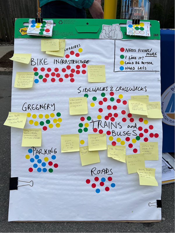
Source: Boston Region MPO Staff
Figure 3 represents data collected from approximately 300 individuals at the Wake Up the Earth Festival and the City of Boston’s Open Streets Dorchester event via the sticker activity depicted in Figure 2. Across the board, participants voted to fix or expand all types of infrastructure. This was especially true for bicycle infrastructure, sidewalks and crosswalks, and trains and buses, where a vote to fix or add more yielded more than 50 percent of the total votes for each respective category; participants also overwhelmingly voted for less parking (80 percent). Many participants specifically noted the importance of separated bike lanes, improvement to sidewalk infrastructure, and reliability of train and bus services.
Figure 3
Transportation Sentiment Sticker Activity Data Collected from Wake Up the Earth Festival and Boston Open Streets Dorchester
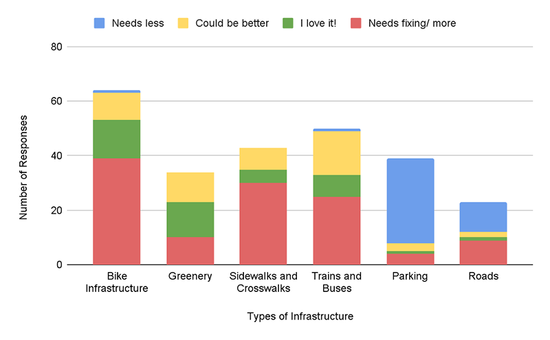
Source: Boston Region MPO Staff
The results of this activity, and of the other engagement conducted during the TIP public review period, highlight strong public support for the prioritization of resilient multimodal infrastructure where users of all modes of transportation can move safely and comfortably. While these results are not representative of the entire Boston Region MPO’s needs and priorities, this sampling provides a useful snapshot of sentiment about transportation infrastructure funding priorities in the context of the TIP. Staff will continue to collect these data and share results with the MPO board to inform future TIP development cycles.
The MPO also received a total of 34 written comments, letters, and petitions during the TIP public review period. Comments are summarized along with staff responses in Table C-2.
Table C-2
Public Comments Received during the Public Review Period for the Draft FFYs 2025–29 TIP
| Project | Name | Support / Oppose / Request / Concern | Comment or Summary of Comment | Response or Summary of Response |
| Project under consideration in FFYs 2025-29 TIP | ||||
| FFYs 25-29 TIP / pedestrian safety need | Kate Elizabeth MacLean | Concern | "The Rt. 9 intersection at Temple St. and Rt. 9 in Framingham (West Framingham) is an intersection with a grocery store, a CVS, a bank and many apartments and a university nearby. This intersection needs to be converted to a four way crosswalk to prevent hazardous conditions for pedestrians. Please do not put this off. There's a diagram that this committee created showing what is needed." | Thank you for sharing your concerns about pedestrian safety on Route 9 in Framingham. The Boston Region MPO appreciates your engagement and input. Your comment will be shared with the MPO board as a part of its review of the draft TIP on June 6, 2024. During this meeting, it is anticipated that MPO members will vote on the endorsement of the TIP after taking into account the public comments received during the 30 day public review period, which ends on May 22. All MPO meetings are public, and you are welcome to attend the meeting if you would like to do so. An agenda and information about how to join this meeting will be posted to the MPO's meeting calendar. There are not any projects currently programmed on the TIP that address your concern, but the MPO will also consider your comment in our continuous collection and assessment of transportation needs around the Boston region. Safety is a top priority for the MPO, and feedback about specific safety issues helps us determine priorities for future study and project funding. To continue the conversation, I encourage you to share your concerns with Framingham planning staff, and follow the MPO's Vision Zero Action Plan as we develop strategies to eliminate fatalities and serious injuries on our roadways and improve safety for people walking and biking. |
| FFYs 25-29 TIP, investment priorities | Rufino Velazquez | Concern | "Thank you for sharing this draft plan. Please continue to divest from highways and roads and invest in better transit and alternative modes of transportation and pedestrian safety. Our cities are already overbuilt for cars, and further investment needs to be made into alternatives and protecting our most vulnerable users." | Thank you for sharing your comments… The investments the MPO makes through the TIP each year are guided by the goals established in our long-range transportation plan for the region, which include safety, equity, resilience, mobility and reliability, access and connectivity, and clean air and healthy communities; the MPO is committed to funding projects that create safe and accessible off-street travel options and connections for pedestrians and bicyclists, improve public transit, reduce congestion and pollution, and support equitable mode shift. |
| FFYs 25-29 TIP, Holliston- Intersection Improvements at Rt 16 & Whitney St [Design Only] and Project #613477 (MassDOT) Holliston-Linden St Improvements at Robert Adams Middle School (SRTS) | Christina Hein | Support | "I am writing as a resident in full support of the two listed projects for the Town of Holliston, the Washington and Whitney intersection re-design and the Linden Street SRTS multi-use path. Both of these projects will result in significant improvements to safety and access for all road users to a degree not seen in many years.” | Thank you for sharing your comments on the Town of Holliston projects programmed in the draft federal fiscal years (FFY) 2025-29 Transportation Improvement Program (TIP) and the expected improvements from these projects… |
| FFYs 25-29 TIP, Holliston- Intersection Improvements at Rt 16 & Whitney St [Design Only] and Project #613477 (MassDOT) Holliston-Linden St Improvements at Robert Adams Middle School (SRTS) | Cynthia Listewnik | Request/ Concern | Please consider funding for the following projects to improve safe access in Holliston. Thanks. Project 1 - Linden Street multi-use path improving an existing safe route to school and providing protected access for people who bike and walk from Washington Street to the Woodland Street school campuses and the rail trail. Project 2 - Washington and Whitney Street intersection redesign to address conflict among all road users, including a trail crossing, commuting passenger vehicles and heavy industrial vehicles accessing the adjacent industrial park and transfer station." | Thank you for sharing your comments on the Town of Holliston projects programmed in the draft federal fiscal years (FFY) 2025-29 Transportation Improvement Program (TIP) and the expected improvements from these projects... |
| FFYs 25-29 TIP, 608954 - Weston- Reconstruction on Route 30 | Jonathan Buchman | Support | "I'm a resident of Weston for 27 years and I'm also a Builder / Developer in town. That said, the proposed Route 30 roadway improvement and multi use walking / biking / running project will be a huge benefit to not only Weston residents but also to other surrounding towns and Massachusetts residents that use it daily for commuting along this 3.7 mile stretch. It will connect all towns from Wayland / Natick through Weston and Newton into Boston with a safe way for bikers, walkers and runners to use without the alternative, which is to use the existing very busy roadway for cars, trucks etc only. Please approve the funding for this project asap and lets improve Massachusetts for all citizens." | Thank you for sharing your comments... MPO staff will continue to work with our partners at the Town of Weston and MassDOT on this effort and are also working with neighboring communities to advance work to further advance the safety and accessibility of the regional Route 30 corridor. |
| FFYs 25-29 TIP, 608954 - Weston- Reconstruction on Route 30 | Anne Donahue | Oppose | “We are opposed to additional funding for the design and engineering of a shared use bicycle path along Route 30 in Weston. “There are no bikers on route 30. If people want to use bikes they should use the bike paths that they insisted on. The roads are for motor vehicles. END OF STORY!! Roads=cars/trucks. Bike Paths=bikes. We have cold and inclement weather 9 months a year and NO ONE is riding bikes. Stop the nonsense of these ridiculous bike lanes.” | Thank you for sharing your comments… MPO staff have been working closely with MassDOT and the Town of Weston in considering these comments in the project development process. |
| FFYs 25-29 TIP, 608954 - Weston- Reconstruction on Route 30 | Ken Skudder | Support | “I wanted to write to you to express my support for the Rt 30 shared use path. I have a friend who lives in Weston right near where this path will be. We both enjoy riding bicycles, and if this path is completed we will be able to do more bike rides that start and/or end in Weston. That'll be pleasant for us, and will also be good for Weston, since we usually get some food and/or coffee before or after a bike ride, which will mean more business for local Weston businesses. This path will also enable people to walk and bike more for transportation, which has huge health and happiness benefits, and helps the planet too. I believe it is a vocal minority who oppose the path, and their arguments against it lack substance (they appear to consist mostly of nonsensical fear mongering and NIMBYism). I hope that construction of this shared use path, which will be such an asset, will not be blocked by these flimsy objections.” | Thank you for sharing your comments… MPO staff will continue to work with our partners at the Town of Weston and MassDOT on this effort, and are also working with neighboring communities to advance work to further advance the safety and accessibility of the regional Route 30 corridor. |
| FFYs 25-29 TIP, 608954 - Weston- Reconstruction on Route 30 | Emily Hutcheson | Support | "I’m very much in favor of the shared use path through Weston on Rt. 30. As a life- long 75-year-old resident, I’ve seen lots of changes over the years and know the value of good projects like this one that connect people in different neighborhoods and towns. I live next to the Mass Central Rail Trail and take daily advantage of it, riding or walking for almost all of my errands, and to walk with friends. What a gift it is to have a safe way to be outdoors biking and walking rather than having to use a car! I’m hoping the people along Rt 30 will know the same gift with the completion of their shared use path. The anonymous group, Focus on Weston, is spreading misinformation about the path that is reminiscent of the NIMBY fear that stopped the Rail Trail 25 years ago. May that not prevail at Town Meeting this time. Please know lots of us are working for the success of this project.” | Thank you for sharing your comments on the Town of Weston's Route 30 project, which is funded in the draft federal fiscal years (FFY) 2025-29 Transportation Improvement Program (TIP)… |
| FFYs 24-28 TIP Project #609204 Belmont Community Path | Aleida Leza | Oppose | Letter in opposition to Belmont Community Path Full letter available in Compiled Public Comments Document. | Thank you for passing along these letters regarding the Belmont Community Path Project… |
| FFYs 25-29 TIP, 608954 - Weston- Reconstruction on Route 30 | Marga Hutcheson | Support | “I'm writing in strong support of the proposed shared use path on Rt 30 in Weston (Project File No. 608954). I'm a biker, runner, and walker for both transportation and recreation. (I'm 37. My husband and I live in Weston and don't have a car, so about 85% of our trips outside of the house are on foot or bicycle, 10% are via borrowing my parents' car, and 5% are public transportation.). I strongly believe that we need to invest in accessible recreation/active transportation infrastructure in order to give people of all ages and abilities the ability to enjoy being outside and to get places. The shared use path would do this. I hear you may be getting a number of emails against the shared use path, many of them prompted by outreach by a shadowy/sketchy completely anonymous group called ""Focus on Weston"" that is spreading inaccurate information about the path. I believe more people in Weston are in favor of the path than against. (It's easier to get people riled up to be against something than to be for it.) I'm writing to you as someone who is strongly in favor of a shared use path (and the overall Rt 30 redesign.) [Commenter provided a list of “pros" for the project including emissions reductions, ADA compliance, safety, and intersection design. Expressed some concern over tree removal but noted that many of the trees were already dead and their removal for the purpose of the project was better than for single family housing.]" | Thank you for sharing your comments on the Town of Weston's Route 30 project, which is funded in the draft federal fiscal years (FFY) 2025-29 Transportation Improvement Program (TIP)… |
| FFYs 25-29 TIP, 608954 - Weston- Reconstruction on Route 30 | Joel Angiolillo | Oppose | “An anonymous email went out to Weston residents asking them to oppose the Route 30 reconstruction project. (The full text is below.) I would like to speak for the future users, over many generations, of a multi-use path along route 30. Facts: Currently there is no safe way to ride or walk east-west from Wayland/Natick to Waltham/Newton. Route 117, Route 20 and Route 30 are all highly bike/pedestrian unfriendly with no end-to-end sidewalks or bike lanes. Only the most confident bike riders would ever attempt to ride one of these roads. There are no pedestrians using these roads today. Several inflammatory statements were made in the anonymous email (full text below): The proposed design is specifically opposed by American Association of State Highway Transportation Officials (AASHTO) This is not true. The proposed design requires massive removal of trees and relocation of historic stone walls "massive removal" = about 50 healthy trees, while MADOT will be planting 2 trees for each removed. (In any case, the proponents seem to be ok with a 5' sidewalk, just not a 10' multi-use path. The 5' sidewalk would require the removal of about as many trees. The scope of the project changed from a sidewalk to a shared use bicycle path. This is true. But it is in response to the new Complete Streets guidelines. The scale and design of the current proposal accommodates the requirements of Mass DOT, not the betterment, safety, or needs of our Town. This is a bike path to nowhere! This is not true. Newton is actively working on the Carriageway. The route 30 bridge across Rt 128 and the Charles is in process. Natick and Wayland have both hope to follow Newton's and Weston's lead.” | Thank you for sharing your comments… MPO staff will continue to work with our partners at the Town of Weston and MassDOT on this effort - and look forward to doing so. The MPO is also working with neighboring communities to advance work to further advance the safety and accessibility of the regional Route 30 corridor, not only in Newton where other projects are currently planned or about to be underway, but also in neighboring communities in the west. |
| FFYs 25-29 TIP, 608954 - Weston- Reconstruction on Route 30 | Alison Barlow | Oppose | “I am a Weston resident. My family moved to Weston in the mid 1970s, I became a Weston homeowner in 2004 and my parents now live with us. I have served on Weston’s Conservation Commission since 2006, but I write to you today with my own separate opinion, not speaking on behalf of the commission. I vehemently oppose the 2-way shared use path that is being proposed along Rte. 30. I oppose it for so many reasons, among them: Weston thought we were initially voting on a 5 ft wide sidewalk, similar to what exists now. Weston should at least be given a chance “turn back the clock” and vote on what is actually being proposed. This stinks. It’s a bait and switch (whether it was intentional or not). Weston did not vote to approve the project as proposed. The approx 50 driveway crossings is ridiculous and is not safe for all of those homes, the bikers trying to cross, etc. Cars travel at 45-50mph, a bike lane along that road, even if separated will make a mess of traffic, cars stopping suddenly if they can’t get into their driveways, etc. The earthworks for this project is ridiculous and will basically make it an ugly corridor running along the mass pike exposing so many homes, cars, bikers, to the massive, currently hidden highway. The number of trees and walls needing to be removed is absurd. So much screening from the massive Mass Pike highway that Weston already has running though it will be lost. The planned Rte 30 crossing (flip flopping the path from one side or Rte 30 to another) will be a mess with traffic. The path will end in Natick, so far from anything. Who will use this??? Commuters to Boston?? That won’t happen for so many months of the year, and really, that means you can’t carpool, pick up kids or groceries. VERY impractical. I’m all for biking, but this is absurd. This isn’t a place where commuting by bike makes sense. It’s not a true suburban space, it’s rural. I would still vote for a 5ft wide sidewalk for walkers and an occasional bike. But the proposed 10’ bike lane will become a mini road for e-bikes, bikes with motors, and mopeds. This has already happened on other similar paths in Massachusetts, making them unsafe for walkers. Even if bikes with engines aren’t allowed, how would this be policed??? It won’t be policed, so it shouldn’t be built. Total costs are nowhere near close to being defined. I’m happy to discuss this or take part in any conversations on this matter. I hope my opinion is considered." | Thank you for sharing your comments… MPO staff have been working closely with MassDOT and the Town of Weston in considering these comments in the project development process, and will continue to do so. |
| FFYs 25-29 TIP Project #605857 Norwood Intersection Improvements at Rt 1 & University Ave/Everett St | Joseph Collins | Support | "Please accept this public comment concerning the "Intersection Improvements at Route 1 & University Avenue/Everett Street - 605857" project. I am writing to support the MPO's recommendation to fund this project fully in FY2025 with a construction start date of the beginning of FY2026. This project has been pushed back several times, and I am happy to see that it will finally receive 100% of its funding next fiscal year rather than split the funding between FY2026 & FY2027 as was the plan in the current TIP. Several of Norwood's largest employers are located on University Avenue and Everett Street. Several of them, including, but not limited to, Metropolitan Cabinets & Countertops, UPS, Amazon, MS Walker, MSI Boston, and Taylor New England, use the Route 1/University Avenue/Everett Street intersection dozens of times each day to access Route 1 and 95. The upgrade to the intersection will provide each company with significant improvement in shipping and receiving operations, significantly improving each company's operational efficiency.” | |
| FFYs 25-29 TIP, Holliston- Intersection Improvements at Rt 16 & Whitney St [Design Only] and Project #613477 (MassDOT) Holliston-Linden St Improvements at Robert Adams Middle School (SRTS) | Carol Bailey | Support | "I am in favor of the 2 Holliston projects. #1 Linden Street: our children need safe access to the schools . Improvements are always needed and welcome. #2- Whitney/Washington St will make that intersection safer for the trail crossing and vehicles in that area , and to have a clear direct safe and steady passage for commercial trucks and vehicles entering and exiting the Industrial Park." | Thank you for sharing your comments on the Town of Holliston projects programmed in the draft federal fiscal years (FFY) 2025-29 Transportation Improvement Program (TIP)… |
| FFYs 25-29 TIP, Holliston- Intersection Improvements at Rt 16 & Whitney St [Design Only] and Project #613477 (MassDOT) Holliston-Linden St Improvements at Robert Adams Middle School (SRTS) | Karen Apuzzo Langton | Concern | "Holliston- Intersection Improvements at Route 16 and Whitney Street [Design Only] Is desperately needed to improve the safe flow of heavy commercial vehicle to and from the main entrance of Lowland Industrial Park at the intersection of Route 16 and Whitney - which services all businesses in the industrial zone. This improvement will assist in stopping heavy commercial cut-though truck traffic using a safe route to school woodland and redirect it to stay on Route 16 @ Whiney where the improvements will make it easier for this traffic to use. HOLLISTON- LINDEN STREET IMPROVEMENTS AT ROBERT ADAMS MIDDLE SCHOOL (SRTS) - this is needed to improve the safety of this area. We have already had an altercation with a car and a student. Linden street is a multi - use road that bisects a safe routes to school." | Thank you for sharing your comments on the Town of Holliston projects programmed in the draft federal fiscal years (FFY) 2025-29 Transportation Improvement Program (TIP)… |
| Malden Rt 60 Improvements Design project (FFYs 25-29 TIP application) | Stephen Winslow | Request/ Concern | "On behalf of the Malden City Council I am writing to call for the FY 2025 – 2029 TIP to include funds to redesign the vital Route 60 Corridor through Malden. Route 60 runs east to west the length of Malden connecting several environmental justice neighborhoods to Malden Center. The purpose of undertaking a redesign of Route 60 will be to allow a project conceived and constructed in the 1970’s as primarily a project to move autos along the corridor to be transformed into a street that re-connects rather than separates our City. The project will further several regional efforts to provide more equitable mobility choices to Malden residents and beyond. In 2022, the MBTA and the City agreed to work on a community connections grant to demonstrate the effectiveness of bus lanes along this corridor. That project with great effort on the part of the MBTA and the City to overcome antiquated traffic signal equipment has resulted in 20% fewer crashes along the corridor while providing more efficient and safe mobility to the bus riders, pedestrians and bicyclists who travel along or cross Route 60. Design funds will allow Malden to plan out and ultimately help fund additional measures to enhance mobility and safety along the corridor. In terms of buses and bicycles, design funds will develop lay-outs to improve intersection operations and the installation a cycle track to connect the Northern Strand Trail to MBTA’s Malden Station. New lay-outs will also provide better pedestrian connections along and across the corridor and help reconceive Route 60 as more of an urban boulevard than a 2 to 4-lane suburban highway. The Council has already voted to change zoning along stretches of Route 60 to implement the MBTA Community Housing law. Design funds will ensure that new residential options planned and constructed will ensure transit, walking and bicycling prove to be safe and reliable modes to travel for work, school, shopping and recreation for all residents in Malden." | The MPO appreciates the continued engagement that Malden has had in advancing projects through the TIP and drive to deliver new ones in future TIP cycles. This year's application cycle was marked by a broad and diverse array of competitive projects that exceeded the MPO's capacity and funding to support. The MPO voted to utilize its resources to support municipalities that had not had access to TIP funding in some years, and in some cases decades. The pilot funding for project design in the FFYs 2025–2029 TIP may serve as a sound foundation for a greater number of communities to advance new projects in future TIP cycles, while enabling stakeholders to learn from this pilot experience and ensure this execution is done successfully. We will continue to work with the City to ensure that its future transportation needs, commensurate with the city's demonstrated intention to expand safe access to housing, commerce, and recreation, can be met through the best funding mechanisms available. |
| FFYs 25-29 TIP, several projects | Jason Palitsch | Support/ Concern | Letter regarding several TIP projects Full letter available in Compiled Public Comments Document. | The MPO will continue to collaborate with regional stakeholders, like the 495/MetroWest Partnership, to advance regional priority projects through MPO funding programs. Staff are collaborating around the identification of such projects for both the TIP and Long Range Transportation Plan, and would be happy to discuss and investigate the I-495/Route 9 project further. Regarding delayed projects, the MPO and MassDOT will work with the municipal project proponents to keep these much-needed projects on track. I am pleased to note that, in the case of Project 610722 - Acton, Boxborough, and Littleton: Pavement Preservation on Route 2, the project's absence from the FFYs 2025–29 TIP is because it has been accelerated out of that five year timeframe into FFY 2024, and was advertised for construction bids this past March 30th. |
| FFYs 25-29 TIP, Swampscott Rail Trail | Kimberly Nassar | Oppose | Letter in opposition to Swampscott Rail Trail project Full letter available in Compiled Public Comments Document. | Thank you for passing this along, I'm confirming receipt here. We appreciate your feedback on the Swampscott Rail Trail project and will ensure that your letter is shared with the MPO board during its review of the draft TIP on June 6, 2024 |
| Malden Rt 60 Improvements Design project (FFYs 25-29 TIP application) | Malden Congressional Delegation (State Sen. Jason Lewis, State Reps Steven Ultrino, Kate Lipper- Garabedian, Paul Donato | Request/ Concern | Letter in support of Malden Rt 60 Improvements Design project (request for programming) Full letter available in Compiled Public Comments Document. | The MPO appreciates the engagement that the City of Malden and its stakeholders have had in advancing projects through the TIP and interest in furthering a safe, accessible, and multimodal transportation network for all. This year's initial design funding pilot application cycle was competitive, with fifteen applications received, of which the MPO could only support a fraction. The MPO hopes that the projects selected will serve as a foundation for a greater number of communities to advance new projects in future TIP cycles, while enabling stakeholders to learn from this pilot experience. While not all applications were funded, those that were not demonstrate the significant demand for continued investment by the MPO in this critical area. We will continue to work with the City and our partners at MassDOT, the MBTA and MAPC to ensure that future transportation investment will address the needs that community members have expressed. |
| Project #611982 – Medford– Shared- Use Path Connection at the Route 28/Wellington Underpass | Karl Alexander | Support | “"I’m writing on behalf of the Mystic River Watershed Association (MyRWA), whose mission is to protect and restore the Mystic River and its tributaries. Our vision is a healthy, vibrant, and resilient Mystic River Watershed for the benefit of all our community members. MyRWA works with residents to protect water quality, restore important habitats, build climate resilience, transform parks and paths, inspire youth and grow community. Our Mystic Greenways vision is bringing to reality a 25- mile, high-quality network of greenways for active transportation and recreation, enhanced climate resiliency, and improved physical and mental health outcomes for residents of our watershed and Commonwealth. We are delighted that the Boston Region MPO has voted to fund Project #611982 – Medford– Shared-Use Path Connection at the Route 28/Wellington Underpass ($5,509,294) in FFY25, hich was previously funded under MassDOT's statewide highway program. The underpass, a project which is included in our greenways vision and one that we helped to spearhead in ollaboration with DCR, MassDOT and the City of Medford, will provide a vital connection for the region's greenways and eliminate a dangerous at-grade crossing of State Route 28. Projects like this will help to reduce the region's reliance on single occupancy vehicles for everyday commuting needs.” | Thank you for sharing your comments on the Medford Shared- Use Path Connection project programmed in the draft federal fiscal years (FFY) 2025-29 Transportation Improvement Program (TIP)… |
| Project #609204 Belmont Community Path, FFYs 2025–29 TIP | Paul Cobuzzi | Concern | “I am writing to you because I have reservations concerning the Belmont Community project# 609204 proximity to the live MBTA Fitchburg Commuter rails. I believe the planned distance is 10.5 feet from the northern most rail. There have been so many changes to the specifications that who knows what to believe. The proposed fence(steel or titanium or whatever) could be cut with a diamond blade. Yes, they sell them for hacksaws too in hardware stores. Right now, the MBTA keeps the number of ‘trespassers’ to a minimum, keeping the home break ins, homes Invasions, assorted damage and home burglaries to a minimum. What will happen when the machines that plow the tracks and the paths, pack the snow and ice against the fences and the accumulation fills in between the chain links and freezes, then bends the fence so heavily that the fence posts lean under the weight and snaps the fasteners that hold the chain links to the posts? The town will do nothing. What will happen when holes are cut by the trespassers(adults or students) seeking shortcuts across the live tracks because no one will walk 1/4 mile around to the tunnel when they can just short cut thru the fence? The town will do nothing. The Town has repeatedly stated they will not maintain this fence or any other part of the path. They will not patch the holes or repair any other damage. The Windbrook public grammar school located north of the MBTA tracks graduates between 80 to 100 students per class, depending on the year. Most of them probably will travel south thru the proposed new tunnel to attend the new High school/Middle school each morning. An equal number could travel north in the afternoon. That could be as many as 700 students each way, for grades 6 thru 12, that is 1,400 trips more or less daily. The CPPC has estimated as many 1000 users per day each way, East to West and West to East. That is another 2000 users daily. The CPPC wish to make project# 609204 into a playground. They have not called it that yet. But, they will be encouraging our children to play up there by adding lights and benches. That technically makes it a park. When you increase the population(trespassers), you increase the crime and the accident rate. On May 13, 2024, Boston news WCVB channel 5 reported the headline: “Two people dead after being hit by MBTA Commuter Rail train”. This happened on the Framingham/Worcester line. Part of the article read “The tracks run parallel to a bicycle park for children. Just thought I would give you a heads up!!! Thank you añd sincerely.” | Thank you for sharing your comments on the Town of Belmont's Community Path project… |
| MBTA funding, FFY 2024–28 TIP Amendment 7 | Joel Schwartz | Concern | The systemic lack of maintenance on MBTA trains and tracks is how it got into the disaster it is at the moment. The allocation of 0 dollars for maintenance in out years in this plan is a recipe for disaster. I know money is tight, but you must reallocate some money to maintenance. | |
| FFYs 25-29 TIP, 608954 - Weston- Reconstruction on Route 30 | Rebecca Mercuri and Lou Mercuri | Concern/ Request | "We are writing regarding the Route 30 Reconstruction Project (#608954) in Weston. In the draft 2025-2029 FFY TIP, the project is placed in the FFY 2027 budget year. In May 2023, as part of the TIP comment period, 110 residents signed a letter of concern regarding this project, with the primary concern being the proposed implementation of a two-way shared use path. In spite of our best efforts to engage the Town and its consultant on specific design alternatives to the proposed shared use path, the 25% design has not changed since the design direction was communicated in 2019. There has been little to no meaningful engagement to understand and fully consider design alternatives with the 100+ property owners who are directly impacted by the project. In recent months statements have been made by Town officials and others familiar with the project, that the Route 30 Reconstruction will not be funded by MassDOT and the Boston MPO unless the two-way shared use path is included, as proposed, consistent with the 25% design submission. To provide clarity on this topic, we respectfully ask for your guidance on the following questions: Can you confirm or deny that funding for the Route 30 Reconstruction TIP project will be denied, and the project will be dropped by MassDOT, if the Town of Weston does not support the currently proposed two-way shared use path along the entire 3.7-mile length of Route 30 in Weston? Is it true that no alternative options, such as separated bike lanes or single-direction shared use paths on each side of the road, will be considered or accepted for the project? We look forward to hearing from you on this." | We understand and appreciate the continued engagement that Weston Residents have had as this project has advanced. The Boston Region MPO has worked closely with the Town of Weston and MassDOT as the project has progressed to relay the feedback we have received from the public. It is our understanding that the Town and its consultants have advanced design funding to further the Route 30 project thanks to a successful vote at a recent Town Meeting. This funding will allow for the project to continue beyond the 25% design stage, and its our understanding that the town and MassDOT will continue to engage the public around the project as it progresses. Given that the Town has funding for a design that is not only consistent with the MPO's goals and objectives, but mirrors investments being made by the City of Newton and MassDOT to the east, is encouraging follow-on work from Natick at the western edge of the project, and meets MassDOT's design requirements for safety and accessibility, the project is not at risk for removal from the TIP. MPO staff will continue to work with the Town and MassDOT to ensure that this project and the design it will implement deliver the best possible outcome for users of this significant regional connector. |
| Project #609204 Belmont Community Path, FFYs 2025–29 TIP | UNKNOWN (A W) | Concern | “I am writing to express serious concerns regarding Project #609204 the proposed Belmont Community Path. The extremely pertinent backstory is that the town of Belmont hired The Pare Corporation to conduct a feasibility study to decipher the best route of the path. The Southside of the train tracks was the selected route by the unbiased professional corporation tasked with deciding the best placement. Additionally, abutters to this proposed Path have raised countless concerns and vehemently opposed this path being placed on the north side of the tracks behind their homes. Also countless neighborhood residents submitted letters of opposition in 2021 when previous comment periods were open. However, the town of Belmont has continuously disregarded the independent expert findings of the Pare Corporation, the objections of the abutters, and disapproval of members of the neighborhood and have forced the selected path route on the north side of the tracks. This project should not be funded as currently proposed on the north side. Please allow the impartial and rightfully sought after route of this path to be placed on the south side of the tracks or on another route as many other routes have been proposed. If the town continues to improperly fight for the less feasible option, contrasting the very experts they paid to decide the best route, please do not fund this. The north side is not the right side. Other pertinent factors are that the abutters were promised on multiple occasions to have a say in the fencing between their homes and the Path. There was even an advertised abutters walk in April 2024 for feedback from the neighborhood on their desired fencing. Now it seems to have all been for show, as a four foot post and rail fence dividing this path from homes has somehow been decided. The very people who will be forced to live with thousands of people traveling directly behind their homes have been mislead on multiple occasions. This project is expected to be funded by MassDot- how can a project that has so much opposition and contradictions to expert findings be funded? There has been zero accountability within this project. Please consider how unfair and wrong this is. A last Point so that you are fully aware of a grave fault in the current proposed Path is that there is a building standing in the way of the North side route of the path. Safety guidelines require a minimum amount of feet between the live railroad tracks and the path. The occupied building makes it so that the required bare minimum distance of necessary separation does not seem achievable given the minimum path width. Pedestrian safety should be of the utmost concern to everyone. How could the proposed path be placed here. Not having the minimum square footage separating the live rail and the path is a direct violation of known laws and rules meant to keep people safe. This route appears inoperable for a path. Also abutters should not be mislead, the serious lack of accountability is obvious. Building the path on the expert decided south side of the tracks solves these concerns. The feasibility study has been paid for and is complete. The clear and concise findings are in writing and there is no way to deny what the legitimate answer is- this path should have been presented to MassDot on another route- not the north side. Please do not fund this deceptive project until honesty and transparency prevail. All paths lead to not placing this path on the north side of the tracks given the safety concerns and the objections of abutters. How and why have all these issues been completely ignored?” | Thank you for providing comment on the Belmont Community Path project, which is funded in FFY 2026 of the Transportation Improvement Program… |
| Malden Rt 60 Improvements Design project (FFYs 25-29 TIP application) | Mayor Gary Christenson | Request | Letter in support of Malden Rt 60 Improvements Design project (request for programming) Full letter available in Compiled Public Comments Document. | We greatly appreciate the strong engagement that the City of Malden, including Mayor Christenson and others, have had in this year's TIP Development Cycle and will be sure to advance all comments received on the FFYs 2025–29 TIP (and its projects) to the MPO board for their consideration. In addition to advancing these comments, MPO staff will also continue to track the Route 60 project within the TIP Universe of Projects as we recognize its role as a priority corridor not only for the City but also for neighboring communities as well. We look forward to continuing to work with stakeholders in the area to try and advance projects that will deliver the outcomes requested by the many members of the Malden community that we have heard from. We also appreciate the city's flexibility and willingness to adjust the scope of work to try and meet some of the resource constraints that influenced not only the selection of design projects this TIP cycle, but also construction projects as well. |
| Malden Rt 60 Improvements Design project (FFYs 25-29 TIP application) | Allison Durak | Concern | “Dear Chair Mohler and Members of the Boston MPO: It has come to my attention that funds have been shifted away from the redesign of the Route 60 Corridor here in Malden. I have seen that Malden has invested in beautifying and creating safe spaces for its locals in recent years. Does this not include Route 60? I have attended town hall meetings here in my hometown. I know Route 60 is a pain point, so why doesn’t the city move forward with its plans for welcoming town structures and roads? As a mother, I am concerned the city isn’t taking enough action for my son’s safety especially when I expected one thing and there are now plans to alter course. Please do not remove funds from the redesign of Route 60 Corridor or help me understand what is more important and why you have changed your mind. Let’s keep and include the funds for the Route 60 Corridor redesign in FY 2025 - 2029 if not for you, for my son. He can’t drive a car. He’s still a pedestrian.” | Thank you for sharing your comments…The Boston Region MPO piloted a new funding program in the FFYs 2025–29 TIP cycle to provide funding to municipalities to design transportation projects. The City of Malden, among many other communities, submitted applications for funding through this program, one of them being for the Route 60 corridor and another for Commercial Street. Given the competitive nature of this new program and the constrained funding and staff resources on hand to facilitate it, only a fraction of the applications received by the MPO could be funded. Given this is a pilot program, the MPO hopes that stakeholders - including the MPO and other project delivery partners - can learn from this experience to create a broader and more long term opportunity for municipalities to utilize. The number of applications the MPO received certainly demonstrates the demand that communities in the Boston Region have for design funding support. While the Route 60 project is not currently on the TIP, as it did not advance through those initial funding rounds, the MPO will continue to work with the City of Malden and other communities that were not selected this year to try and advance these worthy projects. |
| Swampscott Rail Trail Project #610666 (FFYs 2025–29 TIP Project in FFY 2028) | Maura Carroll | Oppose | Letter in Opposition about Swampscott Rail Trail Project 610666. Full letter available in Compiled Public Comments Document. | I have added your comment letter to the file. Thank you for passing it along. We will be certain to advance this comment and others we have received to the MPO Board for their consideration at the June 6 MPO Board meeting, during which it is anticipated that members will vote on the endorsement of the FFYs 2025–29 TIP. |
| Route 30 Reconstruction project in Weston #608954 | Rebecca Mercuri, Lou Mercuri, Kayla Mercuri, Lenore Zug, Lobel David Robbins, Matt Lane, Jessica Moy, Jon Moy, James Dwinell III, Ellen Dwinell, Mohammed Hassan, Thamina Hassan, Constance Moore, Sheila Smallwood, Laurie Endlar Lee, Paul Davenport, Aviva Jeruchim, William Davenport, Joan Marion Parrish, Susan Zacharias, Jim Kappel, Nancy Kappel, Henry Fizer, Gabriel Fizer, Carol Fizer, Sarah Butera, Steve Butera, Artemis Willis, Nagy Mikael, Lillian Mikael, Michael Lee, Doreen Mirley, John Mirley, Victoria Huber, Tony Brooke, Alison Barlow, Janet K. Fronk, Michele Schuckel, John R. Barlow, Julia M. Barlow, Joan Kertis, Katherine A. Barlow, Barbara Gilman, Richard Gilman, Neil Diver, Katherine Diver, Frank Caine, Becky Ames, Paul Donahue, John McDonald, Janice Kaplan, Barbara Baker, Robert Froh, Richard Flynn, Laura Schiff Bean, Warren Pinckert, Beverly Watson, Steve Watson, Sheila Weinstock, Norman Weinstock, Linda Harding, John Harding, Barbara Bush Meissner, Cody Meissner, Natty MacArthur, Andi Shaw, Doug Shaw, Susan Schaefer, Christian Halby, Marty Broff, Jenifer Lipson, Freya Bernstein, Louis Grossman, Amy Gerson, Bruce Pastor, Richard Tedlow, Donna Staton, Barbara Bowen, Kathie Collman, Bob Collman, Nancy Lukitsh Linda Davidson Barry Davidson Duncan Warden Gail Warden, Margaret Ewald, Laraine Levy, Jeff Levy, Al Aydelott, Richard DiVito, Margaret Griner, Paul Griner, Tom Keery, Laura Keery, Gary Lee, Rachel Stewart, Janice Glynn, Rochelle Nemrow, John Sallay, Anne Sallay, Hugh Pearson, Gustav Christensen, Bette Pearson, Vivake Pearson, Paul Brontas, Richard Trant, Sherwin Greenblat, Joyce Flaherty, Richard K Babayan, Sonya Nersessian, Lawrence Lee, Nicole Lee, Alexandra Lee, Madeline Lee, Charlotte Lee, Averill Bromfield, Mary Bromfield, Jonathan Chase, Laura Dixon, Clarence Dixon, Doug Garron, Lorna Garron, Jennifer Garron, Amy Silverstein, Roxanne Ferreiro, Jack O’Donnell, Andrew Tamoney, Susan Tamoney, Elizabeth Messina, Mark Messina, Fernanda Bourlot, Barbara Fullerton, Burt Fullerton, Diana Chaplin, Nina Danforth, Clifford Abrecht, Michele Abrecht | Oppose | Petition in Opposition about Route 30 Reconstruction project in Weston #608954. Full petition available in Compiled Public Comments Document. | Thank you for passing this along. We are in receipt of your letter and will make sure it is incorporated into the list of other comments that we have received around the project, which will be shared with our MPO members as we anticipate a vote to endorse the Draft FFYs 2025–29 TIP on June 6. |
| Route 30 Reconstruction project in Weston #608954 | Neil Diver, Katherine Williams, Frank Caine, Becky Ames, Paul Donahue, John Mc Donald, Lise Revers, Janice Kaplan, Barbara Baker, Robert Froh, Richard Flynn, Laura Schiff Bean, Warren Pinckert, Beverly Watson, Steve Watson, Sheila Weinstock, Norman Weinstock, Linda Harding, John Harding, Barbara Bush Meissner, Cody Meissner, Natty MacArthur, Andi Shaw, Doug Shaw, Susan Schaefer, Nolte Circle, Christian Halby, Marty Broff, Jenifer Lipson, Freya Bernstein, Louis Grossman, Amy Gerson, Bruce Pastor, Richard Tedlow, Donna Staton, Barbara Bowen, Kathie Collman, Bob Collman, Nancy Lukitsh, Linda Davidson, Barry Davidson, Duncan Warden, Gail Warden, Margaret Ewald, Laraine Levy, Jeff Levy, Al Aydelott, Diana Chaplin, Richard DiVito, Maragaret Griner, Paul Griner, Tom Keery, Laura Kerry, Gary Lee, Janice Glynn, John Sallay, Anna Sallay, Rachael Stewart, Rochelle Nemrow | Oppose | Petition in Opposition about Route 30 Reconstruction project in Weston #608954. Full petition available in Compiled Public Comments Document. | Thank you for passing this along and providing feedback on the FFYs 2025–29 TIP. We will make sure that your feedback is considered alongside other comments received around both the Route 30 project and the broader TIP… |
| FFYs 24-28 TIP Project #609204 Belmont Community Path | Patrice Garvin | Support | Letter in support to Belmont Community Path Full letter available in Compiled Public Comments Document. | |
| TIP evaluation criteria | Michael F. Zullas | Concern | Letter regarding TIP evaluation criteria and MBTA Communities Act compliance penalties Full letter available in Compiled Public Comments Document. | |
| TIP process, content, equity considerations | Regional Transportation Advisory Council | Support/ Concern | Letter in regarding TIP process, content, and equity considerations Full letter available in Compiled Public Comments Document. | |
| TIP content | MBTA Rider Oversight Committee | Support | Letter in support of projects programmed in FFYs 2025-2029 TIP Full letter available in Compiled Public Comments Document. | |
The following formal comment letters were received during the development of the FFYs 2025-29 TIP:
These letters are available on the June 6, 2024, MPO meeting calendar, in a document entitled FFYs 2025-29 TIP Public Comments Compiled.
Appendix D provides information about the geographic distribution of federal highway funding in the Boston region in the federal fiscal years (FFYs) 2025–29 Transportation Improvement Program, as well as for all years since 2011. It includes the distribution of the Boston Region MPO’s Regional Target Program funding (the MPO’s discretionary funding) and funding for projects and programs prioritized by the Massachusetts Department of Transportation. Funding amounts shown include the state’s matching funds that leverage the available federal funds.
Figures D-1 through D-4 summarize the distribution of the MPO’s Regional Target Program funding and all federal highway funding by subregion. Funding is shown for the time period covered by this TIP (FFYs 2025–29) and over a longer time horizon (FFYs 2011–29). Table D-1 shows the breakdown of this data for each municipality in the Boston region for FFYs 2025–29.
The analysis presented here provides details about how the MPO has allocated its federal transportation highway dollars across its geographic region by showing which municipalities and areas of the Boston region have received highway funding for the construction of transportation projects. This data was first compiled for FFYs 2008-13 in response to the Boston Region MPO’s 2014 Certification Review by the Federal Highway Administration and Federal Transit Administration.
Figure D-1
Distribution of Regional Target Funding by Subregion (FFYs 2025–29)

Subregions: ICC = Inner Core Committee. MAGIC = Minuteman Advisory Group on Interlocal Coordination. MWRC = MetroWest Regional Collaborative. NSPC = North Suburban Planning Council. NSTF = North Shore Task Force. SSC = South Shore Coalition. SWAP = SouthWest Advisory Planning Committee. TRIC = Three Rivers Interlocal Council.
Source: Boston Region MPO.
Figure D-2
Distribution of All Federal Highway Funding in the Boston Region by Subregion (FFYs 2025–29)

FFY = Federal Fiscal Year.
Subregions: ICC = Inner Core Committee. MAGIC = Minuteman Advisory Group on Interlocal Coordination. MWRC = MetroWest Regional Collaborative. NSPC = North Suburban Planning Council. NSTF = North Shore Task Force. SSC = South Shore Coalition. SWAP = SouthWest Advisory Planning Committee. TRIC = Three Rivers Interlocal Council.
Source: Boston Region MPO.
Figure D-3
Distribution of Regional Target Funding by Subregion (FFYs 2011–29)

FFY = Federal Fiscal Year.
Subregions: ICC = Inner Core Committee. MAGIC = Minuteman Advisory Group on Interlocal Coordination. MWRC = MetroWest Regional Collaborative. NSPC = North Suburban Planning Council. NSTF = North Shore Task Force. SSC = South Shore Coalition. SWAP = SouthWest Advisory Planning Committee. TRIC = Three Rivers Interlocal Council.
Source: Boston Region MPO.
Figure D-4
Distribution of All Federal Highway Funding in the Boston Region by Subregion (FFYs 2011–29)

FFY = Federal Fiscal Year.
Subregions: ICC = Inner Core Committee. MAGIC = Minuteman Advisory Group on Interlocal Coordination. MWRC = MetroWest Regional Collaborative. NSPC = North Suburban Planning Council. NSTF = North Shore Task Force. SSC = South Shore Coalition. SWAP = SouthWest Advisory Planning Committee. TRIC = Three Rivers Interlocal Council.
Source: Boston Region MPO.
Table D-1
Federal Highway Programming for Municipalities in the Boston Region (FFYs 2025–29)
| MPO Municipality | Subregion | Community Type | Pct Pop. | Pct Empl. | Percent Federal Aid Roadway Miles (2016) | Regionally Prioritized Target Funding (FFY 2025-29) | Percent Regionally Prioritized Target Funding | State Prioritized Funding | Percent State Prioritized Funding | Total Funding (Regionally Prioritized and State Prioritized) | Percent Total Funding (Regionally Prioritized and State Prioritized) | FFYs 2011-2029 (Target) | FFYs 2011-2029 (State) | FFYs 2011-2029 (All) | Percent FFYs 11-29 Target | Percent FFYs 11-29 State | Percent FFYs 11-29 All |
| Boston | Inner Core | Inner Core | 20.1% | 33.3% | 11.1% | $133,516,870 | 20.0% | $294,419,621 | 18.8% | $427,936,491 | 19.1% | $294,419,621 | $427,936,491 | $196,935,577 | 18.75% | 19.12% | 19.12% |
| Somerville | Inner Core | Inner Core | 2.4% | 1.5% | 1.2% | $90,588,127 | 13.6% | $231,698,858 | 14.8% | $322,286,985 | 14.4% | $231,698,858 | $322,286,985 | $184,056,811 | 14.76% | 14.40% | 14.40% |
| Hopkinton | SWAP | Developing Suburb | 0.6% | 0.5% | 1.0% | $0 | 0.0% | $72,273,687 | 4.6% | $72,273,687 | 3.2% | $72,273,687 | $72,273,687 | $11,346,584 | 4.60% | 3.23% | 3.23% |
| Beverly | NSTF | Regional Urban Center | 1.3% | 1.2% | 1.2% | $0 | 0.0% | $50,994,954 | 3.2% | $50,994,954 | 2.3% | $50,994,954 | $50,994,954 | $38,972,530 | 3.25% | 2.28% | 2.28% |
| Natick | MetroWest | Maturing Suburb | 1.1% | 1.0% | 1.2% | $7,656,912 | 1.1% | $40,355,157 | 2.6% | $48,012,069 | 2.1% | $40,355,157 | $48,012,069 | $30,456,681 | 2.57% | 2.14% | 2.14% |
| Cambridge | Inner Core | Inner Core | 3.5% | 7.1% | 1.8% | $385,456 | 0.1% | $79,586,223 | 5.1% | $79,971,679 | 3.6% | $79,586,223 | $79,971,679 | $45,373,097 | 5.07% | 3.57% | 3.57% |
| Wilmington | NSPC | Maturing Suburb | 0.7% | 1.1% | 1.3% | $37,452,645 | 5.6% | $24,970,700 | 1.6% | $62,423,345 | 2.8% | $24,970,700 | $62,423,345 | $43,894,003 | 1.59% | 2.79% | 2.79% |
| Salem | NSTF | Regional Urban Center | 1.3% | 0.9% | 0.7% | $24,816,586 | 3.7% | $48,182,285 | 3.1% | $72,998,871 | 3.3% | $48,182,285 | $72,998,871 | $35,546,555 | 3.07% | 3.26% | 3.26% |
| Lynn | Inner Core | Regional Urban Center | 3.0% | 1.3% | 1.3% | $54,698,640 | 8.2% | $50,297,024 | 3.2% | $104,995,664 | 4.7% | $50,297,024 | $104,995,664 | $67,071,331 | 3.20% | 4.69% | 4.69% |
| Norwood | TRIC | Regional Urban Center | 0.9% | 1.1% | 1.0% | $27,636,336 | 4.1% | $1,668,001 | 0.1% | $29,304,337 | 1.3% | $1,668,001 | $29,304,337 | $35,588,616 | 0.11% | 1.31% | 1.31% |
| Milton | TRIC | Maturing Suburb | 0.9% | 0.1% | 1.3% | $0 | 0.0% | $28,224,439 | 1.8% | $28,224,439 | 1.3% | $28,224,439 | $28,224,439 | $0 | 1.80% | 1.26% | 1.26% |
| Peabody | NSTF | Regional Urban Center | 1.6% | 1.1% | 1.4% | $15,272,235 | 2.3% | $0 | 0.0% | $15,272,235 | 0.7% | $0 | $15,272,235 | $30,492,095 | 0.00% | 0.68% | 0.68% |
| Chelsea | Inner Core | Inner Core | 1.2% | 0.8% | 0.6% | $21,802,029 | 3.3% | $30,990,670 | 2.0% | $52,792,699 | 2.4% | $30,990,670 | $52,792,699 | $33,695,642 | 1.97% | 2.36% | 2.36% |
| Framingham | MetroWest | Regional Urban Center | 2.2% | 2.1% | 2.5% | $7,107,213 | 1.1% | $20,391,409 | 1.3% | $27,498,622 | 1.2% | $20,391,409 | $27,498,622 | $20,783,343 | 1.30% | 1.23% | 1.23% |
| Brookline | Inner Core | Inner Core | 1.9% | 0.9% | 1.3% | $29,195,267 | 4.4% | $955,021 | 0.1% | $30,150,288 | 1.3% | $955,021 | $30,150,288 | $36,125,793 | 0.06% | 1.35% | 1.35% |
| Watertown | Inner Core | Inner Core | 1.1% | 1.0% | 0.6% | $228,939 | 0.0% | $2,160,000 | 0.1% | $2,388,939 | 0.1% | $2,160,000 | $2,388,939 | $24,747,368 | 0.14% | 0.11% | 0.11% |
| Medford | Inner Core | Inner Core | 1.8% | 1.1% | 1.5% | $5,509,294 | 0.8% | $24,902,223 | 1.6% | $30,411,517 | 1.4% | $24,902,223 | $30,411,517 | $47,361,692 | 1.59% | 1.36% | 1.36% |
| Revere | Inner Core | Inner Core | 1.9% | 0.5% | 1.3% | $875,867 | 0.1% | $75,691,671 | 4.8% | $76,567,538 | 3.4% | $75,691,671 | $76,567,538 | $875,867 | 4.82% | 3.42% | 3.42% |
| Woburn | NSPC | Regional Urban Center | 1.2% | 2.1% | 1.5% | $12,773,511 | 1.9% | $2,282,175 | 0.1% | $15,055,686 | 0.7% | $2,282,175 | $15,055,686 | $42,850,437 | 0.15% | 0.67% | 0.67% |
| Everett | Inner Core | Inner Core | 1.5% | 0.8% | 0.6% | $12,539,448 | 1.6% | $5,059,530 | 0.3% | $16,014,186 | 0.7% | $5,059,530 | $16,014,186 | $40,201,854 | 0.32% | 0.72% | 0.72% |
| Braintree | SSC | Maturing Suburb | 1.2% | 1.3% | 1.4% | $0 | 0.0% | $52,311,757 | 3.3% | $52,311,757 | 2.3% | $52,311,757 | $52,311,757 | $0 | 3.33% | 2.34% | 2.34% |
| Randolph | TRIC | Maturing Suburb | 1.0% | 0.4% | 1.0% | $0 | 0.0% | $7,194,377 | 0.5% | $7,194,377 | 0.3% | $7,194,377 | $7,194,377 | $2,000,000 | 0.46% | 0.32% | 0.32% |
| Quincy | Inner Core | Regional Urban Center | 3.0% | 2.4% | 2.1% | $1,885,353 | 0.3% | $3,221,140 | 0.2% | $5,106,493 | 0.2% | $3,221,140 | $5,106,493 | $11,513,193 | 0.21% | 0.23% | 0.23% |
| Canton | TRIC | Maturing Suburb | 0.7% | 1.1% | 1.1% | $0 | 0.0% | $16,609,548 | 1.1% | $16,609,548 | 0.7% | $16,609,548 | $16,609,548 | $2,386,278 | 1.06% | 0.74% | 0.74% |
| Newton | Inner Core | Inner Core | 2.6% | 2.6% | 2.6% | $0 | 0.0% | $31,179,309 | 2.0% | $31,179,309 | 1.4% | $31,179,309 | $31,179,309 | $18,576,963 | 1.99% | 1.39% | 1.39% |
| Belmont | Inner Core | Inner Core | 0.8% | 0.4% | 0.6% | $20,499,750 | 3.1% | $0 | 0.0% | $20,499,750 | 0.9% | $0 | $20,499,750 | $35,999,864 | 0.00% | 0.92% | 0.92% |
| Lexington | MAGIC | Maturing Suburb | 1.0% | 1.1% | 1.9% | $1,650,000 | 0.2% | $14,019,980 | 0.9% | $15,669,980 | 0.7% | $14,019,980 | $15,669,980 | $6,850,000 | 0.89% | 0.70% | 0.70% |
| Weston | MetroWest | Maturing Suburb | 0.4% | 0.3% | 1.3% | $23,237,516 | 3.5% | $0 | 0.0% | $23,237,516 | 1.0% | $0 | $23,237,516 | $23,237,516 | 0.00% | 1.04% | 1.04% |
| Reading | NSPC | Maturing Suburb | 0.8% | 0.4% | 0.8% | $6,000,000 | 0.9% | $26,089,557 | 1.7% | $32,089,557 | 1.4% | $26,089,557 | $32,089,557 | $16,093,721 | 1.66% | 1.43% | 1.43% |
| Stoneham | NSPC | Maturing Suburb | 0.7% | 0.3% | 0.8% | $205,189 | 0.0% | $6,658,780 | 0.4% | $6,863,969 | 0.3% | $6,658,780 | $6,863,969 | $2,345,081 | 0.42% | 0.31% | 0.31% |
| Waltham | Inner Core | Inner Core | 1.9% | 3.2% | 1.6% | $0 | 0.0% | $0 | 0.0% | $0 | 0.0% | $0 | $0 | $0 | 0.00% | 0.00% | 0.00% |
| Burlington | NSPC | Maturing Suburb | 0.8% | 2.4% | 1.3% | $0 | 0.0% | $13,834,451 | 0.9% | $13,834,451 | 0.6% | $13,834,451 | $13,834,451 | $14,563,174 | 0.88% | 0.62% | 0.62% |
| Hingham | SSC | Maturing Suburb | 0.7% | 0.8% | 1.3% | $28,738,432 | 4.3% | $0 | 0.0% | $28,738,432 | 1.3% | $0 | $28,738,432 | $37,708,939 | 0.00% | 1.28% | 1.28% |
| Wrentham | SWAP | Developing Suburb | 0.4% | 0.3% | 1.0% | $697,500 | 0.1% | $0 | 0.0% | $697,500 | 0.0% | $0 | $697,500 | $697,500 | 0.00% | 0.03% | 0.03% |
| Boxborough | MAGIC | Developing Suburb | 0.2% | 0.2% | 0.4% | $101,660 | 0.0% | $0 | 0.0% | $101,660 | 0.0% | $0 | $101,660 | $101,660 | 0.00% | 0.00% | 0.00% |
| Bellingham | SWAP | Developing Suburb | 0.5% | 0.3% | 0.9% | $8,340,000 | 1.2% | $13,721,814 | 0.9% | $22,061,814 | 1.0% | $13,721,814 | $22,061,814 | $15,054,278 | 0.87% | 0.99% | 0.99% |
| Cohasset | SSC | Developing Suburb | 0.2% | 0.1% | 0.5% | $0 | 0.0% | $0 | 0.0% | $0 | 0.0% | $0 | $0 | $0 | 0.00% | 0.00% | 0.00% |
| Milford | SWAP | Regional Urban Center | 0.9% | 0.9% | 1.2% | $13,548,565 | 2.0% | $3,744,000 | 0.2% | $17,292,565 | 0.8% | $3,744,000 | $17,292,565 | $20,016,509 | 0.24% | 0.77% | 0.77% |
| Dedham | TRIC | Maturing Suburb | 0.8% | 0.8% | 1.1% | $0 | 0.0% | $25,097,925 | 1.6% | $25,097,925 | 1.1% | $25,097,925 | $25,097,925 | $16,090,272 | 1.60% | 1.12% | 1.12% |
| Weymouth | SSC | Maturing Suburb | 1.7% | 1.0% | 1.5% | $0 | 0.0% | $7,275,077 | 0.5% | $7,275,077 | 0.3% | $7,275,077 | $7,275,077 | $25,040,879 | 0.46% | 0.33% | 0.33% |
| Swampscott | NSTF | Maturing Suburb | 0.5% | 0.2% | 0.3% | $8,624,000 | 1.3% | $0 | 0.0% | $8,624,000 | 0.4% | $0 | $8,624,000 | $8,624,000 | 0.00% | 0.39% | 0.39% |
| Middleton | NSTF | Developing Suburb | 0.3% | 0.2% | 0.5% | $0 | 0.0% | $6,487,646 | 0.4% | $6,487,646 | 0.3% | $6,487,646 | $6,487,646 | $0 | 0.41% | 0.29% | 0.29% |
| Danvers | NSTF | Maturing Suburb | 0.8% | 1.3% | 1.5% | $0 | 0.0% | $13,292,606 | 0.8% | $13,292,606 | 0.6% | $13,292,606 | $13,292,606 | $8,836,648 | 0.85% | 0.59% | 0.59% |
| Winchester | NSPC | Maturing Suburb | 0.7% | 0.4% | 0.6% | $0 | 0.0% | $1,786,779 | 0.1% | $1,786,779 | 0.1% | $1,786,779 | $1,786,779 | $1,809,703 | 0.11% | 0.08% | 0.08% |
| Ipswich | NSTF | Developing Suburb | 0.4% | 0.3% | 0.7% | $14,728,698 | 2.2% | $1,693,293 | 0.1% | $16,421,991 | 0.7% | $1,693,293 | $16,421,991 | $15,804,933 | 0.11% | 0.73% | 0.73% |
| Foxborough | TRIC | Developing Suburb | 0.6% | 0.6% | 1.3% | $0 | 0.0% | $20,231,680 | 1.3% | $20,231,680 | 0.9% | $20,231,680 | $20,231,680 | $0 | 1.29% | 0.90% | 0.90% |
| Acton | MAGIC | Maturing Suburb | 0.7% | 0.5% | 1.1% | $0 | 0.0% | $11,266,036 | 0.7% | $11,266,036 | 0.5% | $11,266,036 | $11,266,036 | $15,862,768 | 0.72% | 0.50% | 0.50% |
| Winthrop | Inner Core | Inner Core | 0.6% | 0.1% | 0.3% | $0 | 0.0% | $0 | 0.0% | $0 | 0.0% | $0 | $0 | $6,617,959 | 0.00% | 0.00% | 0.00% |
| Littleton | MAGIC | Developing Suburb | 0.3% | 0.4% | 1.0% | $101,660 | 0.0% | $15,078,675 | 1.0% | $15,180,335 | 0.7% | $15,078,675 | $15,180,335 | $1,944,188 | 0.96% | 0.68% | 0.68% |
| Lynnfield | NSPC | Maturing Suburb | 0.4% | 0.3% | 0.6% | $0 | 0.0% | $11,514,688 | 0.7% | $11,514,688 | 0.5% | $11,514,688 | $11,514,688 | $0 | 0.73% | 0.51% | 0.51% |
| Wakefield | NSPC | Maturing Suburb | 0.8% | 0.7% | 0.9% | $18,435,976 | 2.8% | $13,632,192 | 0.9% | $32,068,168 | 1.4% | $13,632,192 | $32,068,168 | $18,435,976 | 0.87% | 1.43% | 1.43% |
| Ashland | MetroWest | Maturing Suburb | 0.6% | 0.2% | 0.5% | $1,316,340 | 0.1% | $5,100,483 | 0.3% | $5,936,822 | 0.3% | $5,100,483 | $5,936,822 | $20,425,893 | 0.32% | 0.27% | 0.27% |
| Nahant | Inner Core | Maturing Suburb | 0.1% | 0.0% | 0.2% | $0 | 0.0% | $0 | 0.0% | $0 | 0.0% | $0 | $0 | $0 | 0.00% | 0.00% | 0.00% |
| Malden | Inner Core | Inner Core | 2.0% | 0.7% | 1.0% | $4,939,377 | 0.7% | $4,181,800 | 0.3% | $9,121,177 | 0.4% | $4,181,800 | $9,121,177 | $7,236,920 | 0.27% | 0.41% | 0.41% |
| Stow | MAGIC | Developing Suburb | 0.2% | 0.1% | 0.6% | $101,660 | 0.0% | $0 | 0.0% | $101,660 | 0.0% | $0 | $101,660 | $101,660 | 0.00% | 0.00% | 0.00% |
| Topsfield | NSTF | Developing Suburb | 0.2% | 0.1% | 0.6% | $0 | 0.0% | $3,141,758 | 0.2% | $3,141,758 | 0.1% | $3,141,758 | $3,141,758 | $0 | 0.20% | 0.14% | 0.14% |
| Hudson | MAGIC | Developing Suburb | 0.6% | 0.5% | 0.7% | $79,744 | 0.0% | $0 | 0.0% | $79,744 | 0.0% | $0 | $79,744 | $11,194,224 | 0.00% | 0.00% | 0.00% |
| Marlborough | MetroWest | Regional Urban Center | 1.2% | 1.6% | 2.0% | $1,294,744 | 0.2% | $2,160,000 | 0.1% | $3,454,744 | 0.2% | $2,160,000 | $3,454,744 | $6,908,380 | 0.14% | 0.15% | 0.15% |
| Medway | SWAP | Developing Suburb | 0.4% | 0.2% | 0.6% | $0 | 0.0% | $0 | 0.0% | $0 | 0.0% | $0 | $0 | $12,062,567 | 0.00% | 0.00% | 0.00% |
| Sudbury | MAGIC | Maturing Suburb | 0.6% | 0.3% | 1.0% | $4,049,850 | 0.6% | $783,273 | 0.0% | $4,833,123 | 0.2% | $783,273 | $4,833,123 | $15,669,937 | 0.05% | 0.22% | 0.22% |
| Wayland | MetroWest | Maturing Suburb | 0.4% | 0.2% | 0.7% | $0 | 0.0% | $3,133,090 | 0.2% | $3,133,090 | 0.1% | $3,133,090 | $3,133,090 | $0 | 0.20% | 0.14% | 0.14% |
| Hamilton | NSTF | Developing Suburb | 0.2% | 0.1% | 0.4% | $0 | 0.0% | $1,693,293 | 0.1% | $1,693,293 | 0.1% | $1,693,293 | $1,693,293 | $0 | 0.11% | 0.08% | 0.08% |
| Maynard | MAGIC | Maturing Suburb | 0.3% | 0.2% | 0.3% | $0 | 0.0% | $6,036,680 | 0.4% | $6,036,680 | 0.3% | $6,036,680 | $6,036,680 | $0 | 0.38% | 0.27% | 0.27% |
| Sharon | TRIC | Maturing Suburb | 0.6% | 0.2% | 1.1% | $0 | 0.0% | $21,847,588 | 1.4% | $21,847,588 | 1.0% | $21,847,588 | $21,847,588 | $42,000 | 1.39% | 0.98% | 0.98% |
| Arlington | Inner Core | Inner Core | 1.4% | 0.5% | 0.8% | $3,111,128 | 0.5% | $0 | 0.0% | $3,111,128 | 0.1% | $0 | $3,111,128 | $8,350,180 | 0.00% | 0.14% | 0.14% |
| Scituate | SSC | Maturing Suburb | 0.6% | 0.2% | 1.0% | $22,800 | 0.0% | $0 | 0.0% | $22,800 | 0.0% | $0 | $22,800 | $22,800 | 0.00% | 0.00% | 0.00% |
| Westwood | TRIC | Maturing Suburb | 0.5% | 0.6% | 0.7% | $22,854,847 | 3.4% | $9,966,667 | 0.6% | $32,821,514 | 1.5% | $9,966,667 | $32,821,514 | $34,630,264 | 0.63% | 1.47% | 1.47% |
| Bedford | MAGIC | Maturing Suburb | 0.4% | 0.9% | 0.8% | $0 | 0.0% | $0 | 0.0% | $0 | 0.0% | $0 | $0 | $24,507,736 | 0.00% | 0.00% | 0.00% |
| Bolton | MAGIC | Developing Suburb | 0.2% | 0.1% | 0.7% | $101,660 | 0.0% | $0 | 0.0% | $101,660 | 0.0% | $0 | $101,660 | $101,660 | 0.00% | 0.00% | 0.00% |
| Carlisle | MAGIC | Developing Suburb | 0.2% | 0.0% | 0.4% | $0 | 0.0% | $0 | 0.0% | $0 | 0.0% | $0 | $0 | $0 | 0.00% | 0.00% | 0.00% |
| Concord | MAGIC | Maturing Suburb | 0.6% | 0.6% | 1.1% | $0 | 0.0% | $2,026,960 | 0.1% | $2,026,960 | 0.1% | $2,026,960 | $2,026,960 | $22,592,311 | 0.13% | 0.09% | 0.09% |
| Dover | SWAP | Developing Suburb | 0.2% | 0.0% | 0.5% | $0 | 0.0% | $0 | 0.0% | $0 | 0.0% | $0 | $0 | $0 | 0.00% | 0.00% | 0.00% |
| Essex | NSTF | Developing Suburb | 0.1% | 0.1% | 0.2% | $0 | 0.0% | $0 | 0.0% | $0 | 0.0% | $0 | $0 | $0 | 0.00% | 0.00% | 0.00% |
| Franklin | SWAP | Developing Suburb | 1.0% | 0.8% | 1.2% | $0 | 0.0% | $0 | 0.0% | $0 | 0.0% | $0 | $0 | $0 | 0.00% | 0.00% | 0.00% |
| Gloucester | NSTF | Regional Urban Center | 0.9% | 0.5% | 1.0% | $1,293,000 | 0.2% | $85,654,780 | 5.5% | $87,055,168 | 3.9% | $85,654,780 | $87,055,168 | $1,400,388 | 5.46% | 3.89% | 3.89% |
| Holbrook | SSC | Maturing Suburb | 0.3% | 0.1% | 0.3% | $0 | 0.0% | $0 | 0.0% | $0 | 0.0% | $0 | $0 | $3,036,628 | 0.00% | 0.00% | 0.00% |
| Holliston | MetroWest | Developing Suburb | 0.4% | 0.3% | 0.5% | $250,000 | 0.0% | $1,012,500 | 0.1% | $1,262,500 | 0.1% | $1,012,500 | $1,262,500 | $250,000 | 0.06% | 0.06% | 0.06% |
| Hull | SSC | Maturing Suburb | 0.3% | 0.1% | 0.4% | $0 | 0.0% | $0 | 0.0% | $0 | 0.0% | $0 | $0 | $8,223,422 | 0.00% | 0.00% | 0.00% |
| Lincoln | MAGIC | Maturing Suburb | 0.2% | 0.1% | 0.6% | $0 | 0.0% | $14,251,506 | 0.9% | $14,251,506 | 0.6% | $14,251,506 | $14,251,506 | $22,492,311 | 0.91% | 0.64% | 0.64% |
| Manchester | NSTF | Developing Suburb | 0.2% | 0.1% | 0.4% | $0 | 0.0% | $0 | 0.0% | $0 | 0.0% | $0 | $0 | $0 | 0.00% | 0.00% | 0.00% |
| Marblehead | NSTF | Maturing Suburb | 0.6% | 0.2% | 0.5% | $0 | 0.0% | $0 | 0.0% | $0 | 0.0% | $0 | $0 | $622,284 | 0.00% | 0.00% | 0.00% |
| Marshfield | SSC | Maturing Suburb | 0.8% | 0.3% | 1.0% | $0 | 0.0% | $0 | 0.0% | $0 | 0.0% | $0 | $0 | $5,682,660 | 0.00% | 0.00% | 0.00% |
| Medfield | TRIC | Maturing Suburb | 0.4% | 0.2% | 0.5% | $0 | 0.0% | $0 | 0.0% | $0 | 0.0% | $0 | $0 | $0 | 0.00% | 0.00% | 0.00% |
| Melrose | Inner Core | Inner Core | 0.9% | 0.3% | 0.4% | $0 | 0.0% | $0 | 0.0% | $0 | 0.0% | $0 | $0 | $4,405,030 | 0.00% | 0.00% | 0.00% |
| Millis | SWAP | Developing Suburb | 0.3% | 0.1% | 0.4% | $0 | 0.0% | $0 | 0.0% | $0 | 0.0% | $0 | $0 | $0 | 0.00% | 0.00% | 0.00% |
| Needham | TRIC | Maturing Suburb | 1.0% | 1.1% | 1.2% | $0 | 0.0% | $3,803,625 | 0.2% | $3,803,625 | 0.2% | $3,803,625 | $3,803,625 | $100,365,195 | 0.24% | 0.17% | 0.17% |
| Norfolk | SWAP | Developing Suburb | 0.3% | 0.2% | 0.5% | $697,500 | 0.1% | $0 | 0.0% | $697,500 | 0.0% | $0 | $697,500 | $697,500 | 0.00% | 0.03% | 0.03% |
| North Reading | NSPC | Maturing Suburb | 0.5% | 0.4% | 0.6% | $0 | 0.0% | $0 | 0.0% | $0 | 0.0% | $0 | $0 | $0 | 0.00% | 0.00% | 0.00% |
| Norwell | SSC | Developing Suburb | 0.3% | 0.5% | 0.8% | $0 | 0.0% | $0 | 0.0% | $0 | 0.0% | $0 | $0 | $0 | 0.00% | 0.00% | 0.00% |
| Rockland | SSC | Developing Suburb | 0.5% | 0.4% | 0.6% | $0 | 0.0% | $0 | 0.0% | $0 | 0.0% | $0 | $0 | $0 | 0.00% | 0.00% | 0.00% |
| Rockport | NSTF | Developing Suburb | 0.2% | 0.0% | 0.2% | $0 | 0.0% | $0 | 0.0% | $107,388 | 0.0% | $0 | $107,388 | $107,388 | 0.00% | 0.00% | 0.00% |
| Saugus | Inner Core | Maturing Suburb | 0.9% | 0.5% | 0.8% | $0 | 0.0% | $0 | 0.0% | $0 | 0.0% | $0 | $0 | $0 | 0.00% | 0.00% | 0.00% |
| Sherborn | SWAP | Developing Suburb | 0.1% | 0.0% | 0.4% | $900,000 | 0.1% | $0 | 0.0% | $900,000 | 0.0% | $0 | $900,000 | $900,000 | 0.00% | 0.04% | 0.04% |
| Southborough | MetroWest | Maturing Suburb | 0.3% | 0.4% | 1.2% | $0 | 0.0% | $0 | 0.0% | $0 | 0.0% | $0 | $0 | $7,294,520 | 0.00% | 0.00% | 0.00% |
| Walpole | TRIC | Developing Suburb | 0.8% | 0.5% | 1.2% | $155,000 | 0.0% | $0 | 0.0% | $155,000 | 0.0% | $0 | $155,000 | $25,808,571 | 0.00% | 0.01% | 0.01% |
| Wellesley | MetroWest | Maturing Suburb | 0.9% | 0.9% | 0.9% | $0 | 0.0% | $4,332,177 | 0.3% | $4,332,177 | 0.2% | $4,332,177 | $4,332,177 | $73,350,868 | 0.28% | 0.19% | 0.19% |
| Wenham | NSTF | Developing Suburb | 0.1% | 0.1% | 0.4% | $0 | 0.0% | $0 | 0.0% | $0 | 0.0% | $0 | $0 | $0 | 0.00% | 0.00% | 0.00% |
FFY = Federal Fiscal Year.
Subregions: ICC = Inner Core Committee. MAGIC = Minuteman Advisory Group on Interlocal Coordination. MWRC = MetroWest Regional Collaborative. NSPC = North Suburban Planning Council. NSTF = North Shore Task Force. SSC = South Shore Coalition. SWAP = SouthWest Advisory Planning Committee. TRIC = Three Rivers Interlocal Council.
Source: Boston Region MPO.
The Boston Region MPO is charged with executing its planning activities in line with federal and state regulatory guidance. Maintaining compliance with these regulations allows the MPO to directly support the work of these critical partners and ensures its continued role in helping the region move closer to achieving federal, state, and regional transportation goals. This appendix describes the regulations, policies, and guidance taken into consideration by the MPO during development of the certification documents and other core work the MPO will undertake during federal fiscal year (FFY) 2025.
The MPO’s planning processes are guided by provisions in federal transportation authorization bills, which are codified in federal statutes and supported by guidance from federal agencies. The Bipartisan Infrastructure Law (BIL) was signed into law on November 15, 2021 as the nation’s five-year surface transportation bill, and covers FFYs 2022–26. This section describes new provisions established in the BIL.
The purpose of the national transportation goals, outlined in Title 23, section 150, of the United States Code (23 USC § 150), is to increase the accountability and transparency of the Federal-Aid Highway Program and to improve decision-making through performance-based planning and programming. The national transportation goals include the following:
The Boston Region MPO has incorporated these national goals, where practicable, into its vision, goals, and objectives, which provide a framework for the MPO’s planning processes. More information about the MPO’s vision, goals, and objectives is included in Chapter 1.
The MPO gives specific consideration to the federal planning factors, described in Title 23, section 134, of the US Code (23 USC § 134), when developing all documents that program federal transportation funds. In accordance with the legislation, studies and strategies undertaken by the MPO shall
The United States Department of Transportation (USDOT), in consultation with states, MPOs, and other stakeholders, established performance measures relevant to the national goals established in the FAST Act. These performance topic areas include roadway safety, transit system safety, National Highway System (NHS) bridge and pavement condition, transit asset condition, NHS reliability for both passenger and freight travel, traffic congestion, and on-road mobile source emissions. The FAST Act and related federal rulemakings require states, MPOs, and public transportation operators to follow performance-based planning and programming practices—such as setting targets—to ensure that transportation investments support progress towards these goals. See Chapter 3 for more information about how the MPO has and will continue to conduct performance-based planning and programming.
On December 30, 2021, the Federal Highway Administration and Federal Transit Administration jointly issued updated planning emphasis areas for use in MPOs’ transportation planning process, following the enactment of the BIL. Those planning emphasis areas include the following:
The Clean Air Act, most recently amended in 1990, forms the basis of the United States’ air pollution control policy. The act identifies air quality standards, and the US Environmental Protection Agency (EPA) designates geographic areas as attainment (in compliance) or nonattainment (not in compliance) areas with respect to these standards. If air quality in a nonattainment area improves such that it meets EPA standards, the EPA may redesignate that area as being a maintenance area for a 20-year period to ensure that the standard is maintained in that area.
The conformity provisions of the Clean Air Act “require that those areas that have poor air quality, or had it in the past, should examine the long-term air quality impacts of their transportation system and ensure its compatibility with the area’s clean air goals.” Agencies responsible for Clean Air Act requirements for nonattainment and maintenance areas must conduct air quality conformity determinations, which are demonstrations that transportation plans, programs, and projects addressing that area are consistent with a State Implementation Plan (SIP) for attaining air quality standards.
Air quality conformity determinations must be performed for capital improvement projects that receive federal funding and for those that are considered regionally significant, regardless of the funding source. These determinations must show that projects in the MPO’s Long-Range Transportation Plan (LRTP) and Transportation Improvement Program (TIP) will not cause or contribute to any new air quality violations; will not increase the frequency or severity of any existing air quality violations in any area; and will not delay the timely attainment of air quality standards in any area. The policy, criteria, and procedures for demonstrating air quality conformity in the Boston region were established in Title 40, parts 51 and 53, of the Code of Federal Regulations (40. C.F.R. 51, 40 C.F.R. 53).
On April 1, 1996, the EPA classified the cities of Boston, Cambridge, Chelsea, Everett, Malden, Medford, Quincy, Revere, and Somerville as in attainment for carbon monoxide (CO) emissions. Subsequently, the Commonwealth established a CO maintenance plan through the Massachusetts SIP process to ensure that emission levels did not increase. While the maintenance plan was in effect, past TIPs and LRTPs included an air quality conformity analysis for these communities. As of April 1, 2016, the 20-year maintenance period for this maintenance area expired and transportation conformity is no longer required for carbon monoxide in these communities. This ruling is documented in a letter from the EPA dated May 12, 2016.
On April 22, 2002, the EPA classified the City of Waltham as being in attainment for CO emissions with an EPA-approved limited-maintenance plan. In areas that have approved limited-maintenance plans, federal actions requiring conformity determinations under the EPA’s transportation conformity rule are considered to satisfy the conformity test. The MPO is not required to perform a modeling analysis for a conformity determination for carbon monoxide, but it has been required to provide a status report on the timely implementation of projects and programs that will reduce emissions from transportation sources—so-called transportation control measures—which are included in the Massachusetts SIP. In April 2022, the EPA issued a letter explaining that the carbon monoxide limited maintenance area in Waltham has expired. Therefore, the MPO is no longer required to demonstrate transportation conformity for this area, but the rest of the maintenance plan requirements, however, continue to apply, in accordance with the SIP.
On February 16, 2018, the US Court of Appeals for the DC Circuit issued a decision in South Coast Air Quality Management District v. EPA, which struck down portions of the 2008 Ozone National Ambient Air Quality Standards (NAAQS) SIP Requirements Rule concerning the ozone NAAQS. Those portions of the SIP Requirements Rule included transportation conformity requirements associated with the EPA’s revocation of the 1997 ozone NAAQS. Massachusetts was designated as an attainment area in accord with the 2008 ozone NAAQS but as a nonattainment or maintenance area as relates to the 1997 ozone NAAQS. As a result of this court ruling, MPOs in Massachusetts must once again demonstrate conformity for ozone when developing LRTPs and TIPs.
MPOs must also perform conformity determinations if transportation control measures (TCM) are in effect in the region. TCMs are strategies that reduce transportation-related air pollution and fuel use by reducing vehicle-miles traveled and improving roadway operations. The Massachusetts SIP identifies TCMs in the Boston region. SIP-identified TCMs are federally enforceable and projects that address the identified air quality issues must be given first priority when federal transportation dollars are spent. Examples of TCMs that were programmed in previous TIPs include rapid-transit and commuter-rail extension programs (such as the Green Line Extension in Cambridge, Medford, and Somerville, and the Fairmount Line improvements in Boston), parking-freeze programs in Boston and Cambridge, statewide rideshare programs, park-and-ride facilities, residential parking-sticker programs, and the operation of high-occupancy-vehicle (HOV) lanes.
In addition to reporting on the pollutants identified in the 1990 Clean Air Act Amendments, the MPOs in Massachusetts are also required to perform air quality analyses for carbon dioxide as part of the state’s Global Warming Solutions Act (GWSA) (see below).
The Boston Region MPO complies with Title VI of the Civil Rights Act of 1964, the American with Disabilities Act of 1990 (ADA), Executive Order 12898—Federal Actions to Address Environmental Justice in Minority Populations and Low-income Populations (EJ EO), and other federal and state nondiscrimination statutes and regulations in all programs and activities it conducts. Per federal and state law, the MPO does not discriminate on the basis of race, color, national origin (including limited-English proficiency), religion, creed, gender, ancestry, ethnicity, disability, age, sex, sexual orientation, gender identity or expression, veteran’s status, or background. The MPO strives to provide meaningful opportunities for participation of all persons in the region, including those protected by Title VI, the ADA, the EJ EO, and other nondiscrimination mandates.
The MPO also assesses the likely benefits and adverse effects of transportation projects on equity populations (populations covered by federal regulations, as identified in the MPO’s Transportation Equity program) when deciding which projects to fund. This is done through the MPO’s project selection criteria. MPO staff also evaluate the projects that are selected for funding, in the aggregate, to determine their overall impacts and whether they improve transportation outcomes for equity populations. The major federal requirements pertaining to nondiscrimination are discussed below.
Title VI of the Civil Rights Act of 1964 requires that no person be excluded from participation in, be denied the benefits of, or be subjected to discrimination on the basis of race, color, or national origin, under any program or activity provided by an agency receiving federal financial assistance. Executive Order 13166—Improving Access to Services for Persons with Limited English Proficiency, dated August 11, 2000, extends Title VI protections to people who, as a result of their nationality, have limited English proficiency. Specifically, it calls for improved access to federally assisted programs and activities, and it requires MPOs to develop and implement a system through which people with limited English proficiency can meaningfully participate in the transportation planning process. This requirement includes the development of a Language Assistance Plan that documents the organization’s process for providing meaningful language access to people with limited English proficiency who access their services and programs.
Executive Order 12898, dated February 11, 1994, requires each federal agency to advance environmental justice by identifying and addressing any disproportionately high and adverse human health or environmental effects, including interrelated social and economic effects, of its programs, policies, and activities on minority and low-income populations.
On April 15, 1997, the USDOT issued its Final Order to Address Environmental Justice in Minority Populations and Low-Income Populations. Among other provisions, this order requires programming and planning activities to
The 1997 Final Order was updated in 2012 with USDOT Order 5610.2(a), which provided clarification while maintaining the original framework and procedures.
Title III of the ADA “prohibits states, MPOs, and other public entities from discriminating on the basis of disability in the entities’ services, programs, or activities,” and requires all transportation projects, plans, and programs to be accessible to people with disabilities. Therefore, MPOs must consider the mobility needs of people with disabilities when programming federal funding for studies and capital projects. MPO-sponsored meetings must also be held in accessible venues and be conducted in a manner that provides for accessibility. Also, MPO materials must be made available in accessible formats.
The Age Discrimination Act of 1975 prohibits discrimination on the basis of age in programs or activities that receive federal financial assistance. In addition, the Rehabilitation Act of 1975, and Title 23, section 324, of the US Code (23 USC § 324) prohibit discrimination based on sex.
Much of the MPO’s work focuses on encouraging mode shift and diminishing GHG emissions through improving transit service, enhancing bicycle and pedestrian networks, and studying emerging transportation technologies. All of this work helps the Boston region contribute to statewide progress towards the priorities discussed in this section.
Beyond Mobility, the Massachusetts 2050 Transportation Plan, is a planning process that will result in a blueprint for guiding transportation decision-making and investments in Massachusetts in a way that advances MassDOT’s goals and maximizes the equity and resiliency of the transportation system. MPO staff continue to coordinate with MassDOT staff so that Destination 2050, the MPO’s Long-Range Transportation Plan, is aligned with the Beyond Mobility plan.
The Commission on the Future of Transportation in the Commonwealth—established by Massachusetts Governor Charlie Baker’s Executive Order 579—published Choices for Stewardship in 2019. This report makes 18 recommendations across the following five thematic categories to adapt the transportation system in the Commonwealth to emerging needs:
Beyond Mobility will build upon the Commission report’s recommendations. The Boston Region MPO supports these statewide goals by conducting planning work and making investment decisions that complement MassDOT’s efforts and reflect the evolving needs of the transportation system in the region.
The Massachusetts 2023 Strategic Highway Safety Plan (SHSP) identifies the state’s key safety needs and guides investment decisions to achieve significant reductions in highway fatalities and serious injuries on all public roads. The SHSP establishes statewide safety goals and objectives and key safety emphasis areas, and it draws on the strengths of all highway safety partners in the Commonwealth to align and leverage resources to address the state’s safety challenges collectively. The Boston Region MPO considers SHSP goals, emphasis areas, and strategies when developing its plans, programs, and activities.
The Massachusetts Transportation Asset Management Plan (TAMP) is a risk-based asset management plan for the bridges and pavement that are in the NHS inventory. The plan describes the condition of these assets, identifies assets that are particularly vulnerable following declared emergencies such as extreme weather, and discusses MassDOT’s financial plan and risk management strategy for these assets. The Boston Region MPO considers MassDOT TAMP goals, targets, and strategies when developing its plans, programs, and activities. MassDOT’s TAMP was most recently updated in 2023.
In 2017, MassDOT finalized the Massachusetts Freight Plan, which defines the short- and long-term vision for the Commonwealth’s freight transportation system. In 2018, MassDOT released the related Commonwealth of Massachusetts State Rail Plan, which outlines short- and long-term investment strategies for Massachusetts’ freight and passenger rail systems (excluding the commuter rail system). In 2019, MassDOT released the Massachusetts Bicycle Transportation Plan and the Massachusetts Pedestrian Transportation Plan, both of which define roadmaps, initiatives, and action plans to improve bicycle and pedestrian transportation in the Commonwealth. These plans were updated in 2021 to reflect new investments in bicycle and pedestrian projects made by MassDOT since their release. In 2023, MassDOT released the Massachusetts Freight Plan, which identifies short- and long-term improvements and strategies for the state’s freight systems. The MPO considers the findings and strategies of MassDOT’s modal plans when conducting its planning, including through its Freight Planning Support and Bicycle/Pedestrian Support Activities programs.
The GWSA makes Massachusetts a leader in setting aggressive and enforceable GHG reduction targets and implementing policies and initiatives to achieve these targets. In keeping with this law, the Massachusetts Executive Office of Energy and Environmental Affairs (EEA), in consultation with other state agencies and the public, developed the Massachusetts Clean Energy and Climate Plan for 2020. This implementation plan, released on December 29, 2010, and updated in 2022 to reflect new interim targets, establishes the following targets for overall statewide GHG emission reductions:
In 2018, EEA published its GWSA 10-year Progress Report and the GHG Inventory estimated that 2018 GHG emissions were 22 percent below the 1990 baseline level.
On June 30, 2022, EEA certified its compliance with the 2020 emissions limit of 25 percent below the 1990 levels, noting that there was an estimated emissions reduction of 31.4 percent below the 1990 level in 2020.
MassDOT fulfills its responsibilities, defined in the Massachusetts Clean Energy and Climate Plan for 2050, through a policy directive that sets three principal objectives:
In January 2015, the Massachusetts Department of Environmental Protection amended Title 310, section 7.00, of the Code of Massachusetts Regulations (310 CMR 60.05), Global Warming Solutions Act Requirements for the Transportation Sector and the Massachusetts Department of Transportation, which was subsequently amended in August 2017. This regulation places a range of obligations on MassDOT and MPOs to support achievement of the Commonwealth’s climate change goals through the programming of transportation funds. For example, MPOs must use GHG impact as a selection criterion when they review projects to be programmed in their TIPs, and they must evaluate and report the GHG emissions impacts of transportation projects in LRTPs and TIPs.
The Commonwealth’s 10 MPOs (and three non-metropolitan planning regions) are integrally involved in supporting the GHG reductions mandated under the GWSA. The MPOs seek to realize these objectives by prioritizing projects in the LRTP and TIP that will help reduce emissions from the transportation sector. The Boston Region MPO uses its TIP project evaluation criteria to score projects based on their GHG emissions impacts, multimodal Complete Streets accommodations, and ability to support smart growth development. Tracking and evaluating GHG emissions by project will enable the MPO to anticipate GHG impacts of planned and programmed projects. See Chapter 3 for more details related to how the MPO conducts GHG monitoring and evaluation.
On September 9, 2013, MassDOT passed the Healthy Transportation Policy Directive to formalize its commitment to implementing and maintaining transportation networks that allow for various mode choices. This directive will ensure that all MassDOT projects are designed and implemented in ways that provide all users with access to safe and comfortable walking, bicycling, and transit options. MassDOT’s design justification process, which established controlling criteria for bicycle and pedestrian facilities, transit provisions and the length of off- and on-ramps, has helped to operationalize and further the goals of the original Healthy Transportation Policy Directive.
In November 2015, MassDOT released the Separated Bike Lane Planning & Design Guide. This guide represents a step in MassDOT’s continuing commitment to Complete Streets, sustainable transportation, and the creation of more safe and convenient transportation options for Massachusetts’ residents. This guide may be used by project planners and designers as a resource for considering, evaluating, and designing separated bike lanes as part of a Complete Streets approach.
In the current LRTP, Destination 2050, the Boston Region MPO continues to use investment programs—particularly its Complete Streets and Bicycle Network and Pedestrian Connections programs—that support the implementation of Complete Streets projects. In the Unified Planning Work Program, the MPO budgets to support these projects, such as the MPO’s Bicycle and Pedestrian Support Activities program, corridor studies undertaken by MPO staff to make conceptual recommendations for Complete Streets treatments, and various discrete studies aimed at improving pedestrian and bicycle accommodations.
MassDOT developed the Congestion in the Commonwealth 2019 report to identify specific causes of and impacts from traffic congestion on the NHS. The report also made recommendations for reducing congestion, including addressing local and regional bottlenecks, redesigning bus networks within the systems operated by the Massachusetts Bay Transportation Authority (MBTA) and the other regional transit authorities, increasing MBTA capacity, and investigating congestion pricing mechanisms such as managed lanes. These recommendations guide multiple new efforts within MassDOT and the MBTA and are actively considered by the Boston Region MPO when making planning and investment decisions.
On March 18, 2019, MassDOT and the MBTA released Focus40, the MBTA’s Program for Mass Transportation, which is the 25-year investment plan that aims to position the MBTA to meet the transit needs of the Greater Boston region through 2040. Complemented by the MBTA’s Strategic Plan and other internal and external policy and planning initiatives, Focus40 serves as a comprehensive plan guiding all capital planning initiatives at the MBTA. These initiatives include the Rail Vision plan, which will inform the vision for the future of the MBTA’s commuter rail system; the Bus Network Redesign (formerly the Better Bus Project), the plan to re-envision and improve the MBTA’s bus network; and other plans. The next update of the Program for Mass Transportation is planned for development in 2024.The Boston Region MPO continues to monitor the status of Focus40 and related MBTA modal plans to inform its decision-making about transit capital investments, which are incorporated into the TIP and LRTP.
MetroCommon 2050, which was developed by the Metropolitan Area Planning Council (MAPC) and adopted in 2021, is Greater Boston’s regional land use and policy plan. MetroCommon 2050 builds upon MAPC’s previous plan, MetroFuture (adopted in 2008), and includes an updated set of strategies for achieving sustainable growth and equitable prosperity in the region. The MPO considers MetroCommon 2050’s goals, objectives, and strategies in its planning and activities. See Chapter 7 for more information about MetroCommon 2050 development activities.
MetroCommon 2050 is the foundation for land use projections in the MPO’s LRTP, Destination 2050.
The purpose of the Congestion Management Process (CMP) is to monitor and analyze the mobility of people using transportation facilities and services, develop strategies for managing congestion based on the results of traffic monitoring, and move those strategies into the implementation stage by providing decision-makers in the region with information and recommendations for improving the transportation system’s performance. The CMP monitors roadways, transit, and park-and-ride facilities in the Boston region for safety, congestion, and mobility, and identifies problem locations. See Chapter 3 for more information about the MPO’s CMP.
Every four years, the Boston Region MPO completes a Coordinated Public Transit-Human Services Transportation Plan (CPT‒HST), in coordination with the development of the LRTP. The CPT‒HST supports improved coordination of transportation for seniors and people with disabilities in the Boston region by guiding transportation providers in their development of proposals for funding from the Federal Transit Administration’s Section 5310 Program (known in Massachusetts as the Community Transit Grant Program). To be eligible for funding, a proposal must meet a need identified in the CPT‒HST. The CPT‒HST contains information about
The MPO adopted its current CPT‒HST in 2023.
The MBTA and the region’s RTAs—the Cape Ann Transportation Authority (CATA) and the MetroWest Regional Transit Authority (MWRTA)—are responsible for producing transit asset management plans that describe their asset inventories and the condition of these assets, strategies, and priorities for improving the state of good repair of these assets. The Boston Region MPO considers goals and priorities established in these plans when developing its plans, programs, and activities.
The MBTA, CATA, and MWRTA are required to create and annually update Public Transit Agency Safety Plans that describe their approaches for implementing Safety Management Systems on their transit systems. The Boston Region MPO considers goals, targets, and priorities established in these plans when developing its plans, programs, and activities.
The COVID-19 pandemic has radically shifted the way many people in the Boston region interact with the regional transportation system. The pandemic’s effect on everyday life has had short-term impacts on the system and how people travel, but it may also have other lasting effects. Four years on from the beginning of the pandemic, travel patterns have shifted to reflect a hybrid working schedule for many workers. Some changes made in response to the pandemic may become permanent, such as the expansion of bicycle, bus, sidewalk, and plaza networks. As the region recovers from the impacts of the COVID-19 pandemic and the long-term effects become apparent, state and regional partners’ guidance and priorities are likely to be adjusted.
The Boston Region Metropolitan Planning Organization (MPO) includes both permanent members and municipal members who are elected for three-year terms. Details about the MPO’s members are listed below.
The Massachusetts Department of Transportation (MassDOT) was established under Chapter 25 (An Act Modernizing the Transportation Systems of the Commonwealth of Massachusetts) of the Acts of 2009. MassDOT has four divisions: Highway, Rail and Transit, Aeronautics, and the Registry of Motor Vehicles. The MassDOT Board of Directors, composed of 11 members appointed by the governor, oversees all four divisions and MassDOT operations and works closely with the Massachusetts Bay Transportation Authority (MBTA) Board of Directors. The MassDOT Board of Directors was expanded to 11 members by the Legislature in 2015, a group of transportation leaders assembled to review structural problems with the MBTA and deliver recommendations for improvements. MassDOT has three seats on the MPO board, including seats for the Highway Division.
The MassDOT Highway Division has jurisdiction over the roadways, bridges, and tunnels that were overseen by the former Massachusetts Highway Department and Massachusetts Turnpike Authority. The Highway Division also has jurisdiction over many bridges and parkways that previously were under the authority of the Department of Conservation and Recreation. The Highway Division is responsible for the design, construction, and maintenance of the Commonwealth’s state highways and bridges. It is also responsible for overseeing traffic safety and engineering activities for the state highway system. These activities include operating the Highway Operations Control Center to ensure safe road and travel conditions.
The MBTA, created in 1964, is a body politic and corporate, and a political subdivision of the Commonwealth. Under the provisions of Chapter 161A of the Massachusetts General Laws, it has the statutory responsibility within its district of operating the public transportation system in the Boston region, preparing the engineering and architectural designs for transit development projects, and constructing and operating transit development projects. The MBTA district comprises 177 communities, including all of the 97 cities and towns of the Boston Region MPO area.
In April 2015, as a result of a plan of action to improve the MBTA, a five-member Fiscal and Management Control Board (FMCB) was created. The FMCB was created to oversee and improve the finances, management, and operations of the MBTA. The FMCB’s authorizing statute called for an initial three-year term, with the option for the board to request that the governor approve a single two-year extension. In 2017, the FMCB’s initial mandate, which would have expired in June 2018, was extended for two years, through June 30, 2020. In 2020, the FMCB’s mandate was extended a second time for an additional period of one year, through June 30, 2021.
Following the expiration of the FMCB’s extended mandate, the MBTA Board of Directors was formed as a permanent replacement to provide oversight for the agency. By statute, the board consists of nine members, including the Secretary of Transportation as an ex-officio member. The MBTA Advisory Board appoints one member who has municipal government experience in the MBTA’s service area and experience in transportation operations, transportation planning, housing policy, urban planning, or public or private finance. The Governor appoints the remaining seven board members, which include an MBTA rider and member of an environmental justice population, and a person recommended by the President of the American Federation of Labor and Congress of Industrial Organizations.
The MBTA Advisory Board was created by the Massachusetts Legislature in 1964 through the same legislation that created the MBTA. The Advisory Board consists of representatives of the 175 cities and towns that compose the MBTA’s service area. Cities are represented by either the city manager or mayor, and towns are represented by the chairperson of the board of selectmen. Specific responsibilities of the Advisory Board include reviewing and commenting on the MBTA’s long-range plan, the Program for Mass Transportation; proposed fare increases; the annual MBTA Capital Investment Program; the MBTA’s documentation of net operating investment per passenger; and the MBTA’s operating budget. The MBTA Advisory Board advocates for the transit needs of its member communities and the riding public.
The Massachusetts Port Authority (Massport) has the statutory responsibility under Chapter 465 of the Acts of 1956, as amended, for planning, constructing, owning, and operating such transportation and related facilities as may be necessary for developing and improving commerce in Boston and the surrounding metropolitan area. Massport owns and operates Boston Logan International Airport, the Port of Boston’s Conley Terminal, Flynn Cruiseport Boston, Hanscom Field, Worcester Regional Airport, and various maritime and waterfront properties, including parks in the Boston neighborhoods of East Boston, South Boston, and Charlestown.
The Metropolitan Area Planning Council (MAPC) is the regional planning agency for the Boston region. It is composed of the chief executive officer (or a designee) of each of the cities and towns in the MAPC’s planning region, 21 gubernatorial appointees, and 12 ex-officio members. It has statutory responsibility for comprehensive regional planning in its region under Chapter 40B of the Massachusetts General Laws. It is the Boston Metropolitan Clearinghouse under Section 204 of the Demonstration Cities and Metropolitan Development Act of 1966 and Title VI of the Intergovernmental Cooperation Act of 1968. Also, its region has been designated an economic development district under Title IV of the Public Works and Economic Development Act of 1965, as amended. MAPC’s responsibilities for comprehensive planning encompass the areas of technical assistance to communities, transportation planning, and development of zoning, land use, demographic, and environmental studies. MAPC activities that are funded with federal metropolitan transportation planning dollars are documented in the Boston Region MPO’s Unified Planning Work Program.
The City of Boston, six elected cities (currently Beverly, Everett, Framingham, Newton, Somerville, and Burlington), and six elected towns (currently Acton, Arlington, Brookline, Hull, Wrentham, and Norwood,) represent the 97 municipalities in the Boston Region MPO area. The City of Boston is a permanent MPO member and has two seats. There is one elected municipal seat for each of the eight MAPC subregions and four seats for at-large elected municipalities (two cities and two towns). The elected at-large municipalities serve staggered three-year terms, as do the eight municipalities representing the MAPC subregions.
The Regional Transportation Advisory Council, the MPO’s citizen advisory group, provides the opportunity for transportation-related organizations, non-MPO member agencies, and municipal representatives to become actively involved in the decision-making processes of the MPO as it develops plans and prioritizes the implementation of transportation projects in the region. The Advisory Council reviews, comments on, and makes recommendations regarding certification documents. It also serves as a forum for providing information on transportation topics in the region, identifying issues, advocating for ways to address the region’s transportation needs, and generating interest among members of the general public in the work of the MPO.
The Federal Highway Administration (FHWA) and Federal Transit Administration (FTA) participate in the Boston Region MPO in an advisory (nonvoting) capacity, reviewing the Long-Range Transportation Plan, Transportation Improvement Program, and Unified Planning Work Program, and other facets of the MPO’s planning process to ensure compliance with federal planning and programming requirements. These two agencies oversee the highway and transit programs, respectively, of the United States Department of Transportation (USDOT) under pertinent legislation and the provisions of the Bipartisan Infrastructure Law (BIL).
Table G-1
FFYs 2025–29 TIP Operations and Maintenance Summary: MassDOT
| Statewide and District Contracts plus Expenditures within MPO boundaries | |||||
| Program Group/Sub Group | Est SFY 2024 Spending | Est SFY 2025 Spending | Est SFY 2026 Spending | Est SFY 2027 Spending | Est SFY 2028 Spending |
| Part 1: Non-Federal Aid | |||||
| Section I - Non Federal Aid Maintenance Projects - State Bondfunds | |||||
| 01 - ADA Retrofits | |||||
| Sidewalk Construction and Repairs | $ 2,527,973 | $ 1,154,109 | $ - | $ - | $ - |
| 02 - Bicycles and pedestrians program | |||||
| Bikeway/Bike Path Construction | $ - | $ - | $ - | $ - | $ - |
| 03 - Bridge | |||||
| Bridge Maintenance | $ 38,823,388 | $ 30,607,721 | $ 14,961,883 | $ 1,113,028 | $ - |
| Bridge Maintenance - Deck Repairs | $ 10,003,534 | $ 10,139,124 | $ 7,440,018 | $ 546,417 | $ - |
| Bridge Maintenance - Joints | $ 1,622,979 | $ 1,888,486 | $ 1,573,739 | $ - | $ - |
| Bridge Preservation | $ 12,420,609 | $ 10,425,512 | $ 5,129,556 | $ 692,413 | $ - |
| Bridge Replacement | $ - | $ 598,754 | $ 1,796,261 | $ 299,377 | $ - |
| Drawbridge Maintenance | $ 8,369,008 | $ 6,317,237 | $ 2,625,000 | $ 515,007 | $ - |
| Painting - Structural | $ 839,566 | $ 835,547 | $ 1,260,216 | $ 210,036 | $ - |
| Structures Maintenance | $ (43,962) | $ - | $ - | $ - | $ - |
| 04 - Capacity | |||||
| Highway Relocation | $ - | $ - | $ - | $ - | $ - |
| Hwy Reconstr - Added Capacity | $ - | $ - | $ - | $ - | $ - |
| Hwy Reconstr - Major Widening | $ - | $ - | $ - | $ - | $ - |
| 05 - Facilities | |||||
| Vertical Construction (Ch 149) | $ 17,976,879 | $ 4,651,566 | $ 1,609,386 | $ 206,609 | $ - |
| 07 - Intersection Improvements | |||||
| Traffic Signals | $ 3,682,661 | $ 2,380,658 | $ 2,014,210 | $ 102,122 | $ - |
| 08 - Interstate Pavement | |||||
| Resurfacing Interstate | $ - | $ - | $ - | $ - | $ - |
| 09 - Intelligent Transportation Systems Program | |||||
| Intelligent Transportation System | $ - | $ - | $ - | $ - | $ - |
| 10 - Non-interstate DOT Pavement Program | |||||
| Milling and Cold Planing | $ 5,369,210 | $ - | $ - | $ - | $ - |
| Resurfacing | $ 26,463,372 | $ 15,822,396 | $ 7,243,191 | $ - | $ - |
| Resurfacing DOT Owned Non-Interstate | $ 10,246,699 | $ 2,669,150 | $ 4,321,796 | $ 1,786,791 | $ - |
| 11 - Roadway Improvements | |||||
| Asbestos Removal | $ - | $ - | $ - | $ - | $ - |
| Catch Basin Cleaning | $ 2,639,496 | $ 1,152,484 | $ 241,154 | $ - | $ - |
| Contract Highway Maintenance | $ 14,260,788 | $ 14,433,780 | $ 7,827,224 | $ 942,840 | $ - |
| Crack Sealing | $ 1,120,385 | $ 874,404 | $ 845,600 | $ 51,969 | $ - |
| Culvert Maintenance | $ - | $ - | $ - | $ - | $ - |
| Culvert Reconstruction/Rehab | $ - | $ - | $ - | $ - | $ - |
| Drainage | $ 9,006,753 | $ 10,552,249 | $ 2,223,511 | $ - | $ - |
| Guard Rail & Fencing | $ 8,074,789 | $ 5,566,800 | $ 3,198,449 | $ 246,000 | $ - |
| Highway Sweeping | $ 1,285,981 | $ 1,038,047 | $ 283,520 | $ - | $ - |
| Landscaping | $ 661,954 | $ 997,891 | $ 844,696 | $ - | $ - |
| Mowing and Spraying | $ 3,921,935 | $ 1,744,547 | $ 1,258,591 | $ 187,826 | $ - |
| Sewer and Water | $ 357,394 | $ - | $ - | $ - | $ - |
| Tree Trimming | $ 4,155,926 | $ 4,285,897 | $ 2,775,495 | $ 572,870 | $ - |
| 12 - Roadway Reconstruction | |||||
| Hwy Reconstr - Restr and Rehab | $ 3,999,753 | $ 50,053 | $ 30,590 | $ - | $ - |
| 13 - Safety Improvements | |||||
| Electrical | $ - | $ - | $ - | $ - | $ - |
| Impact Attenuators | $ 1,243,385 | $ 730,625 | $ 579,195 | $ 48,696 | $ - |
| Lighting | $ 4,327,624 | $ 3,549,482 | $ 1,974,433 | $ 78,087 | $ - |
| Pavement Marking | $ 5,034,163 | $ 2,880,555 | $ 1,164,804 | $ - | $ - |
| Safety Improvements | $ - | $ - | $ - | $ - | $ - |
| Sign Installation/Upgrading | $ 1,904,647 | $ 749,713 | $ 533,787 | $ 65,026 | $ - |
| Structural Signing | $ 467,090 | $ 98,000 | $ - | $ - | $ - |
| Section I Total: | $ 200,763,979 | $ 136,194,787 | $ 73,756,305 | $ 7,665,114 | $ - |
| Section II - Non Federal Aid Highway Operations - State Operating Budget Funding | |||||
| Snow and Ice Operations & Materials | |||||
| $ 75,000,000 | $ 95,000,000 | $ 95,000,000 | $ 95,000,000 | $ 95,000,000 | |
| District Maintenance Payroll | |||||
| Mowing, Litter Mgmt, Sight Distance Clearing, Etc. | $ 36,200,000 | $ 37,290,000 | $ 38,410,000 | $ 39,570,000 | $ 40,760,000 |
| Section II Total: | $ 111,200,000 | $ 132,290,000 | $ 133,410,000 | $ 134,570,000 | $ 135,760,000 |
| Grand Total NFA: | $ 311,963,979 | $ 268,484,787 | $ 207,166,305 | $ 142,235,114 | $ 135,760,000 |
| Statewide and District Contracts plus Expenditures within MPO boundaries | |||||
| Program Group/Sub Group | Est SFY 2024 Spending | Est SFY 2025 Spending | Est SFY 2026 Spending | Est SFY 2027 Spending | Est SFY 2028 Spending |
| Part 2: Federal Aid | |||||
| Section I - Federal Aid Maintenance Projects | |||||
| 01 - ADA Retrofits | |||||
| Sidewalk Construction and Repairs | $ - | $ - | $ - | $ - | $ - |
| 02 - Bicycles and pedestrians program | |||||
| Bikeway/Bike Path Construction | $ - | $ - | $ - | $ - | $ - |
| 03 - Bridge | |||||
| Bridge Maintenance | $ - | $ - | $ - | $ - | $ - |
| Bridge Maintenance - Deck Repairs | $ - | $ - | $ - | $ - | $ - |
| Bridge Maintenance - Joints | $ - | $ - | $ - | $ - | $ - |
| Bridge Preservation | $ 1,603,769 | $ 820,406 | $ - | $ - | $ - |
| Bridge Reconstruction/Rehab | $ - | $ - | $ - | $ - | $ - |
| Drawbridge Maintenance | $ - | $ - | $ - | $ - | $ - |
| Painting - Structural | $ 1,205,265 | $ 596,970 | $ - | $ - | $ - |
| Structures Maintenance | $ 1,086,368 | $ - | $ - | $ - | $ - |
| 04 - Capacity | |||||
| Hwy Reconstr - Added Capacity | $ - | $ - | $ - | $ - | $ - |
| 05 - Facilities | |||||
| Vertical Construction (Ch 149) | $ - | $ - | $ - | $ - | $ - |
| 07 - Intersection Improvements | |||||
| Traffic Signals | $ - | $ - | $ - | $ - | $ - |
| 08 - Interstate Pavement | |||||
| Resurfacing Interstate | $ - | $ - | $ - | $ - | $ - |
| 09 - Intelligent Transportation Systems Program | |||||
| Intelligent Transportation System | $ - | $ - | $ - | $ - | $ - |
| 10 - Non-interstate DOT Pavement Program | |||||
| Milling and Cold Planing | $ - | $ - | $ - | $ - | $ - |
| Resurfacing | $ - | $ - | $ - | $ - | $ - |
| Resurfacing DOT Owned Non-Interstate | $ - | $ - | $ - | $ - | $ - |
| 11 - Roadway Improvements | |||||
| Asbestos Removal | $ - | $ - | $ - | $ - | $ - |
| Catch Basin Cleaning | $ - | $ - | $ - | $ - | $ - |
| Contract Highway Maintenance | $ - | $ - | $ - | $ - | $ - |
| Crack Sealing | $ - | $ - | $ - | $ - | $ - |
| Culvert Maintenance | $ - | $ - | $ - | $ - | $ - |
| Culvert Reconstruction/Rehab | $ - | $ - | $ - | $ - | $ - |
| Drainage | $ - | $ - | $ - | $ - | $ - |
| Guard Rail & Fencing | $ - | $ - | $ - | $ - | $ - |
| Highway Sweeping | $ - | $ - | $ - | $ - | $ - |
| Landscaping | $ - | $ - | $ - | $ - | $ - |
| Mowing and Spraying | $ - | $ - | $ - | $ - | $ - |
| Sewer and Water | $ - | $ - | $ - | $ - | $ - |
| Tree Trimming | $ - | $ - | $ - | $ - | $ - |
| 12 - Roadway Reconstruction | |||||
| Hwy Reconstr - Restr and Rehab | $ - | $ - | $ - | $ - | $ - |
| 13 - Safety Improvements | |||||
| Electrical | $ - | $ - | $ - | $ - | $ - |
| Impact Attenuators | $ - | $ - | $ - | $ - | $ - |
| Lighting | $ 932,873 | $ 467,165 | $ - | $ - | $ - |
| Pavement Marking | $ - | $ - | $ - | $ - | $ - |
| Safety Improvements | $ - | $ - | $ - | $ - | $ - |
| Sign Installation/Upgrading | $ - | $ - | $ - | $ - | $ - |
| Structural Signing | $ 54,025 | $ - | $ - | $ - | $ - |
| Section I Total: | $ 4,882,300 | $ 1,884,541 | $ - | $ - | $ - |
| Mowing, Litter Mgmt, Sight Distance Clearing, Etc. | |||||
| Grand Total Federal Aid: | $ 4,882,300 | $ 1,884,541 | $ - | $ - | $ - |
Table G-2
Operations and Maintenance Summary: MBTA
| Category | FY25-FY29 | FY25 (Budget) | FY26 (Pro Forma) | FY27 (Pro Forma) | FY28 (Pro Forma) | FY29 (Pro Forma) |
| Operations and Maintenance Revenues ($M) | ||||||
| Fare Revenue | 2,181 | 403 | 421 | 441 | 456 | 459 |
| Non-Fare Revenue | 516 | 103 | 100 | 103 | 105 | 106 |
| Sales Tax and Local Assessments | 8,730 | 1,658 | 1,700 | 1,745 | 1,790 | 1,837 |
| Additional State Assistance | 1,107 | 359 | 187 | 187 | 187 | 187 |
| Federal Relief & One-Time Revenue | 191 | 191 | ||||
| Total Revenue | 12,725 | 2,714 | 2,409 | 2,475 | 2,538 | 2,589 |
| Operations and Maintenance Costs ($M) | ||||||
| Wages, Materials, and Services and Contracts | 13,124 | 2,554 | 2,518 | 2,596 | 2,679 | 2,777 |
| Debt Service | 2,989 | 467 | 587 | 619 | 641 | 675 |
| Total Costs | 16,114 | 3,021 | 3,105 | 3,215 | 3,320 | 3,452 |
| Difference Between Revenues and Costs | (3,389) | (307) | (696) | (740) | (782) | v |
| 1. Different between revenues and expenses resolved in the near-term through transfers from the MBTA's Deficiency Fund until fully exausted. Additional state assistance displayed as part of total revenue | ||||||
| 2. Federal relief & One-Time Revenue includes FEMA reimbursement revenues for COVID-19 expenses | ||||||
| 3. Sales Tax: The dedicated revenues from the state sales tax are equal to whichever is greater, the amount of actual sales tax receipts generated from the statewide sales tax dedicated to the MBTA, or a base revenue amount. The annual amount of dedicated sales tax revenues that the MBTA receives is subject to annual upward adjustment to a maximum 3 percent increase based on a comparison of the percentage increase of inflation to the increase in actual sales tax receipts. Legislation enacted in 2014 increased the base revenue amount in SFY 2015 to $970.6 million and increased the dedicated sales tax revenue amount for the MBTA by an additional $160 million annually. | ||||||
Table G-3
FFYs 2024-2025 TIP Operations and Maintenance Summary: MetroWest Regional Transit Authority (MWRTA)
| APPROVED OPERATING | PROJECTED OPERATING | PROJECTED OPERATING | PROJECTED OPERATING | PROJECTED OPERATING | PROJECTED OPERATING | |
| BUDGET | BUDGET | BUDGET | BUDGET | BUDGET | BUDGET | |
| fy 6 30 2024 | fy 6 30 2025 | fy 6 30 2026 | fy 6 30 2027 | fy 6 30 2028 | fy 6 30 2029 | |
| (REVISED 10/02/2024) | ||||||
| Fare &Pass Revenue | 300,000 | 400,000 | 412,000 | 424,360 | 432,847 | 441,504 |
| ADA /Demand Response Revenue | 300,000 | 400,000 | 412,000 | 424,360 | 432,847 | 441,504 |
| Interest Income | 4,500 | 36,840 | 7,945 | 8,183 | 8,347 | 8,514 |
| Fuel Tax Rebate/Other | 327,000 | 327000 | 336,810 | 346,914 | 353,853 | 360,930 |
| Intermodal Parking Lot Operating Revenue | 233,036 | 274181 | 282,406 | 290,878 | 296,696 | 302,630 |
| Total Transportation Revenue | $ 1,164,536 | $ 1,438,021 | 1,451,162 | 1,494,696 | 1,524,590 | 1,555,082 |
| EXPENSES | ||||||
| Fixed Route: | 4,081,750 | 5,057,579 | 5,209,306 | 5,365,586 | 5,472,897 | 5,582,355 |
| Demand Response: | 293,298 | 329,003 | 338,873 | 349,039 | 356,020 | 363,140 |
| - | - | |||||
| ADA: | 2,679,070 | 2,876,018 | 2,962,299 | 3,051,167 | 3,112,191 | 3,174,435 |
| - | - | |||||
| Catch Connect (Micro Transit) | 1,344,220 | 1,661,094 | 1,710,927 | 1,762,255 | 1,797,500 | 1,833,450 |
| - | - | |||||
| Call Center | 584,088 | 621,935 | 640,593 | 659,811 | 673,007 | 686,467 |
| Fuel | 938,042 | 924,411 | 952,143 | 980,708 | 1,000,322 | 1,020,328 |
| Insurance | 969,968 | 873,153 | 899,348 | 926,328 | 944,855 | 963,752 |
| Advertising/Promotion/Printing | 151,830 | 76,895 | 79,202 | 81,578 | 83,209 | 84,874 |
| Administrative | 1,565,190 | 1,585,629 | 1,633,198 | 1,682,194 | 1,715,838 | 1,750,154 |
| Administrators Meetings and Meals Allowance | 3,750 | 3,500 | 3,605 | 3,713 | 3,787 | 3,863 |
| Interest Expense | 379,440 | 264,189 | 272,115 | 280,278 | 285,884 | 291,601 |
| Operations Center | 1,772,321 | 2,046,072 | 2,107,454 | 2,170,678 | 2,214,091 | 2,258,373 |
| Professional Services | 177,493 | 211,100 | 217,433 | 223,956 | 228,435 | 233,004 |
| Intermodal Parking Lot Operating Expense | 233,036 | 274,181 | 282,406 | 290,879 | 296,696 | 302,630 |
| MGL161B Sec 6 - 3% Local Assesment Reserve | 112,908 | 140,059 | 142,294 | 145,851 | 148,768 | 151,744 |
| (3% of prior year local assessment) | ||||||
| Total Expenses | $ 15,286,404 | 16,944,818 | 17,451,196 | 17,974,020 | 18,333,501 | 18,700,171 |
| Less Projected Income | ||||||
| Transportation Revenue | 1,164,536 | 1,438,021 | 1,451,162 | 1,494,696 | 1,524,590 | 1,555,082 |
| American Rescue Plan Act (ARPA) Proceeds | 23,580 | 1,334,024 | 909,733 | |||
| * Current Balance in ARP is $5,162,337 | ||||||
| Paydown RAN $2,895,000 9/16/2024 | ||||||
| 5307 proceeds | 798,950 | 2,066,431 | 2,037,696 | 2,006,593 | ||
| Travel Training Initiative | 80,000 | 80,000 | 80,000 | 80,000 | 80,000 | 80,000 |
| Projected Net Cost of Service | $ 14,018,288 | $ 14,092,773 | $ 14,211,351 | $ 14,332,893 | $ 14,691,215 | $ 15,058,495 |
| State Contract Assistance | 9,349,639 | 9,349,639 | 9,349,639 | 9,349,639 | 9,583,380 | 9,822,964 |
| Local Assessments | 4,668,649 | 4,743,134 | 4,861,711 | 4,983,254 | 5,107,835 | 5,235,531 |
| Operating Deficit | 0 | - | (0) | (0) | 0 | 0 |
Table G-4
Operations and Maintenance Summary for the Cape Ann Transportation Authority
| The numbers below represent actual numbers for the previous year, the current year budget/forecast as approved by the RTA Advisory Board and Projections for the out-years. The figures provided in the below table are estimates and a forecast of projected funds necessary to meet the operating needs of the regional transit authority. | ||||||
| Previous | Current | Year Two | Year Three | Year Four | Year Five | |
| 2023 | 2024 | 2025 | 2026 | 2027 | 2028 | |
| Farebox | $ 139,277 | $ 160,000 | $ 160,000 | $ 191,985 | $ 191,985 | $ 191,985 |
| Section 5307 | $ 1,633,965 | $ 762,895 | $ 781,967 | $ 801,517 | $ 821,554 | $ 842,093 |
| Section 5311 | $ - | $ - | $ - | $ - | $ - | $ - |
| CMAQ/TDM | $ - | $ - | $ - | $ - | $ - | $ - |
| Fully Funded | $ - | $ - | $ - | $ - | $ - | $ - |
| MassDOT Discretionary Grant | $ 554,544 | $ 304,000 | $ - | $ - | $ - | |
| Community Transit Grant | $ 54,925 | $ 65,000 | $ 68,250 | $ 71,663 | $ 75,246 | |
| Auxiliary Revenues * | $ 372,833 | $ 393,424 | $ 403,260 | $ 413,341 | $ 423,675 | $ 434,266 |
| Interest Income | $ 83,181 | $ 20,000 | $ 21,000 | $ 22,050 | $ 23,153 | $ 24,310 |
| State Contract Assistance ** | $ 1,517,243 | $ 2,223,821 | $ 2,279,417 | $ 2,336,402 | $ 2,394,812 | $ 2,454,682 |
| Local Assessment | $ 814,792 | $ 856,645 | $ 878,061 | $ 900,013 | $ 922,513 | $ 945,576 |
| Total | $ 4,561,291 | $ 5,026,254 | $ 4,892,705 | $ 4,733,557 | $ 4,849,354 | $ 4,968,159 |
| Operating Expenses *** | Previous | Current | Year Two | Year Three | Year Four | Year Five |
| 2022 | 2023 | 2024 | 2025 | 2026 | 2027 | |
| $ 4,561,291 | $ 5,026,254 | $ 4,892,705 | $ 4,733,557 | $ 4,849,354 | $ 4,968,159 | |
| * Auxiliary Revenues include contract transportation (HST, Beverly Shuttle, adult day care, etc), rental income, advertising | ||||||
| ** Operating Assistance provided by the state | ||||||
| *** Description of Operating Expenses: Salaries and wages; fringe benefit; legal, accounting, and professional services; promotional/marketing; insurance; equipment; non-capitalized maintenace/repair; fuel costs; tire costs; office supplies and equipment; interest expense; management fees; travel and training; an dother miscellaneous expense items | ||||||