CHARTING PROGRESS to 2040:
The Boston Region’s Next Long-Range Transportation Plan
MPO Member Guidebook
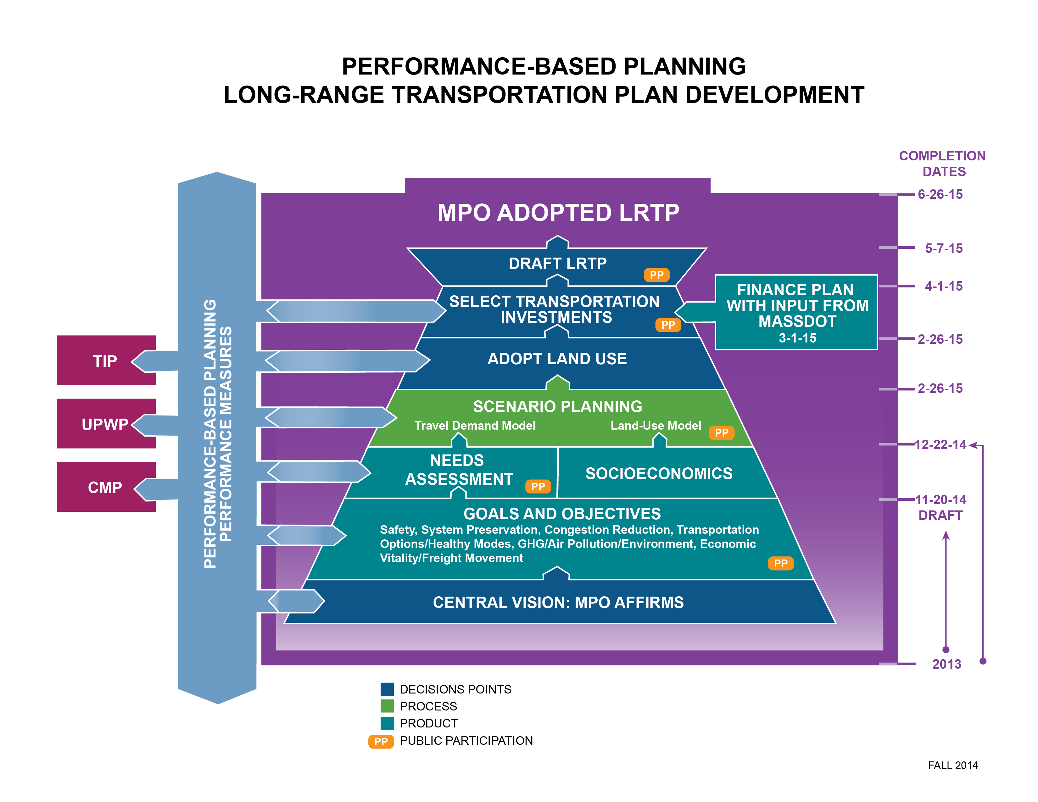
The Boston Region Metropolitan Planning Organization (MPO) is developing its next Long-Range Transportation Plan (LRTP), Charting Progress to 2040, which will provide a 25-year vision for transportation in the Boston metropolitan area. In this plan, the MPO sets priorities for future federally-funded transportation planning studies and capital-improvement projects.
The LRTP development process consists of several steps:
- Establish a vision, goals, and objectives for future transportation investments in the Boston region
- Identify the region’s transportation needs through assessing existing conditions and transportation system’s performance, and identifying issues to address in the future
- Scenario planning to consider investment strategies that will advance the region’s transportation goals
- Develop a plan that accounts for expected transportation funding over the next 25 years, analyze the greenhouse gas, air quality, and environmental justice impacts of the plan, and circulate the plan for public review and comment.
This document will serve as a guide for MPO member participation and decision making throughout the LRTP development process. It outlines each of these four steps, and also provides supplemental information from MPO planning tools and analyses.
1 • ESTABLISH VISION, GOALS, AND OBJECTIVES
First the MPO establishes a vision for transportation in the region. It sets goals and
objectives to:
- Guide the project and program selection process for the LRTP and Transportation Improvement Program (TIP)
- Guide MPO studies in the Unified Planning Work Program (UPWP)
- Monitor and evaluate the transportation system in the future
Draft Vision
The Boston Region Metropolitan Planning Organization envisions a transportation
system that is safe, provides equitable access, excellent mobility, and varied transportation options—in support of a sustainable, healthy, livable, and economically vibrant region.
Draft Goals and Objectives
The MPO’s draft goals and objectives are shown in the table below.
REVISED LRTP GOALS AND OBJECTIVES
DECEMBER 3, 2014
DRAFT VISION STATEMENT
The Boston Region Metropolitan Planning Organization envisions a modern transportation system that is safe, uses new technologies, provides equitable access, excellent mobility, and varied transportation options—in support of a sustainable, healthy, livable, and economically vibrant region.
REVISED DRAFT GOALS
SAFETY
Goal: Transportation by all modes will be safe.
Objectives:
- Reduce number and severity of crashes, all modes
- Reduce serious injuries and fatalities from transportation
- Protect transportation customers and employees from safety and security threats
SYSTEM PRESERVATION
Goal: Maintain the transportation system
Objectives:
- Improve condition of on- and off-system bridges
- Improve pavement conditions on MassDOT-monitored roadway system
- Maintain and modernize capital assets, including transit assets, throughout the system
- Prioritize projects that support planned response capability to existing or future extreme conditions (sea level rise, flooding, and other natural and man-made hazards)
- Protect freight network elements, such as port facilities, that are vulnerable to climate-change impacts
CAPACITY MANAGEMENT/MOBILITY
Goal: Use existing facility capacity more efficiently and increase healthy transportation capacity
Objectives:
- Improve reliability of transit
- Implement roadway management and operations strategies, constructing improvements to the bicycle and pedestrian network, and supporting community-based transportation
- Create connected network of bicycle and accessible sidewalk facilities (at both regional and neighborhood scale) by expanding existing facilities and closing gaps
- Increase automobile and bicycle parking capacity and usage at transit stations
- Increase percentage of population and employment within one- quarter mile of transit stations and stops
- Increase percentage of population and places of employment with access to bicycle facilities
- Improve access to and accessibility of transit and active modes
- Support community-based and private-initiative services and programs to meet last mile, reverse commute and other non- traditional transit/transportation needs, including those of the elderly and persons with disabilities
- Eliminate bottlenecks on the freight network
- Enhance intermodal connections
- Give priority in a congestion reduction program to major arterials and express highways throughout the region which serve transit and/or existing population and places of employment.
Note: The MPO is considering adopting this objective. The decision will be made after considering the results of scenario planning
CLEAN AIR/CLEAN COMMUNITIES
Goal: Create an environmentally-friendly transportation system
Objectives:
- Reduce greenhouse gases generated in the Boston region by all transportation modes as outlined in the Global Warming Solutions Act
- Reduce other transportation-related pollutants
- Minimize negative environmental impacts of the transportation system
- Support land use policies consistent with smart and healthy growth
TRANSPORTATION EQUITY
Goal: Provide comparable transportation access and service quality among communities, regardless of income level or minority population
Objectives:
- Target investments to areas that benefit a high percentage of low- income and minority populations
- Minimize any burdens associated with MPO-funded projects in low-income and minority areas
- Break down barriers to participation in MPO-decision making
ECONOMIC VITALITY
Goal: Ensure our transportation network provides a strong foundation for economic vitality
Objectives:
- Respond to the mobility needs of the 25–34-year-old workforce
- Minimize the burden of housing and transportation costs for residents in the region
- Prioritize transportation investments that serve targeted development sites
- Prioritize transportation investments consistent with the compact-growth strategies of MetroFuture
MPO Member Input:
Please fill out the survey to prioritize the goals and objectives. This information will be used by staff to develop investment strategies to be used in Step 3 – Scenario Planning Process. Please return your survey by email to amcgahan@ctps.org by Thursday November 13.
Please visit the Charting Progress to 2040 page on the MPO’s website (www.bostonmpo.org/Drupal/charting_2040) to learn more about the LRTP development process and provide your comments.
2 • IDENTIFY TRANSPORTATION NEEDS
Next, the Boston Region MPO will conduct a Needs Assessment to identify transportation needs within the MPO’s goal areas, which include but are not limited to, safety, congestion reduction, and transportation options. The Needs Assessment features a Web-based application that displays data on high crash locations, congested roadways, and walking, biking and transit coverage, along with data on other topics. The tool can be accessed at www.bostonmpo.org/drupal/charting_2040_needs. The MPO will use this information to guide development of investment strategies to address these needs.
The maps and data below reflect some of the needs that MPO staff has identified through the Needs Assessment process. For example, bottlenecks in the roadway system cause congestion and accidents and result in higher emissions of pollutants. MPO staff analyzed crash data and congestion information from the Needs Assessment to cite bottleneck locations with severe congestion and high crash severity in the Boston region.
Highway Bottlenecks
- Route 128 at Lowell Street (Exit 26) in Peabody
- I-93 between the Braintree Split and the Massachusetts Ave. Interchange
- I-90 between Interchanges 16 and 17 in Newton
- I-93 between I-95 in Woburn and the Leverett Connector
- I-95 between I-93 in Woburn and US 1 in Lynnfield
Arterial Bottlenecks
- Route 114 in Peabody and Salem
- Route 1A in Revere
- Route 16 from Cambridge to Revere
- Route 60 from Route 2 to Route 2A and Medford St. in Arlington
- Route 129 Wilmington to Reading
- Route 3A Marshfield to Quincy
- Route 16 from Holliston to Newton
- Route 28 Milton to Randolph
- Route 138 in Canton and Milton
- Route 9 Southborough to Newton
- Route 20 (Weston)
- Route 30 between I-90 and Route 9 (Framingham)
- Route 135 Wellesley to Natick
- Routes 62, 225 and 4 corridor in Bedford and Lexington
- Route 2 Bypass Road/Cambridge Turnpike to Piper Road/Taylor Road in Concord and Acton
Congestion on Highways by Planning Time Index
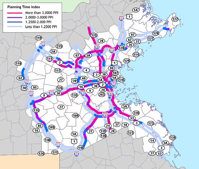
This map displays congestion on highways by planning time index. Planning time index measures the reliability of congestion based on the ratio of the 95th percent peak-period travel time to the free-flow travel time.
High Crash Locations by Equivalent Property Damage Only
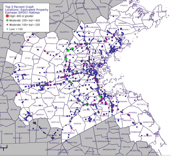
This map displays high crash locations by equivalent property damage only (EPDO). EPDO measures crash severity based on property damage, personal injuries, and fatalities.
High Priority Bike Gaps
- Massachusetts Central Trail in Waltham
- Upper Charles Trail in Framingham/Ashland/Sherborn
- Community Path/Greenline Extension in Somerville
- Sudbury Aqueduct Trail in Framingham
- Dorchester Connector in Boston
- Boston University bridge to Emerald Necklace in Boston
- Minuteman to Mystic Valley in Arlington
- Central Square in Cambridge
- Charlesgate in Boston
- Commuter Rail to East Boston Greenway in Chelsea
- Canal Street Bikeway in Salem
Transit Gaps
- Very densely populated areas in Lynn, Chelsea, Everett, and Medford, which generate significant numbers of trips into the urban core, do not have frequent rapid transit access within a reasonable walking distance.
- Very densely populated areas in Roxbury and Dorchester served by MBTA bus Routes 23 and 28 do not have frequent rapid transit access within a reasonable walking distance. Travel times on these routes are long and unreliable.
- Although the MBTA currently operates some circumferential bus connections between rapid transit spokes, buses must compete with cars on increasingly congested urban streets, reducing the appeal of these services. More frequent, circumferential, rapid, and through-routed connections would greatly enhance mobility between Central Area activity centers, as well as in the Route 128 corridor and other important destinations.
Regional High Priority Bike Gaps
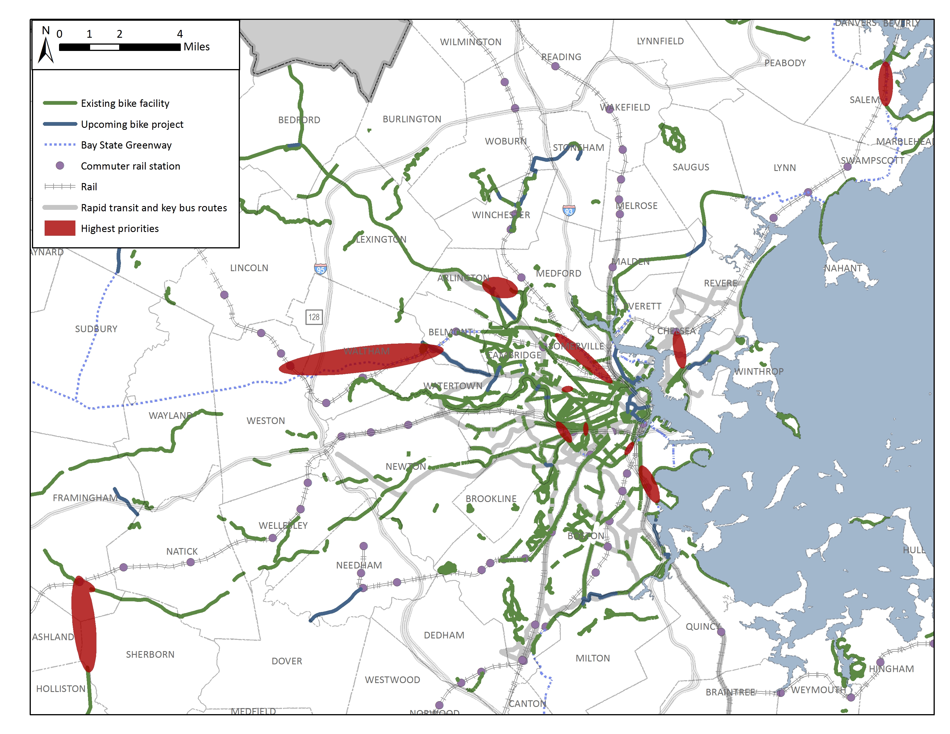
This map displays the high priority bike gaps in the regional bike network as prioritized by access to underserved communities, employment centers, town centers, central business districts, schools, universities/colleges, and parks or open space.
Population Density for Areas Beyond MBTA Transit Range
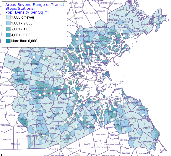
This map displays 2012 population density per square mile for areas beyond the range of existing MBTA transit stops.
Staff is completing the chapters that will provide information on land use, travel patterns, and the prioritized transportation needs in the MPO Region. Members can use this information as inputs into Step 3 – Scenario Planning and to ultimately decide on the recommended projects and programs that will be included in the recommended LRTP.
3 • SCENARIO PLANNING PROCESS
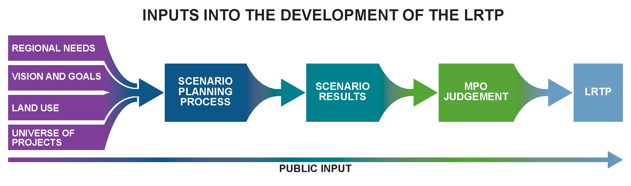
Scenario planning for developing this LRTP can help both the MPO and the public weigh the benefits and tradeoffs of a variety of investment strategies. The MPO will examine how allocating available dollars to various strategies would best address the identified transportation needs of the region, while advancing the MPO’s vision, goals, and objectives.
Using the inputs shown in the figure below, staff will craft two or three scenarios of alternative investment strategies for the MPO to review. Staff then will analyze the effects these scenarios would have on a selection of transportation-related indicators. Using the results of this scenario planning, the MPO will identify the recommended investment strategy for the final LRTP.
Scenario planning will continue to be utilized throughout the MPO’s performance-based planning and programming process, to update the region’s land use plan, and to plan individual transportation projects.
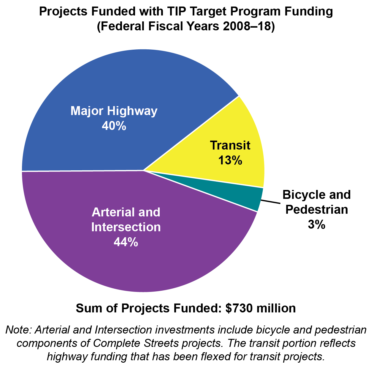
Summary of Recent Investments
Looking at past MPO investments is useful when considering how money should be spent in the future. Recent MPO investments have been guided by the MPO’s current goals of providing a transportation system that is well maintained, improves mobility for people and freight, and provides safe transportation for all modes. To advance these goals, the MPO has conducted studies and funded the construction of infrastructure projects. Below are examples of recent investments made in the Boston region.
Corridor investments that help to reduce crash severity, increase healthy transportation options, and reduce delay for all users.
Locations Studied:
- Routes 127/127A in Rockport and Gloucester (2014)
- Route 114 (I-95 to Peabody) in Danvers (2012)
- Route 203 (Gallivan Boulevard and Morton Street) in Boston (2012)
- Route 3A in Cohasset and Scituate (Henry Turner Bailey Road in Scituate to Commuter Rail Station in Cohasset) (2014)
- Route 30 in Framingham and Natick (2013)
- Route 126 from Bellingham to Framingham (2011)
- Route 2 (Concord Rotary through I-95, excluding Crosby’s Corner) in Concord and Lincoln (2013)
Projects:
- Reconstruction of Route 85 in Hudson (2011)
- Route 139 Corridor Improvements in Marshfield (2011)
- Reconstruction of Trapelo Road and Belmont Street in Watertown and Belmont (2012)
- Reconstruction of Route 129 (Broadway) in Lynn (2013)
- Reconstruction of West Street in Reading (2014)
- Reconstruction and Signal Improvements on Rantoul Street (Route 1A) in Beverly (2014)
Intersection investments that help to reduce crash severity and reduce delay for all users.
Locations Studied:
- Intersection of Humphrey St., Burrill St., and Monument Ave. in Swampscott (2012)
- Western Ave (Route 107) at Washington Street (Route 129) in Lynn (2013)
- Massachusetts Avenue at Appleton Street and Appleton Place in Arlington (2011)
- Main Street (Route 38/129) at Church Street/Burlington Avenue (Route 62) in Wilmington (2012)
- Franklin Street (Route 37) at West Street and Granite Street in Braintree (2013)
- North/South Franklin Street (Route 37) at Union Street/Plymouth Street (Route 139) in Holbrook (2013)
- Neponset Valley Parkway at Brush Hill Road and Milton Street in Milton (2011)
- Turnpike Road (Route 9) at Central Street/Oak Hill Road in Southborough (2012)
- Union Avenue at Mt. Wayte Avenue in Framingham (2011)
- Lincoln Street at Cox Street/Packard Street in Hudson (2011)
- Main Street (Route 117) at Still River Road (Route 110) in Bolton (2010)
- Central Street at Pearl Street in Stoughton (2010)
Projects:
- Route 2A and Waltham Street in Lexington (2010)
- Route 16 Intersection Improvements in Milford (2011)
- Intersection Improvements at Route 9 and Oak Street in Natick (2012)
- Intersection & Signal Improvements at Hancock Street and East/West Squantum Streets in Quincy (2014)
Bicycle investments that help to close gaps between existing facilities and expand access to transit stations, downtown centers, and schools.
Locations Studied:
- Danvers Rail Trail Crossing at Route 62/Poplar Street (2012)
- Glendale Square (Ferry Street and Elm Street) in Everett (2013)
- Oak Grove Station in Malden (2012)
- Braintree Station in Braintree (2012)
- Franklin Town Center (2010)
Projects:
- Upper Charles Trail, Phase 2 in Milford (2009)
- Somerville Community Path (2012)
- Bikeway Connection at Intersection of Route 3 and Route 60 in Arlington (2014)
- Tri-Community Bikeway in Winchester, Stoneham, and Woburn (2015)
Interchange investments that help to reduce crash severity and delay for motorists.
Locations Studied:
- I-95 southbound, at the off-ramp area of Interchange 32B in Burlington (2012)
- I-93/Southeast Expressway/Route 3 (Braintree Split) (2006)
- I-90 Interchange 17 (Newton Corner Rotary) (2007 and 2009)
- I-93/Route 24 Interchange; study area included parts of Randolph, Stoughton, and Canton (2007)
Projects:
- Interchange Improvements along Route 128 at Route 35 and Route 62 in Danvers (2010)
- Route 128 Improvement Program in Randolph (Contracts III, IV and V) in Randolph, Canton, Westwood, Dedham, Needham and Wellesley (2008-18)
- Route 2 (Crosby’s Corner) in Concord and Lincoln (2011-14)
Transit investments to increase transit usage and improve access and accessibility for all customers.
Locations Studied:
- SWAP Regional Public Transit Feasibility Study (2013)
- Evaluation of MetroWest Regional Transit Authority Fixed Route Network (2009; additional transit planning assistance in 2013)
- Assessment of Dudley South Corridor Bus Service and Potential Improvements (2009)
Projects:
- Assembly Square Station in Somerville (2011)
- Green Line Extension Project, Phase II in Somerville and Medford (2016-18)
Transit Projects
- Reduce more than 2200 tons of CO2 annually
- Improve transit access and transit service for areas of Somerville and Medford
- Support development of new housing units, retail and office space
- Launch GATRA transit service in Marshfield, Duxbury, and Franklin
- Support rail shuttle service in Acton
Arterial and Intersection Projects
- Reduce more than 3600 tons of CO2 annually
- Resurface approximately 95 lane miles of pavement
- Add 45 miles of bicycle lanes
- Improve 38 miles of sidewalks
- Add 32 miles of new sidewalks
- Serve more than 41 bus routes
- Improve access to 13 transit stations
- Improve safety at 5 high crash locations
- Address 2 bottleneck locations
- Add more than 10 miles of new roadway capacity
Bicycle and Pedestrian Projects
- Add more than 11 miles to the bicycle network
- Support launch of Hubway in Boston, Cambridge and Brookline
- Improve safety at one of the top 200 crash locations
- Facilitate hundreds/thousands of daily walking and bicycling trips
- Provide access to transit stations, schools, recreation and commercial areas
Major Highway Projects
- Improve safety at one of the top 200 crash locations and multiple interchanges
- Address a major bottleneck location
- Add travel lanes and shoulders along 3 miles of Route 128
Thinking about Future Investments
In the future, MPO investments will continue to be guided by MPO goals. In turn, these goals will guide prioritization of infrastructure projects funded through the TIP. Given that the MPO likely would not have enough funding to address all necessary investments, the MPO will weigh the tradeoffs of different strategies before allocating resources. One of the MPO’s investment strategies could involve establishing programs in the LRTP that advance multiple goals. Listed below are potential programs that could be included in the LRTP, along with examples of candidate projects drawn from the TIP Universe of Projects or other planning documents.
A bottlenecks program to address congested highway and arterial locations.
Goals Addressed: Congestion Reduction; Safety; Economic Vitality/Freight
Possible Projects:
- Mainline Improvements on Route 128 (Phase II) in Peabody
- Reconstruction of Bridge Street in Salem
- Construction of I-495/Route 1A Ramps in Wrentham
An intersection program to reduce crash severity and reduce delay for all users
Goals Addressed: Congestion Reduction; Safety; GHG/Air Pollution
Possible Projects:
- Intersection Improvements at Middle Street, Libbey Industrial Parkway and Tara Drive in Weymouth
- Traffic Signal Improvements at 11 Locations in Boston
- Intersection Improvements at Weymouth Street/Pine Street/Sycamore Street in Holbrook
- Route 20 at Concord Road in Marlborough
- Intersection & Signal Improvements at Route 30 and Wellesley in Weston
- Intersection Improvements at Route 1 and University Avenue in Norwood
A Complete Streets program to increase multi-modal transportation options and reduce delay.
Goals Addressed: Transportation Options/Healthy Modes; Safety; Congestion Reduction
Possible Projects:
- Reconstruction of Highland Avenue/Needham Street in Newton and Needham
- Reconstruction on Massachusetts Avenue in Lexington
- Reconstruction of Route 27 (Main Street) in Natick
- Signal and Intersection Improvements on Route 135 in Hopkinton
- Reconstruction of Ferry Street in Everett
- Improvements on Boylston Street in Boston
- Reconstruction on Route 1A (Main Street) in Walpole
A bike network program to increase healthy transportation options, enhance connectivity and improve safety.
Goals Addressed: Transportation Options/Healthy Modes, GHG/Air Pollution; Safety; Congestion Reduction goals
Possible Projects:
- Multi-use Path Construction on New Fenway in Boston
- Cochituate Rail Trail, Phase Two in Natick
- Minuteman Bikeway Extension in Bedford
- Emerald Necklace Crossing at Route 9 in Brookline
- Canal Street Bikeway in Salem
- Extension of the Upper Charles Trail in Holliston
- Assabet River Rail Trail in Stow
- Woburn Loop Bikeway
A pedestrian connections program to improve safety and increase healthy transportation options.
Goals Addressed: Transportation Options/Healthy Modes; Safety; GHG/Air Pollution
Possible Projects:
- Pedestrian Improvements along Elm Street and Rustcraft Road in Dedham
- Pedestrian Improvements along Bussey Street in Dedham
A transit program to preserve the system and increase healthy transportation options, which could consist of state of good repair needs not included in the MBTA’s Capital Investment Program or system expansion projects listed in the Program for Mass Transportation.
Goals Addressed: Transportation Options/Healthy Modes; Transportation Equity; Other goals depending on the project
A major infrastructure program for major modernization or expansion projects that impact regional ravel.
Goals Addressed: System Preservation; Congestion Reduction; Safety; Transportation Options; Economic Vitality/Freight
Possible Projects:
- Reconstruction of Rutherford Avenue in Boston
- Woburn – Interchange Improvements to I-93/I-95
- Boston – Reconstruction of Rutherford Avenue
- Malden, Revere and Saugus – Reconstruction and Widening on Route 1
- Framingham – Intersection Improvements at Route 126/135/MBTA and CSX Railroad
- Braintree – I-93/Route 3 Interchange (Braintree Split)
- Concord – Improvements and Upgrades to Concord Rotary
- Marlborough and Hudson – I-495/I-290/Route 85 Interchange
- Somerville – McCarthy Boulevard Construction
An interchange modernization program to modernize outdated interchanges in the system to improve safety and reduce congestion.
Goals Addressed: System Preservation; Congestion Reduction; Safety; Economic Vitality/Freight
Possible Projects:
- Natick – Route 27 over Route 9 Interchange Improvements
- Saugus – Interchange Reconstruction at Walnut Street and Route 1
- Wrentham – Construction of I-495/Route 1A Ramps
- Beverly – Interchange Reconstruction at Route 128/Exit 19 at Brimbal Avenue (Phase II)
- Newton – Improvements of Route 128/I-95 and Grove Street
- Southborough and Westborough – Improvements at I-495 and Route 9
Moving forward, the MPO will need to consider the following components that go into the scenario planning process:
1. Prioritize goals and objectives (decided in Step 1 – Visions, Goals and Objectives)
2. Identify what portion of each scenario will consist of major infrastructure projects
3. Decide what portion of the remaining unallocated funding could be allocated to programs
4 • FINALIZING THE PLAN
Once the three LRTP development steps—establishing a vision, goal and objectives; identifying needs; and scenario planning—are completed, the MPO will have many of the necessary inputs to develop a draft LRTP. Information about expected land use and transportation funding over the life of the plan also will support an MPO staff recommendation for a preferred transportation investment approach. After the MPO has decided upon a preferred investment approach, staff will conduct air-quality, greenhouse-gas, and environmental-justice analyses of the approach. Staff will also develop supporting chapters on various aspects of the planning process and the selected investment approach that will be included in a draft LRTP document. The MPO then will approve a draft LRTP document for public review and comment, and MPO staff will gather this feedback. The MPO will consider the public’s comments as it decides upon a final LRTP to endorse.
The LRTP, when approved by the MPO and federal transportation agencies, will shape all aspects of MPO planning. In particular, it will provide direction for the types of capital projects included in the TIP, and planning activities included in the UPWP. It also will lay the foundation for the MPO’s performance-based planning process, which the MPO will use to monitor progress toward achieving its goals and objectives.